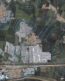
Ancient Egyptian city located in Nile Delta by radar
- Published

Radar imaging shows the outlines of the ancient city's streets and houses
An ancient Egyptian city believed to be Avaris, the capital of the Hyksos people who ruled 3,500 years ago, has been located by radar, Egypt's culture ministry says.
A team of Austrian archaeologists used radar imaging to find the underground outlines of the city in the Nile Delta, a now densely populated area.
The Hyksos were foreign occupiers from Asia who ruled Egypt for a century.
Avaris was their summer capital, near what is now the town of Tal al-Dabaa.
The radar images show the outlines of streets and houses underneath the green farm fields and modern towns in Egypt's Delta.
Egyptian antiquities chief Zahi Hawass said in a statement that the area could be part of Avaris, the summer capital of the Hyksos who ruled Egypt from 1664-1569 BC, during the 15th Dynasty.
"The pictures taken using radar [imaging] show an underground city complete with streets, houses and tombs which gives a general overview of the urban planning of the city," Dr Hawass said in a statement.
Irene Mueller, who heads the Austrian team, said the main purpose of the project had been to determine how far the underground city extended.
"The aim of the geophysical survey was to identify the size of the ancient city and the mission managed to identify a large number of houses and streets and a port inside the city," she said.
"The mission also identified one of the Nile river tributaries that passed through the city, as well as two islands," she was quoted as saying in the statement.