Estate map from 1729 on show after restoration
The 300-year-old map is the oldest surviving of the Blickling estate and parish
- Published
A 300-year-old map of a sprawling estate now in the care of the National Trust has gone on display after extensive conservation work.
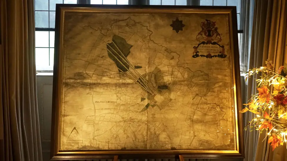
The hand-coloured parchment details Blickling, near Aylsham, Norfolk, as it was in 1729, which includes its walled garden, lake and "goose foot avenues".
In March, the map was sent to be cleaned, remounted and reframed, and have its splits and tears repaired.
The National Trust said it was the only surviving historical plan of Blickling and "highly significant in terms of the social history of the estate".

The map shows avenues leading off to the west and the lake labelled as a pond
Blickling estate's property curator, Megan Dennis, said: “John Hobart, 1st Earl, was passionate about Blickling and wanted to record his beloved estate.
"He employed James Corbridge, a young surveyor, to complete this fine, hand-coloured parchment map of his land.
"The map shows how John completely reorganised the gardens and parkland in the early 1700s.
"He turned the axis of the estate west-east, created the lake, and laid out the avenues, one of which we can still see today."
She added: “It’s interesting to look at well-known features in the Blickling landscape, such as the lake, which is labelled ‘New Pond’ on Corbridge’s map – back in 1729 it was only a third of the size it is today."
Avenues in the shape of a goosefoot, only one of which survives today, and a fourth avenue linking to the road at Itteringham may indicate Corbridge was drawing a new design instead of recording what was already there, she explained.

Splits in the parchment have since been repaired
Conservator Nicholas Burnett said the initial task of removing plywood to which the map had been adhered in the 20th Century proved "tricky and time-consuming", and took 100 hours.
"The starchy glue was strong, and the plywood had to be removed in stages, first with chisels, then a sander, and finally picked off with scalpel, and tweezers to reveal the back of the map," he said.
When the ribbon edging was removed, the original yellow border and a black and white scale, painted by Corbridge in the bottom left corner, could be seen for the first time in 50 years, the National Trust said.
The map will be on display within Blickling Hall until 10 November and will be given a new and permanent location early next year, it added.

Fine chisels were used for greater control when removing the first layer of plywood
Get in touch
Do you have a story suggestion for Norfolk?
Follow Norfolk news on BBC Sounds, Facebook, external, Instagram, external and X, external.