What we know as tsunami alerts issued after Russia earthquake

- Published
A massive 8.8 magnitude earthquake off Russia's far eastern coast sent tsunami waves into Japan, Hawaii and the US west coast on Wednesday morning.
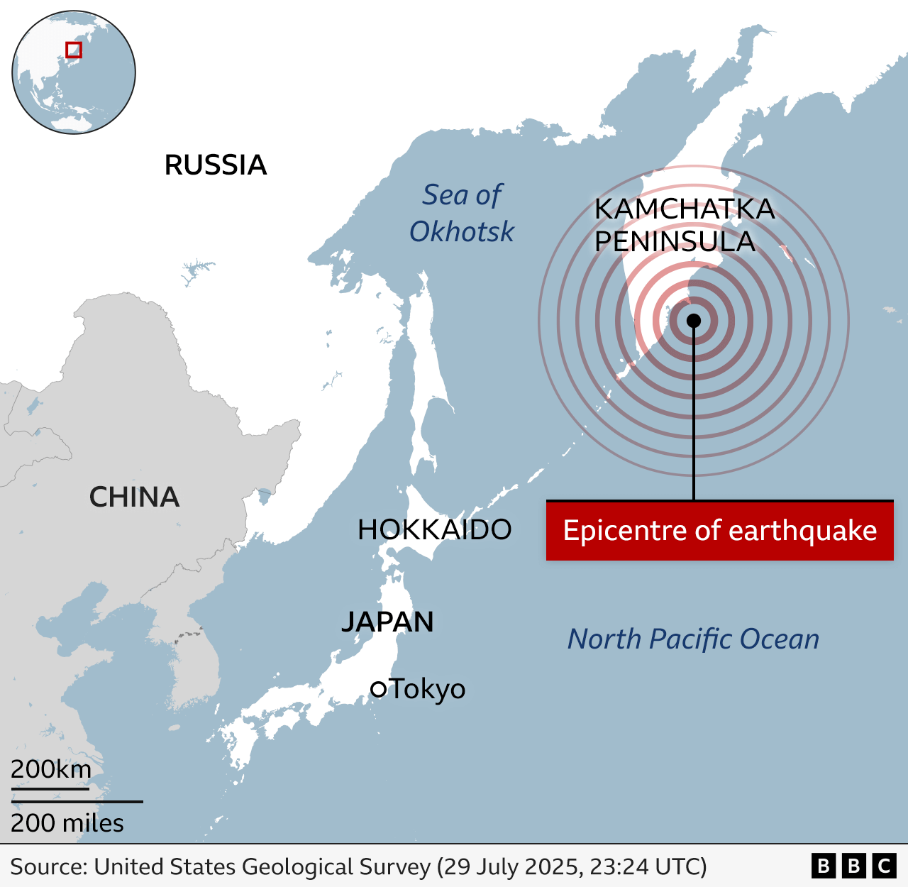
The earthquake, which hit near Russia's Kamchatka Peninsula at about 11:25 local time (00:25 BST), is believed to be one of the most powerful ever recorded.
Several people are said to have been injured - but there were no immediate reports of fatalities.
More than two million people across the Pacific were ordered to evacuate - but most tsunami warnings have since been downgraded.
Alerts were also issued in China, the Philippines, Indonesia, New Zealand and even as far as Peru, Chile and Mexico.

What damage have the earthquake and tsunami caused so far?
It appears the impact of the tsunami waves has not been as serious as first feared.
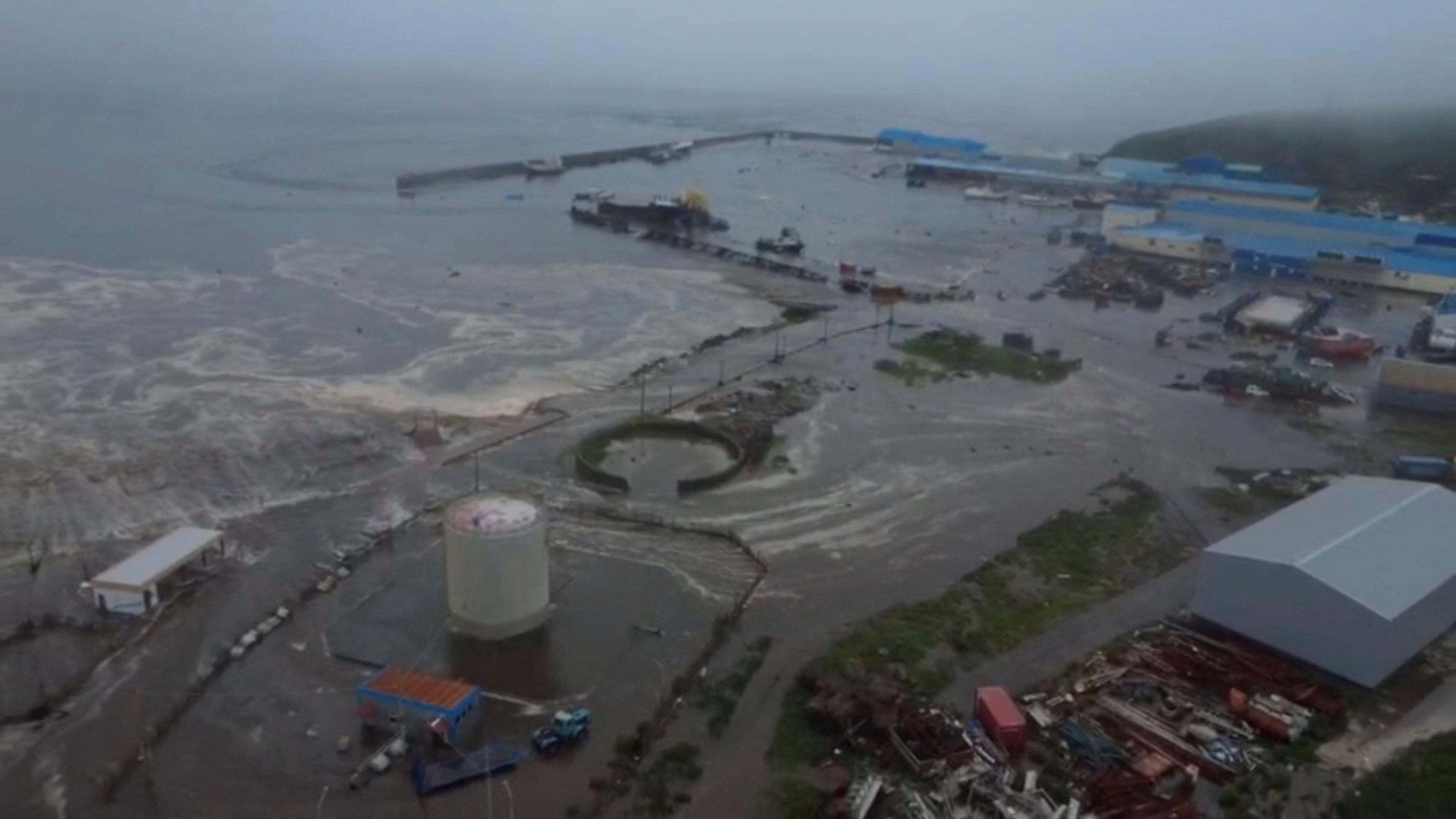
Videos have emerged showing large waves surging past buildings in the town of Severo-Kurilsk, Russia. Authorities said 4m (13ft) waves flooded the port and a fish processing facility, and vessels had been swept from their moorings. A power grid was also damaged in Russia's Sakhalin region.
Russia has lifted tsunami warnings for Sakhalin and Kamchatka, local officials said.
In Japan, about 1.9 million people were asked to evacuate and authorities urged residents to reach higher ground. Japan's weather agency has since downgraded all of its tsunami warnings to advisories.
In Hawaii, officials first warned of possible 10ft waves, but the tsunami warning covering the island has also now been downgraded to an advisory level, the Pacific Tsunami Warning Center said.
This means there is the potential of strong waves, minor flooding and strong currents, but that a major tsunami is not expected to hit. Those evacuated may return home, Stephen Logan, the Hawaii Emergency Management Agency's director, said on Wednesday morning.
Watch: Major earthquake off Russia triggers widespread tsunami warnings
How bad could the damage be?
The worst threat appears to have passed - though authorities are asking people to remain vigilant with tsunami advisories in many countries.
"Even now, scientists are running new models to try to refine initial forecasts," Chris Goldfinger, Professor of Marine Geology at Oregon State University told BBC Breakfast.
"Each country, each port, and each coastline will experience a very site-specific response."
He said the extent of the impact depends largely on the path of energy radiating from Russia's Kamchatka peninsula. Areas directly in line with that energy - roughly southeast from the epicentre - are expected to be most affected.
He said it takes about "eight to nine hours" for a tsunami from Kamchatka to reach the US west coast.
What's the timeframe?
The earthquake struck at about 11:25 local time (00:25 BST) on Wednesday.
Tsunami waves hit parts of North America's west coast at around 12.20 local time (09.20 BST).
"A good rule of thumb for tsunami waves is that they travel at about the speed of a jet plane," Helen Janiszewski, assistant professor in geophysics and tectonics division at the University of Hawaii, told the BBC.
"So if you think of how long it would take to travel by plane from one place to another, that is how long it takes for waves to travel from the quake epicentre to hit elsewhere," she said.
How does it compare to previous earthquakes?
The US Geological Survey said the earthquake was relatively shallow - striking at a depth of 20.7km (12 miles), and centred 119 km east-southeast of Petropavlovsk-Kamchatsky.
It was initially recorded as an 8.0 magnitude earthquake but later revised upwards. A series of strong aftershocks have also been recorded.
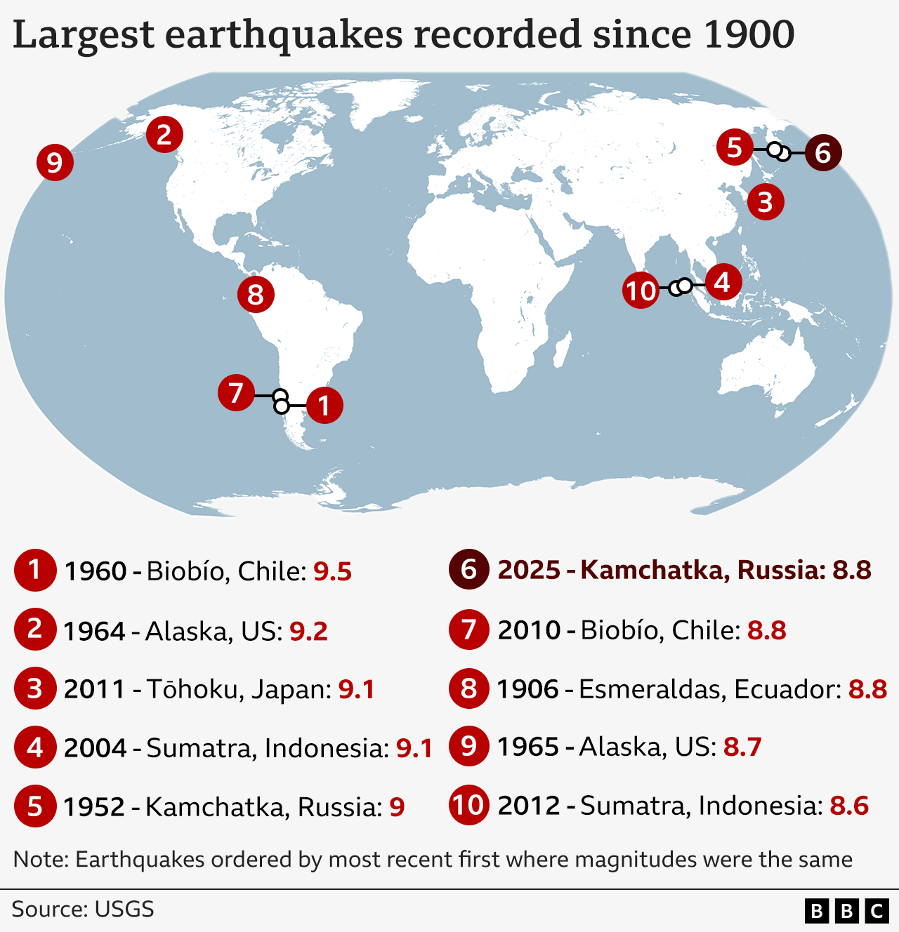
It is tied for the sixth most severe quake in history, with the 2010 earthquake in Biobío, Chile, and the 1906 earthquake in Esmeraldas, Ecuador.
The fifth most severe earthquake was also in Kamchatka Krai, Russia, in 1952. It was "the world's first recorded magnitude 9 earthquake".
By comparison, the 2004 Indian Ocean earthquake and tsunami - which killed over 227,000 people - was a 9.2-9.3 magnitude earthquake.
That hit approximately 160km off the western coast of Sumatra, Indonesia - a densely populated area. Russia's Kamchatka Peninsula has very low population density.

Get in touch
Have you been affected by the issues in this story? Are you evacuating? If it is safe to do so please share your experiences