Summary

  1. Satellite images capture Jamaica devastation and new video evidence of Sudan executionspublished at 17:16 GMT

    Thomas Copeland
    BBC Verify Live journalist

    We’ll be closing up this BBC Verify Live page soon, so here’s an at-a-glance summary of what the team has been reporting on today.

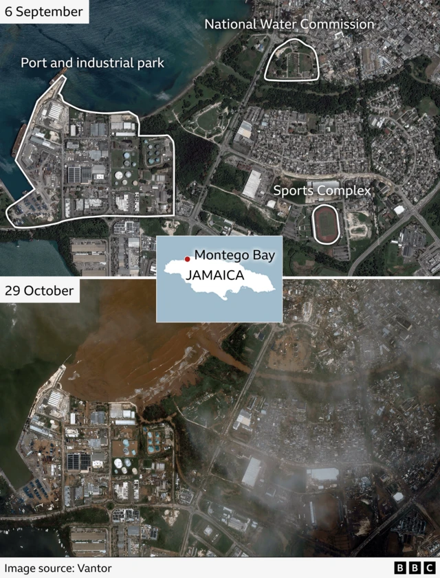
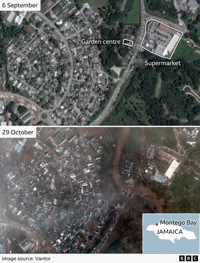
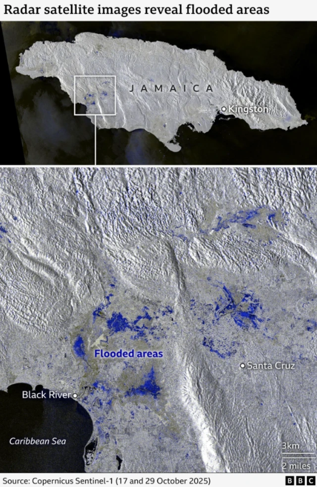
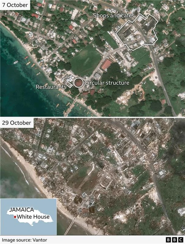
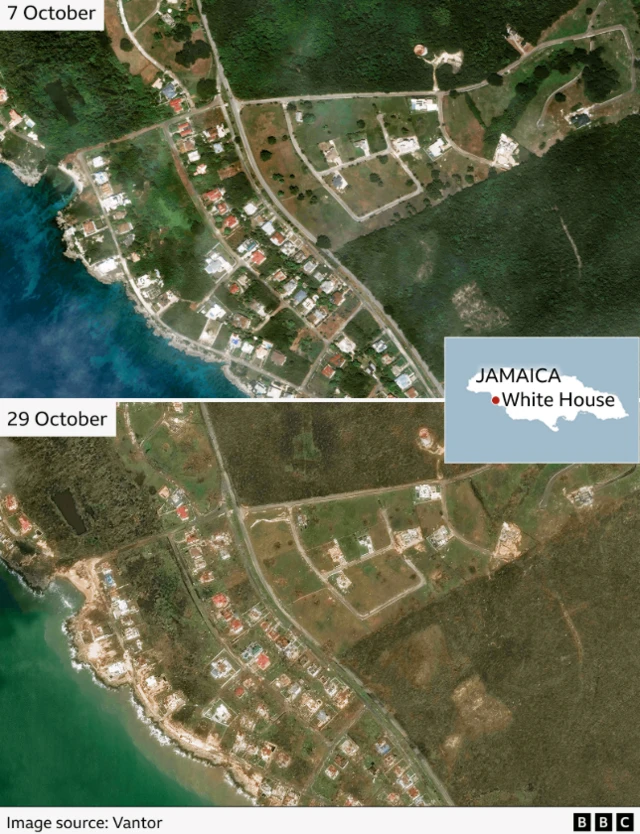
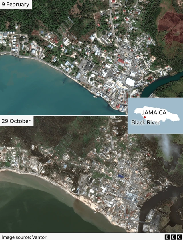
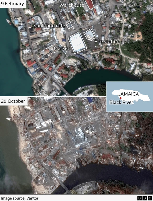
    We’ve been using satellite pictures to assess the path of devastation left by Hurricane Melissa after it ripped through across Jamaica this week, including:

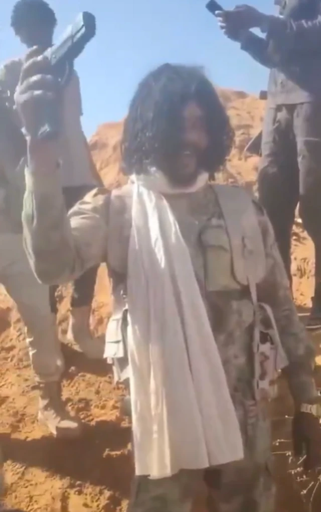
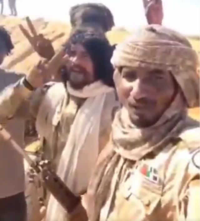
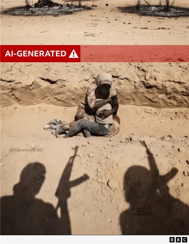
    The team has been working to verify graphic footage of killings carried out by Sudan’s paramilitary Rapid Support Forces after capturing the city of el-Fasher earlier this week. We’ve also debunked a fake AI image of a woman and child facing two gunmen - keep an eye on the BBC News social media accounts for a video with more on that later today.

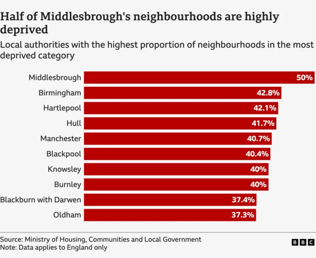
    In the UK, new figures have revealed the most deprived neighbourhood in England. Click here to read our data team’s analysis of the figures and use a tool they created to check how your area compares.

    Have you seen any images on your social media pages that you think might be AI-generated? Send them to us by clicking here.

    We’ll be back tomorrow for more live page coverage, thanks for joining us.

    BBC Verify banner
  2. Satellite imagery reveals extent of flooding in Jamaican tourist hotspotpublished at 16:40 GMT

    Thomas Copeland
    BBC Verify Live journalist

    We’ve been reviewing new satellite pictures from Jamaica today, showing how Hurricane Melissa left a path of devastation through two small towns on the south west coast.

    Now let’s cross to the north of the island to Montego Bay, the heart of the tourist industry and home to its main airport.

    In this city of more than 100,000 people, flooding is the most visible impact of the storm in the latest satellite pictures.

    Mayor Richard Vernon has told the BBC that “one side of the city is now cut off from the other due to roads being inundated by flood water”.

    In this before-and-after comparison you can clearly see how the once crystal blue water of the bay has been turned brown by sediment runoff.

    A before and after comparison of satellite pictures of Montego Bay

    The National Water Commission’s plant appears to be almost entirely submerged and muddy water is visible around the large blue tanks down at the industrial park by the port. It’s partly obscured by the clouds, but the Catherine Hall Sports Complex also looks like it’s flooded.

    Moving just a little bit east to the Barnett River, which has swelled far beyond its normal size, bursting its banks and flooding brown water downstream towards the bay.

    The red roof of a supermarket next to the river appears to have been ripped off, the car park is littered with debris and a small garden centre next to the river looks close to being washed away entirely.

    A before and after comparison of satellite pictures of Montego Bay
  3. How do we know which areas are the most deprived in England?published at 15:43 GMT

    Phil Leake
    BBC Verify data journalist

    Earlier we reported that Jaywick, near Clacton-on-Sea in Essex, is the most deprived neighbourhood in England.

    The report, known as the Index of Multiple Deprivation, organises England's into 33,755 neighbourhoods, home to 1,500 people on average, ranking them in order of deprivation.

    To calculate this order, the index combines 55 separate indicators across income, employment, education, health and disability, crime, barriers to housing and local services, and the living environment to create an overall measure of deprivation.

    Among the 296 local authority districts in England, Middlesbrough has the highest percentage of its neighbourhoods in the most deprived category, followed by Birmingham and Hartlepool.

    The index looks at living conditions across an area - not everyone in a highly deprived neighbourhood will be struggling, nor will all those in a less deprived area be well off.

    But it is a useful guide for central and local government and other bodies when deciding how to target resources for local services. For example, last year Jaywick’s local district council, Tendring, agreed a £126m 20-year improvement plan.

  4. Radar satellite images reveal extent of floods after Hurricane Melissapublished at 15:08 GMT

    Barbara Metzler and Erwan Rivault
    BBC Verify data journalists

    Today the team has been reviewing satellite images of Jamaica showing the scale of devastation left behind by Hurricane Melissa.

    To map the floods that followed the storm, we used Synthetic Aperture Radar (SAR) imagery. Because it uses microwaves rather than visible light, clouds, rain and darkness do not obscure the images it produces.

    This makes it particularly valuable for analysis when normal satellite images are too cloudy or taken at night.

    We were able to identify the areas in Jamaica most affected by flooding because water appears much darker than land in SAR images.

    The algorithm we created to do this separates flooded zones from both dry areas and places that usually hold water like lakes or rivers.

    Our analysis found around 11 square kilometres (four square miles) of flooded area, with most of the flooding in the west of the island near Black River and Santa Cruz.

    We also found some flooding in the western area of Savanna la Mar, around Wakefield in the north and smaller patches in central Jamaica to the north of James Hill and Lluidas Vale.

    SAR map of Jamaica showing flooded areas
  5. What we know about recent Russian advances in Pokrovskpublished at 14:51 GMT

    Paul Brown
    BBC Verify senior journalist

    The battle for control of Pokrovsk in the Donetsk region of eastern Ukraine has been a focal point of the war for the past 18 months.

    The town’s seizure would represent a significant gain for Russia, as it would secure a springboard for further advances towards the major population centres in Ukraine’s industrial heartlands like Slovyansk and Kramatorsk. Pokrovsk would also be a key hub for major supply routes via road and rail for Moscow’s troops in the Donetsk region.

    Russian Chief of General Staff Gen Valery Gerasimov has said the town is now surrounded, but Ukrainian President Volodymyr Zelensky has rejected this claim while also acknowledging his forces are under significant pressure there.

    Analysts have in recent weeks highlighted signs of Russian advances within Pokrovsk.

    The Institute for the Study of War (ISW) think tank reports sightings of Russian infantry in northern and western areas of the city, including around the railway station.

    We have verified footage posted yesterday apparently showing a single Russian soldier firing at a Ukrainian soldier around a mile (1.6km) west of the station.

    These observations largely align with those of the pro-Ukrainian open-source intelligence group Deep State, who yesterday called the situation in the city "difficult". They maintained, however, that Ukrainian forces continue to hold positions in the city.

    Map of the frontline in eastern Ukraine marking out Russian and Ukraine controlled areas, with Pokrovsk nearly encircled. Major cities like Kramatorsk and Slovyansk are still under Ukraine's control and marked.
  6. Jaywick named most deprived neighbourhood in Englandpublished at 14:21 GMT

    Christine Jeavans
    BBC Verify senior journalist

    The government has released some very detailed , externalnew figures on deprivation at a neighbourhood level in England today.

    Jaywick in Essex has been named the most deprived place in England for the fourth year in a row. The area to the west of Clacton-on-Sea also topped the list, known as the Index of Multiple Deprivation, in 2019, 2015 and 2010.

    Seven areas in Blackpool are also in the top 10, alongside one area of Hastings and one in Rotherham.

    The index ranks each of England’s 33,755 neighbourhoods which have an average population of 1,500. Officials combine data on income, employment, education, health, crime, barriers to housing and local services and the living environment to give each neighbourhood an overall score.

    They also group those small areas into local authorities. Half of the neighbourhoods in Middlesbrough are very deprived, the highest proportion among the 296 local authorities in England.

    Birmingham has the next highest proportion at 43%, followed by Hartlepool and Hull on 42% each.

    The spread of deprivation in England has risen in the last five years, with 65% of local authorities containing at least one highly deprived neighbourhood - up from 61% in 2019.

    Chart showing the 10 English local authorities with the highest proportion of very deprived neighbourhoods.  Middlesbrough is top with 50% of its neighbourhoods being highly deprived, followed by Birmingham on 42.8%, Hartlepool on 42.1%, Hull on 41.7%, Manchester on 40.7%, Blackpool on 40.4%, Knowsley and Burnley each on 40%, Blackburn with Darwen on 37.4% and Oldham on 37.3%

    You can check the pattern of deprivation in your area by using the lookup we’ve included in our full analysis of the data.

  7. JD Vance repeats baseless claim about Haitian migrants eating cats and dogspublished at 13:57 GMT

    Jake Horton
    BBC Verify journalist

    US Vice President JD Vance has repeated the baseless claim that Haitian migrants have been eating cats and dogs, first made by Donald Trump in the lead up to last year’s presidential election.

    In an interview published yesterday with the New York Post, Vance returned to the subject of Haitian people moving to the city of Springfield, Ohio.

    After the interviewer suggested they had been “eating cats and dogs”, Vance agreed and repeated the claim - but there’s no evidence for it.

    When we investigated the claim last year, Springfield city officials told BBC Verify there had been “no credible reports" of Haitian people eating cats and dogs.

    It’s unclear where the bogus claim originated from, but during a city meeting last August a local resident accused Haitian immigrants of slaughtering park ducks for food.

    Another claim about a cat being killed by Haitians was posted on a Facebook group focusing on crime in Springfield. It was attributed by the poster to the friend of a neighbour’s daughter.

    You can read our full report into the claim here.

  8. Shops, cafes and restaurants wiped out by Hurricane Melissapublished at 13:25 GMT

    Thomas Copeland
    BBC Verify Live journalist

    Earlier today we showed you satellite imagery from the Jamaican town of Black River, which has been devastated by Hurricane Melissa.

    I’ve been assessing the damage in other places in the south-western part of the island, where the storm first made landfall. Among those also badly hit is a fishing village of around 4,000 people called White House, a little over 20 minutes drive along the coast road.

    In this first side-by-side comparison we can see the roof of a large circular structure has been ripped to shreds, while the Marva’s and Pelican Lookout restaurants next to it appears to have completely gone.

    Up the main road is what remains of a collection of shops, cafes, a pharmacy and a deli. These businesses are all now barely distinguishable from the surrounding debris.

    Before and after satellite image showing most of White House has been destroyed

    Just a half hour walk back down the road towards Black River, there’s a small hamlet called Sandy Ground with neat rows of ocean-view homes, some of which are rented out as guesthouses.

    The damage here appears to be more mixed. The roofs of some of the houses appear to be intact, with the red tiling still clearly visible, while others have fared far worse and have gardens littered with building debris.

    Before and after satellite image showing much of Sandy Ground has been destroyed
  9. New footage shows RSF fighter shooting at site of mass killings in Sudan citypublished at 13:16 GMT

    Peter Mwai
    BBC Verify senior journalist

    New verified footage has emerged providing further evidence that a prominent fighter from the paramilitary Rapid Support Forces (RSF) has been involved in carrying out in executions in el-Fasher.

    The city in western Sudan was the last major army stronghold in the Darfur region and fell to the RSF on Sunday.

    Yesterday, we verified a clip of the fighter, known as Abu Lulu, executing an injured man in civilian clothing. The new video shows him repeatedly firing a pistol into motionless people in a ditch, then raising the gun into the air.

    We can confirm it was filmed was the same place to north-west of el-Fasher as earlier footage we’ve analysed, as we can see the same vehicles on fire and dozens of bodies scattered around the area.

    Abu Lulu’s clothing matches and we can identify another man who appears alongside him in both clips.

    Yesterday, RSF commander Gen Mohamed Hamdan Dagalo, known as Hemedti, acknowledged that his fighters may have committed violations in el-Fasher. He pledged to investigate and hold anyone found guilty accountable.

    We are also looking at reports by the World Health Organization (WHO) that more than 450 people were killed in a hospital in el-Fasher.

    The RSF has issued a statement dismissing the claim saying as “baseless”. We will update you if we find more on this.

    Abu Lulu holding a pistol in the airImage source, X
  10. Analysing video evidence of executions after RSF militia takes key Sudan citypublished at 12:28 GMT

    Peter Mwai, Merlyn Thomas and Matt Murphy
    BBC Verify

    Warning: This post contains graphic descriptions of executions.

    Abu Lulu wearing camouflage clothing and holding an assault rifle and putting up a v for victory sign with his index and middle finger, standing next to and another RSF memberImage source, Telegram

    Fighters from the paramilitary Rapid Support Forces (RSF) have executed a number of unarmed people after capturing the Sudanese city of el-Fasher, new videos analysed by BBC Verify show.

    Most of the clips are recorded in dusty rural locations, making it hard to say where exactly they took place. However, we did geolocate one video showing the summary shooting of an unarmed man at a university building in el-Fasher.

    The clip showed the man sitting amid dozens of dead bodies in a hallway. As the video progressed, he was seen turning towards the camera which followed an armed man who was descending the stairs. The fighter then raised his rifle and fired a single shot knocking the unarmed man to the ground, where he lay motionless.

    A number of similarly distressing clips are circulating online, but are difficult to geolocate as they are recorded outside the city itself where there are very few visible landmarks. But BBC Verify has managed to place one of the fighters - a man who goes by the name of Abu Lulu online and who appeared in multiple execution videos - in the area around el-Fasher in recent days.

    To find out more about how BBC Verify authenticated these clips read our full story here.

  11. AI image of woman and child facing Sudan gunmen goes viralpublished at 12:08 GMT

    We’ve been working over the last few days to authenticate footage of killings carried out by Sudan’s paramilitary Rapid Support Forces (RSF) after capturing the city of el-Fasher earlier this week.

    While much of the graphic material appearing online is real, one image that has gathered millions of views online was actually generated using artificial intelligence.

    The image appears to show the shadows of two men holding guns in front of a woman on the ground holding a young boy. In the background there are scorch marks on the ground, as if to indicate that houses or tents have been torched.

    How do we know it’s AI-generated?

    There are some immediate visual clues which tell us it was made with AI, like how we can see what appears to be shadows of the men, but there are no shadows behind the woman.

    The AI image being shared has a small watermark in the bottom left with a username. This led us to an Instagram account which first posted an animated version of this same scene.

    The caption on the post says the scene is AI-generated and the creator describes themselves as a “Creative AI Specialist” in their profile.

    In the animated scene, there are more obvious visual clues of AI generation, like how the woman’s and boy’s arms move through each other in impossible ways.

    We also ran the image through Google’s deepfake detection tool and it found Google AI generation digital watermarks in the image.

    A ai-generated image of a woman holding a young boy while sitting on the ground in a sandy ditch. In the forground are the silhouttes of two men holding assault rifles pointed in the air. In the background are burnt-out circles on the ground with debris.
  12. Drone strikes on key Ukrainian town entrance after Russian flag raisedpublished at 11:35 GMT

    Paul Brown
    BBC Verify senior journalist

    We've been watching for signs of Russian advances in the strategic town of Pokrovsk in eastern Ukraine. President Volodymyr Zelensky mentioned the city in his daily message to Ukrainians yesterday, saying it was the "toughest situation" on the front line "where Russian forces are most concentrated".

    The fight for control of Pokrovsk has been raging for two years as part of Russia’s efforts to seize control of Ukraine’s Donetsk region - and Zelensky even visited the town in November last year, where he took a selfie at the monument marking its western entrance.

    I’ve verified footage showing a Russian flag installed at the same spot recently, a move apparently prompted drone strikes from both sides. according to one video we've seen.

    Sign which says Pokrovsk in Ukrainian with cyrillic lettering. A russian flag has been placed near to the Ukrainian flag that forms part of the monument.Image source, Telegram

    In a compilation video, one clip shows a drone strike on the newly-installed Russian flag, followed by a second shot from the viewpoint of a drone hitting a Ukrainian flag that forms part of the Pokrovsk monument.

    We'll continue to review social media footage and satellite imagery of the town, which Russian forces have secured a foothold and look closer to capturing than ever before.

  13. Before and after: Jamaican town 'totally destroyed' by hurricanepublished at 11:19 GMT

    Thomas Copeland
    BBC Verify Live journalist

    This morning I’ve been reviewing the latest satellite imagery from Jamaica which reveals the scale of devastation left behind by Hurricane Melissa, which killed four people as it ripped across the island yesterday.

    The town of Black River on the island’s south-west coast "has literally been totally destroyed" by the category five storm, Jamaica's PM Andrew Holness told the BBC.

    In these side-by-side comparisons of satellite pictures from before and after Melissa struck we can see the impact right where the Black River flows into the Caribbean.

    In this first wider view it’s clear most of the buildings in the town have been heavily damaged and there’s debris lining every street.

    In the bottom right you can see that the Black River has burst its banks and along the waterline sediment runoff has left a brown strip of muddy water.

    Before and after satellite images of Black River, with the after picture showing huge damage to the town's buildings and the river having flooded.

    When we zoom in closer to the town centre we can identify specific buildings. The large white building in the middle is the Black River Market - its roof has been ripped clean off. The same has happened to the orange roof of a warehouse at the top right.

    The fire station to the right of the market in this picture appears to be still standing but badly damaged. Most other buildings here in the town centre are in far worse shape, like the soul food cafe just above the market - it looks like it’s gone entirely.

    Before and after satellite images of Black River, with the after picture showing huge damage to the town's buildings.
  14. Satellite images of hurricane damage and Russian flags raised in key Ukraine townpublished at 10:28 GMT

    Adam Durbin
    BBC Verify Live editor

    Welcome to BBC Verify Live.

    Satellite images of Jamaica show the scale of destruction inflicted by Hurricane Melissa. Large areas of cities and towns across the island have been devastated by high winds and floods, and at least five people are confirmed to have been killed. We’ll bring you before-and-after comparisons of specific places to show you the extent of the damage, as well as specialist satellite analysis highlighting areas particularly affected by flooding.

    We’re also looking into videos showing Russian flags and drone strikes around the strategic Ukrainian town of Pokrovsk, which recent reports indicate is close to falling to Moscow’s forces after two years of fighting. Ukraine has been defending the key settlement from intensifying Russian assault in recent months, with Ukrainian troops there outnumbered eight to one and losing ground.

    Plus, after the team verified footage from Sudan showing the paramilitary Rapid Support Forces executing civilians, we’ve found that an image has gone viral apparently showing a woman and child about to be killed which is actually AI-generated.

    A banner saying BBC Verify