Summary
A man has died after a tree hit a car in County Donegal, as Storm Éowyn continues to batter the UK and Ireland
The strongest gust recorded today in the UK so far is 100mph in Drumalbin, Scotland, where the effects of the storm are described as "once in a generation"
Two rare red warnings for wind - meaning there's a danger to life - have now been lifted in Northern Ireland and parts of Scotland
You can check your forecast on BBC Weather and the latest travel updates in our post
More than one million customers are without power across the UK and Ireland
Travel disruptions are expected to continue in some parts of the country well into the weekend
Storm Éowyn live: We're bringing you live feeds from across the UK so you can follow the storm in real time, just press the watch & listen tab above
Have you been affected? Get in touch here
What to expect as Storm Éowyn hits UK
Live Reporting
Edited by Aoife Walsh
Watch: BBC correspondent braves Storm Éowyn's winds in Glasgowpublished at 17:04 GMT 24 January
NI ambulance service working at 'critical' levelpublished at 16:44 GMT 24 January
16:44 GMT 24 JanuaryThe severe weather has caused significant disruption to Northern Ireland's emergency responses.
Mark Cochrane, Northern Ireland Ambulance Service's strategic commander for Storm Éowyn, says the service has been operating at "critical incident level" throughout Friday.
He tells Radio Ulster's Evening Extra programme that the storm has brought "a whole new set of different challenges" for responders, including debris and blocked roads.
Staff have also experienced issues with getting to work, which has slowed down responses.
Scotland's FM warns storm 'not yet over'published at 16:13 GMT 24 January
16:13 GMT 24 JanuaryStorm Éowyn has made landfall in Scotland, with reported winds of about 100mph (160kph) causing "significant" issues.
Speaking after an emergency government meeting, Scotland's First Minister John Swinney warns that the storm is "not yet over" and a high level of vigilance is still needed.
He urges people to not to travel and that it will take time for recovery teams to spring into action due to treacherous conditions.
"Even once the red weather warning expires, severe weather warnings for wind, snow and ice remain in place across much of the country tonight and into tomorrow morning," he adds.
Neighbours 'lucky they weren't killed' after tree falls on housepublished at 16:00 GMT 24 January
16:00 GMT 24 January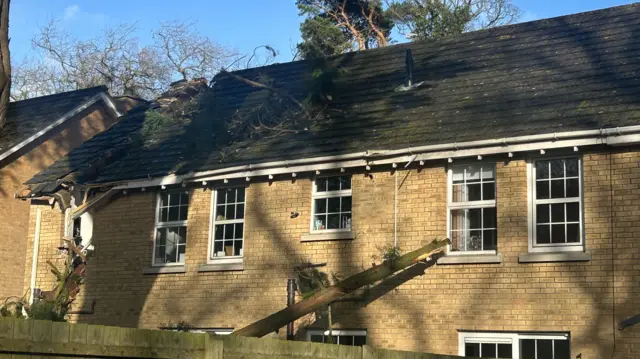
In Whiteabbey, County Antrim, Mary Greer is counting the costs after her house was damaged by a fallen branch after the high winds of Storm Éowyn.
It's the fourth time her home has been victim of bad weather in three years.
"I just heard a big bang and my heart sank," she tells BBC News NI.
"We have had a tree through our conservatory, we've had our car damaged and our roof damaged twice".
The house next door to Greer's has also been extensively damaged.
"The couple who were in there were so lucky they weren't killed," she adds.

Image caption, Mary Greer, pictured with her son John, has had yet more damage to her home
Watch: Troon street floods as Storm Éowyn batters Scotlandpublished at 15:44 GMT 24 January
15:44 GMT 24 JanuaryWhich areas are affected by Storm Éowyn?published at 15:22 GMT 24 January
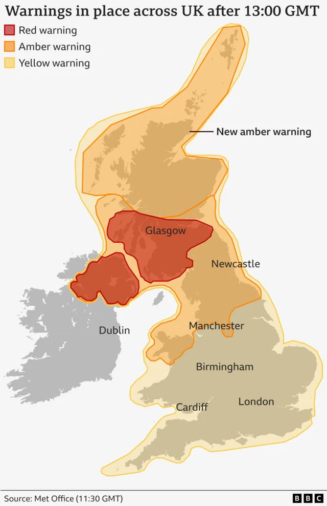
15:22 GMT 24 JanuaryThe Met Office has issued several weather warnings over Storm Éowyn for most of today - here's a look at which areas are affected:
- A red wind warning is in place until 17:00 in Central, Tayside and Fife, south-west Scotland and the Lothian Borders and Strathclyde
- An amber wind warning is in force across large parts of Scotland until 06:00 on Saturday
- A separate amber wind warning covers parts of Scotland, Northern Ireland and parts of northern England and it is in place until 21:00
- A yellow snow warning is in place until midnight and covers large parts of Scotland, including central Scotland and the Highlands
- A yellow warning for snow and ice is in place across all six counties in Northern Ireland
- Lastly, a yellow wind warning is in place for the Midlands, northern England, Scotland, Northern Ireland and Wales until midnight
Separate amber and yellow warnings for wind, ice and snow will come into force this weekend.
'Storm Éowyn hit like an earthquake'published at 15:05 GMT 24 January
15:05 GMT 24 JanuaryJames Kelly
UGC Hub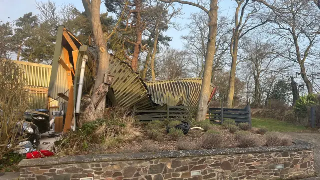 Image source, Mark Jones
Earlier this afternoon, I spoke with Mark Jones, who lives in Coldingham, Berwickshire in the Scottish Borders.
He describes Storm Éowyn hitting the area like “an earthquake”.
At 09:15 GMT, he saw his corrugated iron carport being lifted out of the ground and tipped into an area of woodland.
"I didn’t feel seriously alarmed because there was about 30ft between me and the carport and it just lifted up quite steadily and tilted over," he describes.
"I wouldn’t be able to guess at the weight of it but it must be many, many tonnes of metal and it’s just crumpled.
"I just think the word ‘storm’ is too mild for what we have witnessed here. Only a hurricane could do that."
How to stay safe during dangerous windspublished at 14:46 GMT 24 January
14:46 GMT 24 JanuaryLiving in the rain-soaked UK, we’re often used to hearing advice about staying safe during flooding - but what about when high winds pose a danger? The Met Office has some tips:
- Check for loose items outside your home to protect property and people from the risk of being hit by loose debris. This might include tying down garden furniture, or making sure bins and plant pots are tucked away in safe places
- If you do travel, plan your route and take essentials with you, including a charged mobile and food and drink
- Drive slowly and cautiously - particularly around high sided vehicles - and give cyclists, lorries and buses more room than usual
- If you live or work on the coast, beware of large waves and take care walking near cliffs
- Stay indoors as much as possible, and if you do have to head out, try not to walk or stop near buildings or trees
More than 1,000 flights cancelledpublished at 14:33 GMT 24 January
14:33 GMT 24 JanuaryMore than 1,000 flights - or 20% of all flights - operating to or from airports in the UK and Ireland have been cancelled today, data from aviation analytics company Cirium suggests.
Airports in Dublin, Edinburgh, Heathrow and Glasgow were the worst affected by Storm Éowyn, it found.
Earlier, we reported that Edinburgh had cancelled all flights until 17:00 GMT, warning that further disruption could come.
Strongest wind gust yet of 100mph recorded in Scotlandpublished at 14:20 GMT 24 January
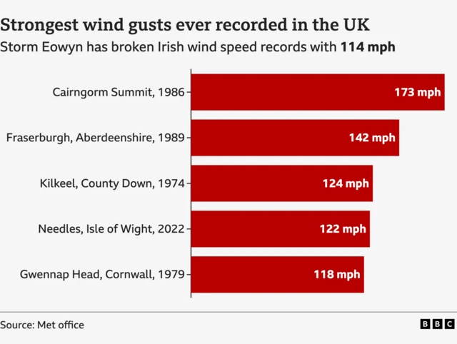
14:20 GMT 24 JanuaryA gust of 100mph has been recorded in Drumalbin in Scotland, the strongest in the UK today.
Roads firm Bear Scotland say a gust of 99.1mph was recorded on the Queensferry Crossing, the main bridge connecting Edinburgh to the north of Scotland.
It was followed by a gust of 96mph in Brizlee Wood, Northumberland, the Met Office says, and 93mph in Gwynedd, north Wales.
The strongest gust ever recorded in the UK was 173mph, in Cairngorm Summit, Scotland, on 20 March 1986.
Earlier on, we reported that the Republic of Ireland had reported its highest ever wind gust when a reading of 114mph (183km/h) was taken on the west coast.
The graphic below sets out how these gusts stack up against the strongest ever recorded in the UK.
Tree falls through roof of house in Northern Irelandpublished at 14:11 GMT 24 January
14:11 GMT 24 JanuaryA house in Newtownabbey, Northern Ireland, has been badly damaged after strong winds caused a tree to crash through its roof and land on a car below.
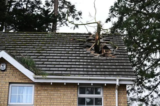 Image source, Getty Images
 Image source, Getty Images
Red warning ends in Northern Irelandpublished at 14:06 GMT 24 January
14:06 GMT 24 JanuaryThe red weather warning for wind from the Met Office has now ended in Northern Ireland.
It has been replaced by an amber warning which is due to remain in place until 21:00 GMT.
A yellow warning will be in force until midnight.
It comes as almost one million people are now without power across the island of Ireland as a result of Storm Éowyn.
About 725,000 are experiencing power outages in the Republic of Ireland, according to ESB, while NIE Networks says 240,000 customers are without power in Northern Ireland.
Some train services resume in Walespublished at 13:59 GMT 24 January
13:59 GMT 24 JanuaryEarlier, we reported that no trains were running to the west of Swansea, Wales.
Services have now resumed between Swansea and Carmarthen, according to Network Rail Wales.
However, trains remain suspended to the west of Carmarthen due to a fallen tree, but work is under way to reopen the railway.
In pictures: Storm damage across UKpublished at 13:52 GMT 24 January
13:52 GMT 24 JanuaryStorm Éowyn is slowly making its way across the UK, where its heavy winds have been hitting homes and commercial properties.
In Northumberland, one bungalow had its roof torn off, while Bangor leisure centre in Northern Ireland - which is under a red wind warning - also suffered damage.
 Image source, PA Media
Image caption, The roof of Bangor leisure centre fell victim to heavy winds that hit Northern Ireland
 Image source, PA Media
Image caption, Homes in Northumberland also suffered damage when heavy winds hit earlier today
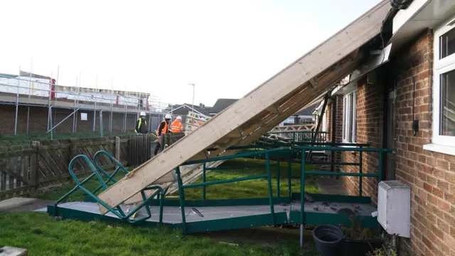 Image source, PA Media
Image caption, The roof even fell onto an accessibility ramp after crashing from its place
Scottish government to hold emergency planning meetingpublished at 13:45 GMT 24 January
13:45 GMT 24 January Andrew Kerr
BBC Scotland political correspondentScotland's deputy first minister has warned it will "take some time to clean up" and to get the transport networks back to normal as the country is battered by Storm Éowyn.
Kate Forbes also urged people once again to heed the advice from Police Scotland and not to travel in or to the red zone areas which will be worst affected.
She was speaking to the BBC ahead of attending the lunchtime meeting of the Scottish Government's Resilience Room (SGoRR) in Edinburgh - where the emergency services, transport providers and other critical agencies will update ministers on what's happening across the nation.
Forbes said the government had been preparing for this so they know what to expect - but they are also ready to respond to anything.
No trains running in Northern Irelandpublished at 13:27 GMT 24 January
13:27 GMT 24 JanuaryNorthern Ireland's public transport company Translink say they will not be running any trains today, adding that services tomorrow may also be impacted.
It adds that it is anticipated that bus services will also be affected this afternoon and evening.
The company's director of service operations, Ian Campbell, says that "significant work needed to assess the damage, undertake repairs and remove debris from the railway".
He adds that there are several railway lines blocked by fallen trees and debris.
 Image source, Getty Images
Fallen trees, fences and road accidents - the impact of Storm Éowyn so farpublished at 13:14 GMT 24 January
13:14 GMT 24 JanuaryThroughout the morning, we've been reporting on the disruption caused by ongoing weather conditions across the UK and Ireland.
We've rounded up some photos showing some of the damage Éowyn has caused.
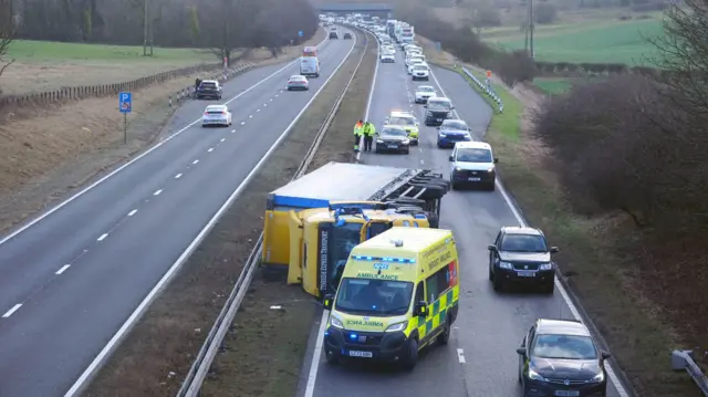 Image source, PA Media
Image caption, Emergency services attend the scene of a crash on the north bound A19 in Durham
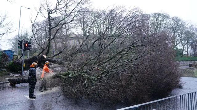 Image source, PA Media
Image caption, A fallen tree blocks a road on Regent Road, Edinburgh
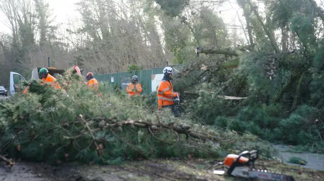 Image source, PA Media
Image caption, Liverpool has also dealt with fallen trees - like this one in Riverside Drive
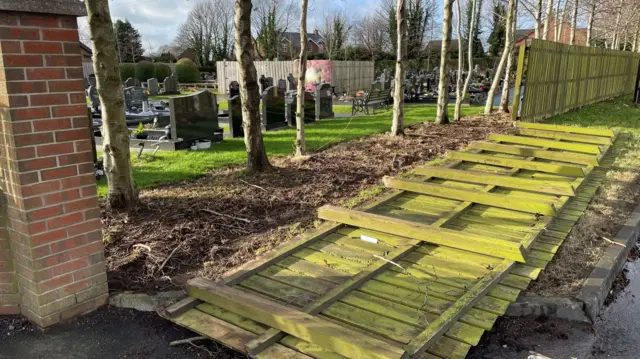 Image source, PA Media
Image caption, The wind has also taken down this fence in Blaris Road, Co Antrim
Big gusts of wind roaring in Glasgow Green as trees fallpublished at 13:07 GMT 24 January
13:07 GMT 24 January Catriona Renton
BBC Scotland reporter
In Glasgow Green the weather is worsening.
We are down by the River Clyde, and I have rarely seen it look so angry.
Usually weather stories are very visual - but what is striking is the noise. When the big gusts come, it is like a roar.
A couple of trees that line the boulevard have fallen by the river.
A lonely jogger was managing to plough through.
Stay safe and indoors.
New warnings in place this afternoonpublished at 13:01 GMT 24 January
13:01 GMT 24 JanuaryBreakingAs of 13:00 GMT, a new weather warning is in place, this time covering the Scottish Highlands.
The new amber warning for wind will be in place until 06:00 on Saturday.
Satellite imagery shows how Éowyn turned into a 'weather bomb'published at 12:55 GMT 24 January
12:55 GMT 24 January Ben Rich
Lead Weather PresenterMedia caption, Watch: Storm Éowyn moves across the Atlantic Ocean towards the Republic of Ireland and the UK
On it’s journey across the Atlantic, Storm Éowyn underwent a process known as “explosive cyclogenesis” – sometimes called a “weather bomb”.
This term is used to describe an area of low pressure that deepens by at least 24 millibars in 24 hours. Storm Éowyn deepened by 50 millibars in 24 hours – more than double the criteria.
Satellite imagery shows how the storm emerged from a band of cloud and rapidly spun itself up into a dangerous area of low pressure.
Explosive cyclogenesis is generally a sign of a storm that will bring extremely strong winds with damage and disruption - exactly as we’re seeing here.