Summary

  • Two people in the UK have died after their cars hit trees brought down by Storm Isha: a man in County Londonderry and another in Grangemouth

  • The strong winds and heavy rain have also caused travel disruption and left homes without electricity

  • Thousands of people are still without power on Monday in Northern Ireland, Scotland and northern England, with conditions making it unsafe for some crews to work on power lines

  • Parts of the UK have seen their strongest winds in 10 to 20 years; gusts of up to 99mph (159km/h) were recorded in Northumberland

  • A new storm - Storm Jocelyn - is expected to hit parts of the UK and Ireland from tomorrow, with more warnings for rain and strong winds

  • Train services in Scotland have been suspended from Tuesday evening and during commuter hours on Wednesday morning in advance of Jocelyn's arrival

  • You can follow the latest updates where you are by tuning into BBC local radio and regional TV

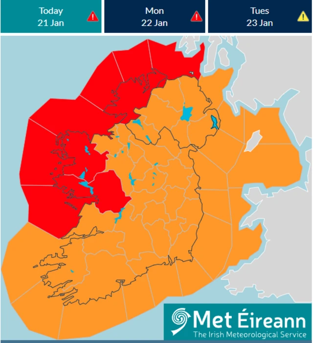
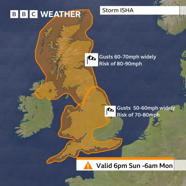
  1. In pictures: (Relative) calm before the stormpublished at 12:27 Greenwich Mean Time 21 January

    As we've been reporting, the worst of the wind gusts are anticipated to hit tonight when two amber warnings come into effect.

    "Widespread gales" are expected across the UK by the end of the day, and this morning some BBC Weather Watchers got out and about before the storm hit.

    Waves in Hastings East SussexImage source, BBC Weather Watchers/Peter and Leah
    Image caption,

    Winds were picking up in Hastings, East Sussex, earlier

    A snowman in Scotland
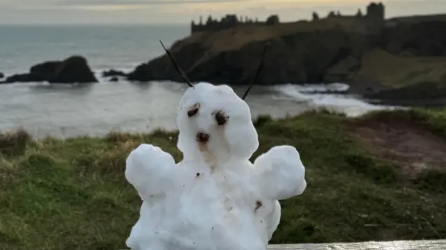
Image source, BBC Weather Watchers/Yorkshire Lass
    Image caption,

    In Stonehaven, Aberdeenshire, the remnants of the recent cold spell could still be seen

    A dog in Stoney Cross Hampshire
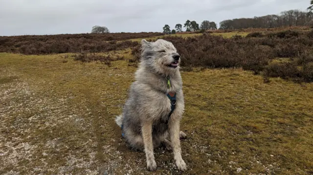
Image source, BBC Weather Watchers/ForestWanderer
    Image caption,

    This dog in Stoney Cross, Hampshire, took the brisk conditions in its stride

    Beach chairs in the windImage source, BBC Weather Watchers/Walking Tractor
    Image caption,

    While in Sheringham, Norfolk, these chairs looked ready to take flight

  2. Damage expected in NI as red warning issued in Republic of Irelandpublished at 12:18 Greenwich Mean Time 21 January

    Barra Best
    BBC News NI weather presenter

    High winds are forecast in Northern Ireland, gusting to up to 80mph (129km/h) on some coasts, with damageand disruption expected and travellers warned to exercise caution.

    As the storm increases in severity, an amber warning, the second highest level, comes into force from 18:00 GMT.

    The Department for Infrastructure (DfI) has advised people who need to travel to "exercise extreme caution".

    In the Republic of Ireland, a rare red status warning - the highest level - has been issued by Irish weather service Met Éireann for three counties.

    The red wind alert will come into force at 17:00 for counties Galway and Mayo, and 21:00 for Donegal.

    Weather alert for IrelandImage source, Met Eireann
  3. Several train services disrupted as passengers advised not to travelpublished at 11:58 Greenwich Mean Time 21 January

    Avanti service in Edinburgh WaverleyImage source, Getty Images

    Thousands of travellers are facing disrupted and cancelled journeys today as Storm Isha arrives in the UK.

    Avanti is advising against all travel today while other rail firms have cancelled services in Scotland and some early morning commuter services in and out of London tomorrow.

    The main disruptions to rail services include:

    • Avanti strongly advises customers not to travel on Sunday
    • LNER advises passengers not to travel north of Edinburgh between 16:00 on Sunday and 12:00 on Monday
    • TransPennine is advising against travel after 14:00 on Sunday between Preston and Edinburgh, and after 16:00 between Preston and Glasgow.
    • Southeastern is cancelling early Monday trains before 06:00 into and out of London so they can check lines for debris
    • ScotRail is ending outside the central belt after 19:00 on Sunday

    Other lines are advising travellers to avoid travelling during the storm where possible and to expect reduced speeds and delays to services.

  4. Where is Storm Isha now?published at 11:51 Greenwich Mean Time 21 January

    Matt Taylor
    BBC Weather

    After bringing heavy snowfall to north-east USA at the end of last week, the low pressure system that will bring heavy rain and strong winds to our shores is still out in the Atlantic at the moment, but developing as it approaches.

    Here's a look at where the system was located as of 09:00 this morning.

    Map showing storm weather system over the atlantic
  5. What's the latest weather forecast?published at 11:42 Greenwich Mean Time 21 January

    BBC Weather's Matt Taylor has the latest forecast for this afternoon and evening:

    Quote Message

    The daytime may be dry for parts of central and south-eastern England, as well as parts of northern Scotland, but rain will extend across many other areas.

    Quote Message

    The winds will strengthen too, with widespread gales by the end of the day. The strongest of the winds will be overnight and affect most parts of the UK. Unusually, there have been Met Office amber warnings for wind issued across almost all parts of the UK.

    Quote Message

    Gusts of 50 to 60mph will be felt widely across the UK, with 70 to 80mph around some coasts. Across Scotland, Northern Ireland and the far north of England there is a smaller risk of 90mph winds.

    Quote Message

    Impacts could include some structural damage, power and communication problems, and travel disruption. These could last well into Monday, including the morning rush hour."

  6. Gusts of 77mph recorded overnightpublished at 11:31 Greenwich Mean Time 21 January

    Matt Taylor
    BBC Weather

    Even though we will see winds re-strengthening through today and tonight, last night was a windy night for some too.

    Here's where some of the strongest gusts were recorded:

    • Stornoway: 77mph
    • Capel Curig: 72mph
    • Loftus: 61mph
    • St Marys, Scilly: 59mph
    • Mona: 58mph
    • Aberdaron: 56mph
    • Emley Moor: 56mph
  7. Watch: Widespread warnings as UK braces for Storm Ishapublished at 11:23 Greenwich Mean Time 21 January

    "Storm Isha is a fairly typical winter storm," says BBC Weather's Matt Taylor, but he warns "the impacts may be felt slightly more widely" than other recent storms.

    Damaging winds and heavy rains are due to affect most areas of the UK, potentially causing disruption to travel and power cuts.

    Watch the latest forecast from Matt Taylor below:

  8. Where have weather warnings been issued?published at 11:16 Greenwich Mean Time 21 January

    In short, most parts of the UK are under some sort of weather warning at this point.

    There are two amber wind warnings in place, which will take effect from 18:00 GMT this evening until tomorrow morning.

    One stretches across central, eastern and western England and all of Wales, only missing London and parts of the south-east. The other covers all of Scotland and northern England and Northern Ireland.

    The Met Office has warned the strongest winds are forecast to arrive tonight.

    Map showing amber warnings

    Separate yellow weather warnings for rain have also been issued.

    Warnings for rain in parts of northern England, external and parts of Wales, external began at midnight on Saturday and last until 06:00 on Monday, and a warning for rain in parts of Scotland, external runs from 15:00 GMT on Sunday to midnight.

    In addition, there is a warning for wind across all four UK nations, external from 12:00 on Sunday until 12:00 on Monday.

    • Read more about the storm here
  9. UK to be hit by winds of up to 80mphpublished at 11:12 Greenwich Mean Time 21 January

    Marita Moloney
    Live reporter

    Good morning. You join us as Storm Isha - the ninth named storm of this season - hits the UK.

    The Met Office has warned there could be gusts of up to 80mph (129km/h) in areas covered by its amber wind warnings, which cover much of England, Wales, Northern Ireland and Scotland from early evening on Sunday into Monday morning.

    This means there is potential for disruption to transport services and power outages.

    There are also yellow warnings for rain in place across the four nations, with forecasters saying there’s a risk to life in coastal areas due to large waves and debris being blown inland. Flooding is also likely.

    The Met Office says it is "relatively rare" for the whole of the country to be affected by storm warnings.

    It’s me here in our London newsroom, along with my colleagues Ece Goksedef and Anna Boyd. Stay with us for the latest updates, weather forecasts and pictures from around the UK.