German radar satellites fly tight space waltz
- Published

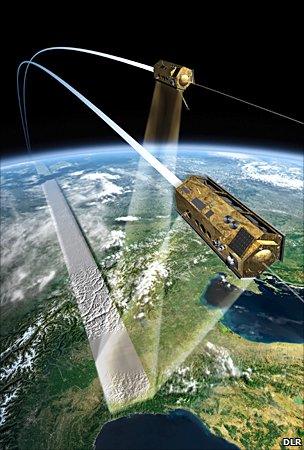
The satellites trace a helix across the sky as they move just a few hundred metres apart
It is a remarkable acrobatic display.
Two German radar satellites are now flying in tight formation as they prepare to make the most detailed ever 3D map of the Earth's entire surface.
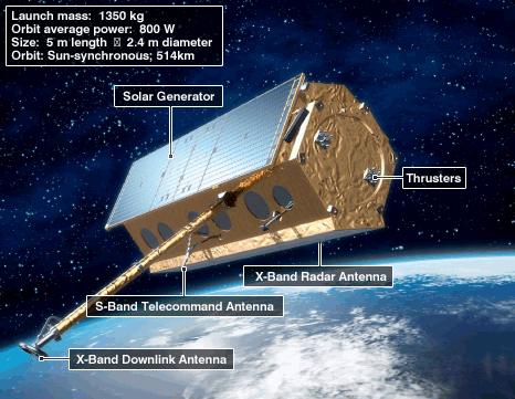
TanDEM-X and TerraSAR-X, external have moved to just 350m of each other as they sweep around the planet at 7km/s.
The pair will soon begin an intense observation campaign that will pin down the variation in height across the globe to an accuracy of better than two metres.
This digital elevation model (DEM) will be put to myriad uses - everything from improving the safety of aircraft navigation to understanding better which areas of ground are most at risk during a flood.
TerraSAR-X was launched in 2007. TanDEM-X was put in space in June, since when it has been brought closer and closer to its more established sibling.
The very close proximity manoeuvres were conducted step-by-step over the course of the past week.
"It's tricky and I must confess we've all been a bit nervous," Manfred Zink, from the German space agency (DLR), told BBC News.
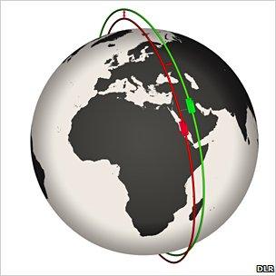
The orbits flown by the satellites are ever so slightly offset, which means they trace paths across the sky that look like the strands of a double helix. This should ensure they never bump into each other.
This operational flight profile is thought to be unique in civil space history.
Although vehicles approaching the space station, such as the shuttle, will frequently hold their position just metres away from the platform, this formation flying is very short-lived.
TanDEM-X and TerraSAR-X, in contrast, will spend the next three years turning about each other; and the current separation distance is not even the shortest planned. That will be just 200m.
"The closest will be adjusted when we are through the commissioning phase," explained Dr Zink, who is project manager for the TanDEM-X ground segment. "We hope that by Christmas we can finish all the various tests that are still outstanding, and to start the acquisition of the global DEM data."

The satellites' orbits are very slightly offset
The pair's radars work by constantly bouncing microwave pulses off the ground and sea surface. By timing how long the signal takes to make the return trip, the instruments can determine differences in height.
The compact orbital dance will give the pair "stereo vision", by enabling them to operate an interferometric mode in which one spacecraft acts as a transmitter/receiver and the other as a second receiver.
The fully finished DEM of the Earth's surface should be available in 2014.
Perhaps the best-known, near-global, space-borne DEM prior to the German venture came from the US Shuttle Radar Topography Mission (SRTM) of 2000. Its best product has a 30m by 30m spatial resolution, and a vertical resolution that varies from 16m to 10m.
With the TanDEM mission, the intention is to go down to a spatial resolution of 12m by 12m with a relative vertical accuracy of less than two metres.
Laser instruments (lidars) flown on planes can achieve better resolutions but their products are regional - they are not seamless maps of the whole Earth. TanDEM's will be.

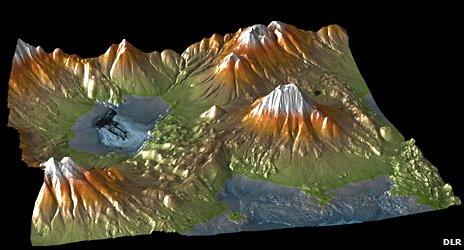
An elevation model shows the Aracar volcano on the Chilean-Argentinian border
"I think for the scientists, we expect that the TanDEM-X dataset will replace SRTM," said Dr Zink.
"You might know that SRTM is the most used Earth observation dataset ever. There is a version of it which is freely available on the USGS website. They have record hits. You have to imagine that all the people doing science around the Earth - be it geology, hydrology, whatever - for them, topography of the terrain is a key input."
The applications for digital elevation data were incredibly diverse, commented Dave Hodgson, the chairman of the British Association of Remote Sensing Companies:
"Consider just the leisure sector - if you're a skier then this would give you a better idea of the mountain terrain; if you're a computer games developer, this is going to give you a much more realistic world in which to play your game such as a flight simulator. This is all about adding the third dimension to our maps and we need more and more of it every day."
The TanDEM-X/TerraSAR-X venture is operated on the basis of a public-private partnership. The German space agency owns the hardware; EADS Astrium builds it; and Infoterra GmbH has exclusive rights to commercialise the data.
Responsibility for controlling the spacecraft falls to the German Space Operations Centre (GSOC) in Oberpfaffenhofen.

- Published26 June 2010
- Published21 June 2010
- Published9 June 2010