Antarctic ice sheet built from bottom
- Published

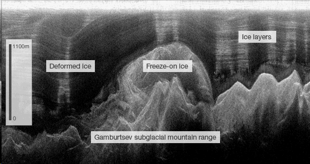
Radar reveals the ghostly shapes of the Gamburtsevs and the giant freeze-on "beehive" structure above
Scientists have seen once again just how dynamic a place the underside of the Antarctic ice sheet can be.
Survey data collected from the middle of the White Continent shows liquid water is being frozen on to the bottom of the sheet in huge quantities.
In places, this deeply buried add-on layer is hundreds of metres thick and represents about half of the entire ice column, researchers say.
The discovery is reported online in the journal Science, external.
Project leaders confess to being astonished by the findings.
"It's jaw-dropping, I have to say," said Professor Robin Bell from Columbia University's Lamont-Doherty Earth Observatory.
"The first time I showed the data to colleagues, there was an audible gasp," she told BBC News.
The new data will add to the understanding of how the ice sheet expands and moves, which in turn will inform researchers as they try to grasp how Antarctica might change in a warmer world.

Twin Otter planes criss-crossed the Antarctic interior with their instruments
The observations come from a major expedition to survey the Gamburtsev mountain range in the polar summer of 2008-2009.
Although similar to the European Alps in scale, the Gamburtsevs are hidden under kilometres of ice deep in the Antarctic interior.
An expeditionary team used instrumented planes to gather a wealth of new information about the peaks and their ice shroud.
Equipment included radar to see through the ice, showing its many layers, right down to the rock bed.
The survey data also gives new insights into how liquid water funnels through the mountains' valleys.
It is well known that ice sheets grow from the top down, as snow settles on the surface and is compacted over thousands of years.
But the new findings illustrate clearly how the sheet can also grow from the bottom up by accumulating layers of liquid water.
Sub-glacial water can be maintained in a liquid state at the bottom of the sheet, either by the intense pressure of the overlying ice or by being in contact with the warmth of the bedrock.
But if the water is forced up valley sides to locations of lower pressure, or into ponds in places away from retained heat in rocks, then it will rapidly turn to ice - and can stick to the bottom of the sheet above.
The survey data reveals that this add-on ice makes up 24% of the ice sheet base around Dome A, a 4.2km-high plateau of ice that represents the greatest elevation on the continent.
And in some other places, this refreeze phenomenon accounts for slightly more than half of the total ice thickness.
That means in these locations, ice is being created faster on the bottom of the sheet than it is being accumulated through snow deposition on the top.
New dimensions
Liquid water at the base of the sheet has long been recognised to be a "lubricant" for movement, but the latest data adds a whole new dimension to our understanding, said Professor Bell.
"We've known there's been melting under ice sheets from a long time - since the 1960s," she explained.
"Then it was demonstrated this water could move, it could slosh around; but I think we still had this idea that it just spilled into the ocean.
"Well, now we can show these hydrologic systems are modifying the fundamental stratigraphy of the ice sheet."
The discovery also has implications for the search for ancient ice.
Scientists are looking for a location to drill accumulated snow layers, because bubbles trapped in the layers retain information about the climate at the time of precipitation.
Currently, the oldest ice core climate record in the Antarctic extends back about 800,000 years.
Potentially, a core drilled from around Dome A could find ice that was laid down more than a million years ago.
The latest data could have a positive or a negative bearing on that search, said Dr Tom Jordan from the British Antarctic Survey.
"The new process we're observing suggests old ice could be pushed up towards the surface, which could make this very old ice that would give you a very long climate record much more accessible," he told BBC News.
"So instead of having to drill a three-kilometre core, the record might have been pushed to within a kilometre of the surface.
"That's the good news; but it's balanced against the recognition that in these places where we've found these structures, we may also be getting significant melting, deformation and destruction of ice sheet records.
"We'll have to choose a drill site very carefully; we can't just throw a dart in a board."
The Gamburtsev survey was a flagship expedition for International Polar Year (IPY), comprising scientists, engineers, pilots and support staff from the US, the UK, Germany, Australia, China and Japan.
The team established two field camps from which to mount the airborne campaign.
As well as the ice-penetrating radar, other instruments measured the local gravitational and magnetic fields.
Some 120,000km were flown in total, the equivalent of three trips around the globe.
More than 20% of the East Antarctic Ice Sheet was explored.