Met Office model 'better at predicting extreme winters'
- Published

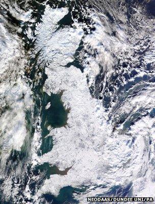
The 2010/2011 winter saw the UK gripped by sub-zero temperatures for days
UK weather forecasters can predict cold winter weather a season ahead with more confidence, according to analysis of a new computer model.
Writing in Environmental Research Letters, external, scientists say the model is better at simulating phenomena known as sudden stratospheric warmings (SSWs).
These happen when the usual westerly winds at 10-50km altitude break down, causing cold weather on the surface.
Developers at the Met Office say it is an incremental advance for forecasts.
Seasonal forecasting is still in its relative infancy, but the report's authors from the Met Office say that improving their ability to represent SSWs is a help.
When the stratospheric westerlies break down, it generates a signal that typically burrows down to the Earth's surface over following weeks.
This hampers surface westerlies that bring mild air to northern Europe from the Atlantic and allows Europe to get blocked in a cold state.
'High-top' modelling
The model, known as GloSea4, simulates winds, humidity and temperatures from the Earth's surface to 80km (50 miles) high - beyond the stratosphere. Data points on the old low-top model were capped at 50km.
Adam Scaife, head of long-range forecasting at the Met Office, said: "SSWs happen every couple of winters and about 70% are associated with cold air over Europe.
"Raising the lid of the model has been an improvement in our ability to simulate them," he told BBC News.
Dr Scaife added that SSWs were still poorly understood but were linked to sudden increases in temperature of up to 50C (90F) over a few days in the stratosphere over the Arctic. The temperature changes cause winds to reverse their normal direction.
The high-top model was not available to the Met Office before the bitter winter of 2009/10, and they could not forecast sufficiently far ahead the arrival of the cold that resulted in the UK grinding to an unprepared halt in the snow and ice.
Retrospectively, using the high-top model with atmospheric data available from autumn 2009, the Met Office said that they could have seen the cold coming farther ahead if they had been able to use the new model.
Lead author Dr David Fereday said: "This is an advance for us because it means that in certain situations we can give better estimate of risk for government planning."
The high-top model was devised in time for the winter of 2010-2011.
Using its data, the Met Office forecast in autumn 2010 that there was a 40% chance of a cold start to the winter, with a 30% chance of a mild start, and a 30% chance of an average start.
The summary of the advice to government said: "There is an increased risk for a cold and wintry start to the winter season."
The probability of cold increased to 45% as November started.
And the heavens indeed despatched the UK a brutal blast of cold, plunging Wales into its lowest-ever recorded November temperature of −17.3C (0.9F) in Llysdinam.
No 'silver bullet'
This was clearly an advance in forecasting from the previous year. But it still was not sufficiently robust for the authorities.
Forecasting a 40% chance of a cold winter still meant a 60% chance of a mild or average start to winter.
An unverified blog at the time quoted a civil servant commenting: "The Met Office seasonal outlook for the period November to January is showing no clear signals for the winter."
The Met Office no longer publicly publishes a seasonal forecast for winter but their annual three-month rolling forecast for December to February will go to policymakers in November.
Met Office spokesman Dave Britton said: "We don't want to over-egg GloSea4 high-top. It's moving us one piece forward in the very complicated jigsaw behind the weather.
"It's not a silver bullet - for instance SSWs are not responsible for every episode of cold weather that we get - but it is an advance," he told BBC News.
Judah Cohen, director of seasonal forecasting at the US-based Atmospheric and Environmental Research (AER), observed:" The research is potentially very important. Winter forecasting remains a difficult challenge and much work is needed to improve our forecast models.
"The Met Office have shown great creativity in exploring gaps in our knowledge and deficiencies in the models. But frankly, the bar for seasonal forecasting is set pretty low so any advance is very welcome."
Follow Roger on Twitter: @RogerHarrabin, external
- Published31 January 2011
- Published3 December 2010