Mars rover: Wide and in the open
- Published
- comments

Rover and key target - Mount Sharp: In many ways, it's an image that defines the Curiosity mission
One of the welcome features of several recent space missions has been the decision to post pictures online almost as soon as they come down to Earth.
If you dig around the mission websites, you can find their "raw images" sections.
These indexes can be a little confusing to the uninitiated because the pictures rarely come with clear caption material, and you're not always sure what you are looking at. But I promise you, it can be a rewarding time browsing the unfiltered vistas from far-flung worlds. You'll often see things that only get mentioned by the big news organisations days later when they're given one carefully selected shot to publish.
And in the case of the Mars rover missions, these raw collections, external also allow anyone with the right software to start to build their own panoramas of the Red Planet.
I wanted to draw your attention to the work of Ken Kremer, external, a freelance science writer whose work can often be found at Universe Today, external, but at many other publications as well. Ken, with colleague Marco Di Lorenzo, has built a number of panoramas of Gale Crater that give us a wider perspective on the Curiosity vehicle's Martian home - literally.
The image at the top of this page was built from pictures acquired by the rover on the 85th Martian day of its mission (the middle of last week).
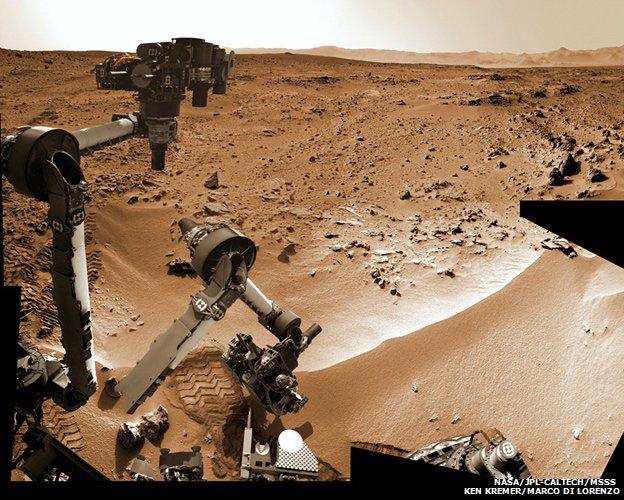
The self-portrait was stitched together from images captured by the "hand lens" on the end of the vehicle's robotic arm.
The large rise in the background is the big mountain in the centre of Gale Crater known as Mount Sharp. It is at the base of this peak that the rover expects to find some of the most interesting rocks during its mission, although it will be many months before it gets there.
It's a great panorama because it reminds me of those holiday pictures we've all taken with the landmark over the shoulder. "Wish you were here!"

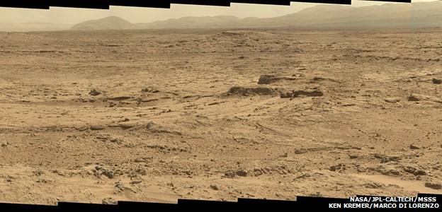
Glenelg has become a familiar name in recent weeks. It will be the site of the first drilling action
One of my favourite panoramas from Ken is the one he's put together of Glenelg.
If you've been following the Curiosity mission you'll know this location was selected as the first prime science destination - it's where satellite imagery has indicated there is a junction of three distinct rock terrains.
Curiosity will trundle around this patch of ground looking for a candidate rock in which to drill. That activity should take place in the next few weeks.
You can follow Ken Kremer's work at his website, external. His pictures will also be featured in the PBS NOVA documentary on Curiosity called Ultimate Mars Challenge, external, which airs in the US next week on Wednesday (21:00 ET/PT), external.
And let me recommend, too, the Opportunity Mars rover's raw section, external, and that of the Cassini Saturn orbiter, external. The Cassini site has a useful FAQ, external that explains some of the oddities of wading through such collections.
And if you want to see what others are up to in terms of "citizen image processing", drop by the online forum unmannedspaceflight.com, external. Lots of mosaics are being shared there.

This mosaic captures the action of the rover's robotic arm as it moves to scoop the Martian soil
