Legacy of Britain's great flood
- Published
- comments

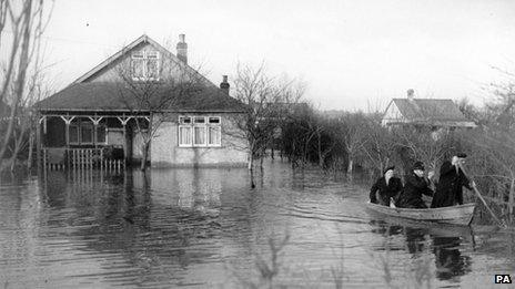
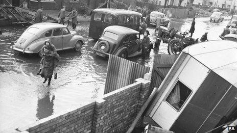
The 1953 flood caused widespread damage across Eastern England
A grim saga of ignorance and incompetence that allowed a vicious storm to kill more than 300 people is remembered in dozens of coastal communities today.
A huge surge of water swept down the North Sea on 31 January 1953, pulverising the east and south-east coasts of England in an onslaught with powerful echoes even now.
That national trauma 60 years ago - one of the worst peacetime disasters in British history - still guides research into the dangers of coastal flooding and the efforts to manage defences against it.
Back then the shoreline was largely undefended with few barriers to hold back the exceptionally high waters. Only central London, guarded from the Thames by a series of embankments, had any serious protection.
The Met Office was in operation, but it had no system for forecasting the coincidence of weather, waves and tides that would give the sea such overwhelming force.
Even as towns and villages and farms were hit, one after another, the various authorities lacked any kind of coordination so no information was passed on or warnings given.
As the people of Lincolnshire and East Anglia were coping with the shock and misery of lost lives and devastated homes, households further south - in the Thames Estuary - went to bed with no clue that the deadly waters were heading their way.
Death toll
The final death toll of 307 led to an entirely new perception of the risk the sea could pose to an island nation. The distinctively shiny shapes of the Thames Barrier are the most tangible result.
Storm surges have the potential to be dangerous because they involve a great upwelling of a stretch of ocean - intense low pressure at the heart of a storm literally tugs the sea surface above its normal level to create a massive bulge. In 1953 this stood several metres high.
The surge then acts as an elevated platform on which the winds of the storm whip up waves that can be reach much higher than usual. If this coincides with a high tide, the risk can become extreme.
Geography provides an exacerbating factor: where the North Sea narrows into the English Channel, the waters are funnelled towards the English and Dutch coasts. In the Netherlands, where large areas are below sea level, the 1953 surge killed more than 1,700 people.

King's Lynn was under water
While the flash floods caused by intense rain tend to be localised and flooding from rivers usually comes with plenty of warning, coastal inundations can be far-reaching and violent. As one government emergency planner once told me, "it's storm surges that really worry me."
So what lessons have been learned? Most significantly, forecasting has improved beyond all recognition. The 1953 storm struck before the space age. Satellites now keep watch on the weather systems and computer models calculate whether the conditions are right to create a surge.
A network of monitoring stations around the coast provides minute-by-minute data on the height of the sea. And the Met Office, Environment Agency and other bodies not only talk to each other but also work together on a system of warnings. The emergency services and local authorities are involved in preparations.
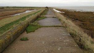
The 1953 produced a massive physical response as well: beyond the Thames Barrier, a network of hundreds of miles of sea walls now stands against a rising sea.
Populations at risk
With budgets tight or declining, only London gets the highest standard of defence and winning new or improved protection can be quite a battle for many communities.
But while the coast is immeasurably better guarded than it was 60 years ago, the population living close to it has soared.
More people and more economic value need protecting than ever before. For example Canvey Island, which saw a terrible loss of life in the flood, has three times more people than 60 years ago.
And the shoreline itself has changed. The south-east corner of Britain is gently subsiding while the sea is rising, as it warms, so the relative level of the sea is increasing.
At one stretch of shoreline in Essex, it is now 10cm higher than it was in 1953 - the kind of rise that could make the difference between a flood defence holding or being overwhelmed.
Given the cost of building ever larger sea walls, there is an attempt to harness Nature's own defences. The Dutch call it "making space for water".
Dr Iris Moeller of Cambridge University and her colleagues, study those often-forgotten features of our coastline, the salt marshes. Working on a project known as CBESS, external funded by the Natural Environment Research Council, they have calculated that waves lose about half of their energy when they pass over just ten metres of marshland.

Flood defences were established in the aftermath of the flood
"Each wave is like a hammer stroke beating on a sea wall which starts to make it crack and then we have to repair it," she says. "But when we have a salt marsh, it takes away the power of those hammer strokes so the wall can be more cheaply made."
If spending on defences remains limited, and the scenarios for sea-level rise through climate change prove correct, conservation of the marshes may acquire more urgency.
So are we safer than in 1953? Definitely, according to the Environment Agency. But its officials find themselves torn between wanting to reassure people that the threat is under control and reminding us all that no defence is perfect.
The man in charge of London's protection, Andy Batchelor told me: "You can never say never - there is always going to be the tide that may overtop or may cause problems. I'm not scaremongering but it's about people needing to be aware."
As we stand in the Thames Barrier control room, computer screens tracking the waves out in the North Sea, I ask him about the value of remembering the catastrophe of 1953.
His reply? "To remind us to guard against complacency."