Ferocious winds drove Tacloban surge
- Published

The destruction in Tacloban City on the Philippines' east coast has been described in terms that are reminiscent of recent great tsunamis - of buildings and people being swept away by a huge wall of water.
The cause is very different, of course. For tsunamis, the wall arises from an earthquake's displacement of the sea floor. In the "storm surge" that Tacloban and surrounding towns experienced, it is primarily the ferocious winds that create the unstoppable mass of water.
Several factors, though, have to come together to make the kind of phenomenon witnessed in the Philippines.
One is an extreme zone of low air-pressure, which allows the ocean to rise up.
For Typhoon Haiyan, the meteorologists were talking of 895 millibars - 100 millibars or so below what one would normally expect.
But this in itself would probably have raised the water by no more than a metre.
The winds, on the other hand, had a huge impact. They were estimated to have reached an average of 310km/h (195mph) as the storm centre made landfall.
Such force would have pushed the water even higher, particularly on the northern side of the typhoon's eye where the winds move in the same direction as the storm.

And unfortunately for Tacloban and nearby settlements, the storm followed a track that put the area full-square in the firing line.
The local geography and the shape of the sea floor would also have exacerbated the effect.
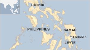
As the surge neared, it was funnelled into the bay between the islands of Leyte and Samar. The water rose so high as it came across the coastline that even those who took refuge on the first floors of buildings were swept away.
The estimates are uncertain, but the storm surge that hit Tacloban was at least two metres high and there are reports of waters reaching in excess of five metres (16ft) in places.
The forecasts were pretty good in the run up to Typhoon Haiyan. They benefitted from the plethora of satellite data now available and the advances being made in computer modelling.
Those models were giving hints of a big storm in the region some 12 days in advance.
By seven days in advance, it was fairly certain there would be a storm crossing the Philippines, and by four days out the tropical cyclone even had a name.
However, forecasting intensity - especially of those winds - is a more difficult game, but one in which the meteorologists believe they are gaining much improved skill.
"We're now running higher resolution models over this region, down to about 4km resolution, and they are doing a lot better at forecasting storm intensity," explained Julian Heming, a tropical prediction scientist at the UK's Met Office.
"We're actually working on a collaborative project with the Filipinos at the moment.
"This is where we need to focus on in the future, to get a handle on intensity because that's where the advances need to be made."
Jonathan.Amos-INTERNET@bbc.co.uk and follow me on Twitter: @BBCAmos, external