Apple aerial map photos blocked over Oslo in Norway
- Published

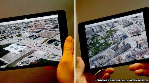
Oslo (left) is visible in 2D on Apple's map but Danish capital Copenhagen (right) is in 3D
Norwegian officials have confirmed they are refusing to let Apple take aerial photographs of Oslo to create 3D images for its Maps app.
Anyone wishing to fly over the capital to take pictures requires a licence from the authorities,
Norway's National Security Authority said it had security concerns, but added there were other ways the tech firm could get the data it wanted.
Other map brands have used flat satellite images for their services.
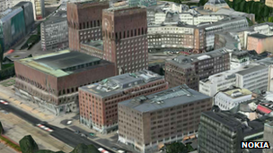
Nokia also has 3D-images of Oslo's buildings in its Here product but only for parts of the city.
News of the denial was first reported by the local newspaper Aftenposten. It said officials were worried about the public having access to detailed views of government buildings.
Security measures have tightened in Norway since Anders Breivik planted a bomb outside government premises in Oslo before carrying out a killing spree at an island youth camp two years ago.
"There has been a major debate in Norway about security since the shootings, including how secure government offices should be," Henning Carr Ekroll, a security reporter at national newspaper Aftenposten, told the BBC.

Nokia has 3D images of parts of Oslo
"That applies both to physical security but also to aerial photography.
"The government is unable to do anything about satellite images but you still need permission to fly and you get higher definition pictures from a plane."
However, a spokeswoman for Norway's National Security Authority indicated there might still be ways for Apple to add a Flyover view of Oslo to its app.
"It is correct is that we have denied Apple the possibility to take air photos over the Oslo area," she told the BBC.
"The reason is that there are restriction areas in this region. We have suggested alternative ways to get the images it wants, as we generally do to be flexible.
"One way would be to contact a Norwegian supplier who already has a licence. Another way would be to just buy the needed mapping from the Norwegian Mapping Authority."
Norwegian companies such as navigation website Gule Sider have previously been allowed to take aerial pictures but there are gaps in the content available on the site, Mr Carr Ekroll added.
"If you search for Oslo you won't get details in particular areas. But they did take photos from aeroplanes," he said.
"It's easier for Norwegian operators to get licences because [the ministry] can have more control over the photos."
Aftenposten points out that neither the US Department of Defense in Arlington or the CIA headquarters at Langley are currently available in 3D on Apple's maps.
A spokesman for Apple was unable to provide comment at this time.
- Published15 May 2013
- Published20 September 2012
- Published11 June 2012