Drivers warned as more snow and ice forecast for UK
- Published
Snow and record low temperatures have left some people without power and struggling to keep warm
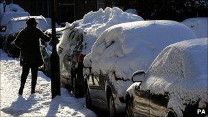
Drivers across the UK are being warned to take extra care as the working week begins amid further heavy snow and ice.
Parts of eastern England and Scotland already under thick snow could get up to 25cm (10in) more by Monday morning.
Plummeting temperatures overnight will lead to icy roads in many places, while strengthening winds will cause snow to drift and make it feel even colder.
Motoring organisation the AA is warning commuters to take great care, even on major roads that have been gritted.
The UK has been experiencing the earliest widespread snowfall since 1993.
On Saturday night temperatures in Wales and Northern Ireland fell to the lowest on record for November, reaching -18C (0F) and -9.5C (15F) respectively.
Wind chill
Met Office severe weather warnings , externalfor heavy snow are in place for eastern and central Scotland, and eastern England from the Borders down to the East Midlands.
There are early warnings of more to come on Monday and Tuesday, with eastern counties again the most at risk.
BBC weather forecaster Liam Dutton said: "One thing that will be new on Monday is the wind.
"It will be really quite strong, so significant wind chill will be an issue. Even where there isn't new snow, what's there already will be blown about and roads that have been cleared could be covered up again.
"Towards the middle part of the week we could also start seeing snow in places that haven't had any up to now like the south east of England."
Drivers in the worst-hit areas are being asked to consider whether their journeys are really necessary and, if they do venture out, to take extra care.
Motoring organisation the AA said it had experienced "virtually unheard of" numbers of call-outs on Sunday and spokesman Gavin Hill-Smith said they it was expecting even more on Monday morning.
"A lot of cars haven't been used over the weekend, but when people come to go to work or school on Monday they'll find the battery is flat or they can't get out of the drive," he said.

The AA is warning that many drivers could struggle to start their cars on Monday due to the cold
"The worst places so far have been those with the very lowest temperatures, especially Wales and eastern Scotland, but really everywhere in the UK is affected."
He warned people to take extra care: "The main concern is always ice. People must not get complacent - even on major roads that have been treated patches of ice can still develop.
"They also need to leave themselves extra time in the morning - for the drive itself and to make sure the car is completely clear of snow and ice before they set off."
A 40-year-old man was seriously injured in a crash on the M1 near Sheffield on Saturday morning. His car skidded off the carriageway after hitting a patch of ice, and he was struck by another vehicle when he stepped out onto the hard shoulder.
Salt warning
A number of airports, including Edinburgh, Glasgow, Derry, Newcastle and Durham-Tees Valley, were affected over the weekend and disruption is likely to continue on Monday.
Rail and bus services in parts of Scotland and north-east England are also likely to face further problems.
Ian Mercer, who runs a company which provides salt for gritting to schools, hospitals and shopping centres, said he feared that supplies could be stretched to breaking point this winter.
"People are being much more proactive," he told the BBC. "Last year was the busiest ever, but we've already sold twice as much this year and it's not even December.
"We've had to import salt from places like Russia, Egypt and Sardinia but even there it's becoming more and more difficult to source.
"If it continues to be this cold beyond Christmas I think there will be really serious shortages."
The unusual weather is being caused by high pressure over Greenland and low pressure in the Baltic states, forcing cold winds from the north-east across Europe.
- Published28 November 2010
- Published28 November 2010
- Published28 November 2010
- Published28 November 2010