UK heatwave: Hottest day for seven years recorded
- Published

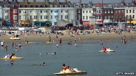
Crowds flocked to the beach, including in Weymouth, Dorset, (pictured) as temperatures reached record levels
The UK is experiencing its hottest day since July 2006 as the heatwave continues, BBC forecasters have said.
A temperature of 33.5C (92.3F) was recorded at Heathrow and Northolt in west London.
The highest UK temperature recorded before Monday was 32.2C at Hampton Waterworks, south-west London, last Wednesday.
The hot weather is expected to give way to thunderstorms and potential flooding on Monday night.
The BBC Weather Centre said delayed reports from smaller weather stations could produce a higher reading than 33.5C.
A spokesman added that it was also possible the record for the highest minimum overnight temperature - Brighton's 23.9C in August 1990 - may be broken.
Before Monday the highest temperatures recorded this year in the UK - but outside England - were 30C at Auchtermuchty, in Fife, last Thursday; 30.1C at Castlederg, in Strabane, on Friday and 31.4C at Porthmadog, in Gwynedd, on Friday.
A high of 36.5C was recorded at Wisley, Surrey on 19 July 2006 - and that month was the warmest on record over much of the UK.
'Unstable atmosphere'
BBC weather forecaster Mike Silverstone said south-east England was seeing the hottest of Monday's weather.
The heat across the Midlands, East Anglia and north-east Wales could trigger thundery showers, which is likely to filter down towards the north London area later.
"Essentially, today the atmosphere high up is starting to cool off, but at low levels it is warming, and this is creating an unstable atmosphere," he said.
"The atmosphere likes to be in balance, and because warm air is less dense than cold air, the warm air will rise. The air parcels will keep rising until they encounter air which is warmer than them.
"Once this rising air becomes saturated, clouds start to form... The result will be isolated storms, producing some heavy rain and localised flooding where they occur."
But he said some parts of the UK were escaping the heat - north-east England and south-east Scotland were cloudy and cool.
'Heatwave action'
The Met Office's heatwave alert system is at level three - "heatwave action", external - indicating there is a 90% probability of heatwave conditions until 21:00 BST on Tuesday in parts of England.
Eastern and south-eastern England, and London, are expected to exceed thresholds later on Monday and overnight, it said.
In the four years since the system was introduced, the Met Office has never used its top - level four -category, which is a "national emergency".
The UK is witnessing its first prolonged heatwave since 2006 - though Saturday was the first day in seven when temperatures did not exceed 30C anywhere in the country.
Jay Wynne explains where and when the hot dry weather is expected to break
The hot weather has caused some problems, with grass fires in some parts of the country, including in Scotland and Epping Forest in east London.
But the current heatwave has not matched the summer of 1976, when temperatures above 32C (89.6) were recorded on 15 consecutive days.
The highest temperature in UK history was 38.5C, recorded at Faversham, Kent on 1 August 2003.
- Published19 July 2013
- Published18 July 2013
- Published12 July 2013
- Published21 July 2013
- Published20 July 2013