UK weather: Why has it been so wet?
- Published
Nick Miller: "It's a weather pattern which has been relentless so far this winter and is set to stay with us into February"
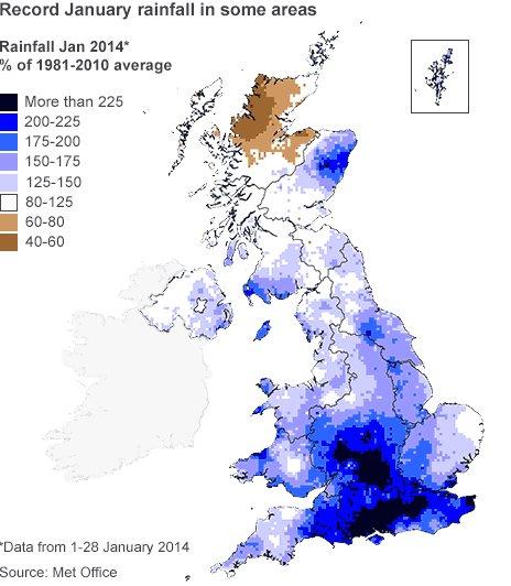
As figures suggest parts of England have had their wettest January on record, BBC meteorologist Nick Miller explains what caused all the rain.
Perhaps people who live in northern Scotland are getting fed up hearing about how wet it is because this is the one part of the United Kingdom that hasn't received its normal January rainfall.
Elsewhere it's been a month of soaking rain - historically so in south-east England, where in records going back to 1910 you can't find a wetter January.
In South Wales and south-west England, the last time January was wetter than this one it was 1995 and East 17 were at number one in the charts.
The Met Office says that all parts of the UK are on target for a wetter than normal winter.
'Relentless weather'
And it hasn't just been wet, it has been mild too. Up to 28 January, the UK's mean monthly temperature was running 1.2C above the long-term average.
To find one of the causes of this mild, wet winter you need to cross the Atlantic to North America, in the grip of an extremely cold and snowy winter.

In the atmosphere above North America, the sharp contrast between the Arctic air and the warmer air it clashes with on its journey south, has strengthened the jet stream and the weather systems that travel along it to our shores.
The jet stream is a fast-moving ribbon of winds high in the atmosphere and when it is strong and coming right for us then our weather turns stormy.
It's a weather pattern that has been relentless so far this winter and shows no sign of letting us loose from its grip, even into February.
.gif)
All of this might just be down to the UK weather's natural variability. It seems to like going from one extreme to another. This time last year there was plenty of snow around and more was to come in March.
But there might be another reason the jet stream is behaving as it is - the quasi-biennial oscillation or QBO for short.
This is a cycle involving a band of winds high above the equator. Every 14 months or so these winds switch from easterly to westerly.
The Met Office believes a westerly phase is more likely to produce stormy winter weather in the UK. There has been a westerly phase since early last year.
The humbling thing about weather is that we still don't have all the answers.
But before you think it's game over for cold and snow this winter, don't forget how cold it was last spring.
Two consecutive cold springs would surely stretch belief but if we've learned one thing about our weather it's to expect the unexpected.
- Published30 January 2014