UK storm brings heavy rain and high winds
- Published

A number of lorries have blown over on the Woodhead Pass in the Peak District where winds reached up to 100mph
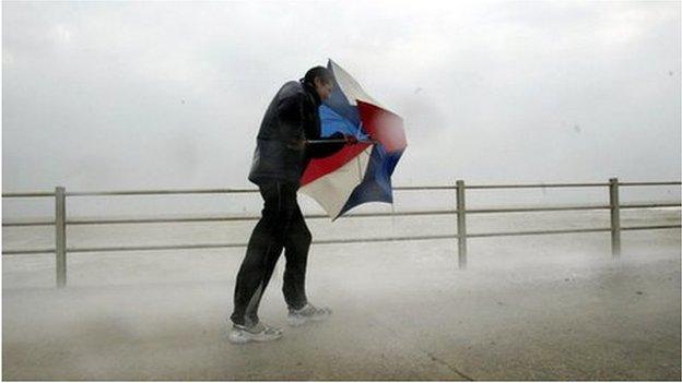
The "remnants" of the storm that brought severe blizzards to the US is hitting parts of the UK, bringing heavy rain, gales and travel problems.
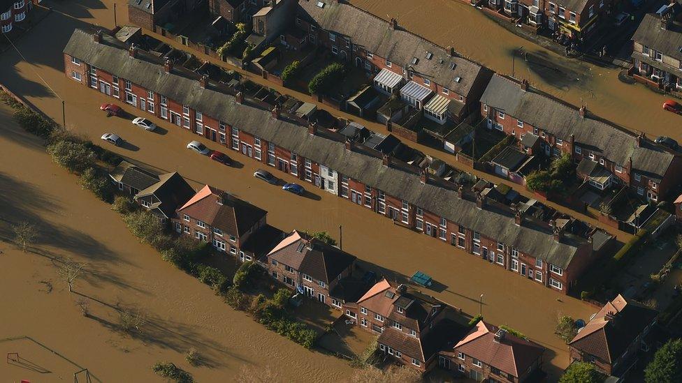
Western areas have borne the brunt, including Cumbria, where some schools have closed and roads are flooded.
Ferry services to the Scottish Islands remain disrupted, and in Edinburgh a man was hurt when a broken chimney smashed through a bus window.
The Army is working to help shore up defences in some high-risk communities.
The Met Office has issued yellow - be aware - warnings, external for rain and there are more than 120 flood warnings and alerts, external in place across England and Wales.
A first band of heavy rain and high winds is now moving south and east, but a second band is forecast to arrive from the west overnight into Wednesday.
Among the main developments:
Pupils and staff were rescued by boat after their primary school in Aberfoyle, near Stirling, was cut off by flooding
Gales have blown over a number of lorries, including on the A1 northbound at Dunbar in East Lothian and on the Woodhead Pass, in the Peak District. The pass is now closed as winds are reaching up to 100mph
Hundreds of homes across Wales have been hit by power cuts
Ferries services between the mainland and the islands of Scotland are also disrupted
Some rail lines have been affected by flooding, including in Cumbria and Ayrshire
Some schools have closed in Keswick, one of the places worst hit by the storms last month
The Environment Agency says it has teams on the ground in Appleby, Keswick, Cockermouth and Glenridding, as well as in Mytholmroyd, Hebden Bridge, Calderdale and York

This image sent to BBC Weather Watchers shows waves crashing over the sea wall at Porthcawl on Tuesday morning

The Glenridding Hotel in Cumbria has flooded for the fourth time this winter - debris still lies scattered in the garden from the last inundation
The heaviest rain on Tuesday was over Cumbria and south-west Scotland, with the Welsh hills and the moors of south west England affected to a lesser degree.
Shap in Cumbria saw about 50mm (2in) of rain, while 12-25mm (0.5-1in) fell in other areas.
After a brief dry spell, more rain is to come on Wednesday, with yellow warnings in place for much of Northern Ireland, Scotland, Wales and western and southern England.
'Already saturated'
Environment Secretary Elizabeth Truss said the Army was helping to build temporary defences in areas at risk of flooding and more military personnel were on standby.
"The real issue for us is the cumulative effect of a series of rain fronts falling on ground already saturated," she told the Environment, Food and Rural Affairs Committee.
The Environment Agency has 11 flood warnings, external in place, meaning flooding is expected: three are in Cumbria, five are in Dorset, and there is one each in Conwy Valley, North Yorkshire and Carlisle.
There are also more than 110 flood alerts - meaning flooding is possible - in England and Wales.
The agency said rivers in Cumbria, Lancashire and Yorkshire were already at record levels following the wettest ever December. There was also a possibility of "some flooding" along the rivers Severn and Wye.
The Scottish Environment Protection Agency (Sepa) currently has nearly 30 flood warnings and nine flood alerts, external in place.

The Environment Agency is warning people to take great care on coastal paths and roads, like this one in Trearddur Bay

Water is pouring off the hillsides in the Lake District, making journeys difficult
BBC forecaster Steve Cleaton said very strong winds in south-west Scotland, in particular, could make for "quite awful" conditions early on Wednesday.
There could also be significant snowfall overnight north of the central belt of Scotland, he added.
Thursday looks to be a quieter day, but more yellow warnings for rain have been issued for Friday.

This satellite image shows the storm system moving in from the Atlantic and sweeping over the UK

The Army is helping shore up flood defences in Mytholmroyd, West Yorkshire - one of the places worst hit last month

The wind got the better of one trampoline in Abbey Wood, Greater London
Live flood warnings from the Environment Agency and the Scottish Environment Protection Agency.
View the flood map by tapping on the image below

Tap here, external for up-to-date flood information.

Tap here, external for up-to-date travel information.
- Published25 January 2016
- Published5 January 2016