UK weather: Snow and ice warnings as cold blast to continue
- Published

Yellow rain and snow warnings are in force across many parts of the UK, with a blast of cold weather set to continue on Friday.
"We've had the worst of it but it's still not completely clear," said the Met Office's Dan Stroud.
On Friday, warnings for snow are in place in northern England, Northern Ireland and Scotland, with a rain warning in southern England.
A warning for snow and ice is in place across central and northern Scotland.
It comes after dozens of schools closed and major travel disruption was reported on Thursday.
About 10cm (3.9in) of snow was measured by the Met Office in Kirkwall, Orkney, Scotland, on Thursday. The coldest temperature recorded was -13.8C (7.1F) in Altnaharra in the Scottish Highlands.
There was also heavy rainfall, with 43.2mm measured in Harbertonford, South Devon, almost half of the average the area usually sees in February.
Watch: The latest weather forecast with Carol Kirkwood
In Flintshire, north Wales, every school was shut before any snow had fallen, which prompted a backlash from frustrated parents. Flintshire council has apologised for disruption caused.
School closures have also been reported in Wales, Yorkshire, Derbyshire, Staffordshire and Cumbria.
North Wales Police reported several reports of minor road traffic collisions.
There were road delays and disruption to rail travel. There was disruption reported by Great Western Railway on the line between Bath and Swindon due to flooding.
There were significant delays at London's Euston station, though London Northwestern Railway said this was partly caused by a swan on the line.
The Met Office has warned that untreated pavements and cycle paths are likely to be impassable, with injuries from slips and falls likely on icy surfaces.
The weather situation has been complex across the UK, with big differences in conditions depending on how high you might be above sea level.

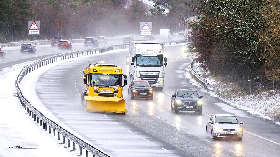
A snow plough near Dunford Bridge, South Yorkshire

A snowy wood in Thurlstone, Barnsley

A snow covered street in Kirkby-in-Ashfield, Nottinghamshire
Away from high ground in north Wales and northern England, there is still likely to be a spell of snow falling that could bring other travel disruption, especially around the morning commute.
The amount of snow here though can depend on a number of different factors and may vary across relatively short distances.
For many, even though there could temporarily be snow falling, it is more likely that sleet or rain will be mixed in.
This will be more the case through Thursday afternoon as the area of rain, sleet and snow moves north into southern Scotland and Northern Ireland allowing milder air to spread north.

Friday's weather warnings
There are also a number of yellow warnings spanning in the following areas:
A warning for rain is in place for much of southern England and parts of south Wales where periods of heavy rain are expected from 02:00 GMT on Thursday until 06:00 on Friday
A snow warning covers much of northern England, north Wales and the Midlands from 06:00 Thursday until 06:00 on Friday
A snow and ice warning covers the most of Northern Ireland from 09:00 on Thursday until 06:00 on Friday
A snow and ice warning is in place for central and southern Scotland from 18:00 on Thursday until 15:00 on Friday
Into Thursday night and Friday morning, snow will fall more into Scotland, accompanied by strong winds.
Heavy spells could also be possible as temperatures rise in England and Wales.
The UK's cold weather comes as the EU's climate service says global warming for the first time has exceeded the 1.5C warning limit across an entire year.
World leaders promised in 2015 to try to limit the long-term temperature rise to 1.5C, a target seen as crucial to help avoid the most damaging impacts.
Urgent action to cut carbon emissions can still slow warming, scientists say.

How are you preparing for the snow and ice? Share your experiences by emailing haveyoursay@bbc.co.uk, external.
Please include a contact number if you are willing to speak to a BBC journalist. You can also get in touch in the following ways:
WhatsApp: +44 7756 165803
Tweet: @BBC_HaveYourSay, external
Please read our terms & conditions and privacy policy
If you are reading this page and can't see the form you will need to visit the mobile version of the BBC website to submit your question or comment or you can email us at HaveYourSay@bbc.co.uk, external. Please include your name, age and location with any submission.
Related topics
- Published3 January
- Published7 January
- Published6 January
- Published8 February 2024