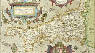
First maps of Cornwall sell at Bonhams for £46,000
- Published

Produced in 1576, the first printed map of Cornwall went for £10,000
A collection of more than 80 historic maps of Cornwall and the Scilly Isles has been sold at Bonhams for £46,000.
Among the highlights was the first printed map of Cornwall from the first county atlas of England and Wales, produced in 1576 during the reign of Elizabeth I.
The detailed map was sold for £10,000 against an estimate of £6,000-8,000.
Bonhams senior book valuer John Walwyn-Jones said he was "not surprised they attracted so much interest".
The maps had been collected over a period of 40 years by Peter Dewhurst who was brought up in Bodmin.
He emigrated to Southern California in the 1960s where he has lived ever since.
Mr Dewhurst, now in his 70s, said: "I am happy to know that the maps and charts which have given me so much pleasure over the years will be enjoyed and studied by new owners in new places."
Mr Walwyn-Jones said: "This was an outstanding collection of maps which had been put together with great care and discrimination."