Tracing the hidden River Sherbourne under Coventry
- Published

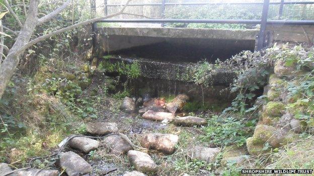
The River Sherbourne is channelled into a concrete culvert between high rise flats in Coventry's Spon End
BBC News follows the hidden River Sherbourne, covered by city centre development, that a report claims could be worth £1.5bn for Coventry.
Crouching between a high rise estate and a busy dual carriageway, the slow-flowing river looks nondescript until it comes to a large caged concrete tunnel, thrusting under the city's ring road.
This is the where the River Sherbourne, once vital for early settlers, disappears from view and becomes a hidden river: contained, covered and contaminated.

Aecom and Severn Trent Water's report suggested uncovering the River Sherbourne in four city centre sites would have economic and environmental benefits
Historians believe the river was much larger in Anglo-Saxon times and would have supplied fish and drinking water to small hamlets in the Forest of Arden, the forerunners to Coventry itself.
Despite its current condition, classified by the Environment Agency as "poor" (or two out of five for quality), some believe the Sherbourne could be liquid gold for tourism in the regenerating city.
The river, which disappeared into a culvert under city centre development in the 1960s, could be worth £1.5bn in flood action savings and increased property prices and business investment, according to a Defra-funded report by Aecom, external.

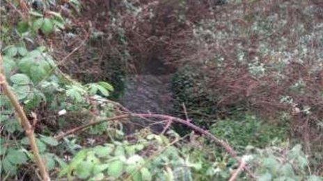
The River Sherbourne briefly reappears in the city centre, in an undeveloped area behind Cross Cheaping shops
The River Sherbourne makes a brief reappearance in the city centre, among the bins and back doors of shops behind Cross Cheaping, where its rotten smell, like damp decomposing cabbages, unmistakably rises from its murky flow.
Aecom, whose research was commissioned by the government's technology strategy board, estimated it would cost about £3.3m to open up a central section of the river, making it visible to tourists and residents.
"By allowing green infrastructure to do a proper job in a city, you make it a nice place... and the buildings around rivers enjoy higher property values," said Michael Henderson, its associate director.

The River Sherbourne exits the city centre, under Far Gosford Street, after suffering from lack of light and oxygen, according to the report
The report identifies four places to uncover the river, saying it would attract people and business to the city centre, "create excellent public realm and walking routes" and improve the water quality of the light and oxygen-starved hidden water.
Early maps show the river, which starts north west of the city near Corley, was steadily controlled and covered throughout the 20th Century, before the city's post-war rebuilding hid it almost completely.

Historic Coventry author Rob Orland has traced Coventry's development over The Sherbourne since 1225
Colin Walker, from the Coventry Society, said: "Coventry almost certainly owes its founding and development largely to the river. While we now dismiss it as not much more than a sewer, in medieval times it was a very useful tool.
"The six monasteries... all ran sheep and processing the wool made Coventry a very rich city."
One of the society's other members, Paul Maddocks, champions the idea of opening up the city centre river and, in 1995, drew up a plan to present to the council.
His idea was to use the river as a centrepiece in a pedestrian square and industrial heritage quarter, but he failed to win backing from councillors.

Former Transport Museum employee Paul Maddocks designed a scheme for opening the Sherbourne near Palmer Lane
Recently urban explorers have defied its danger signs and trespassed to explore the culverts, anonymously posting videos, external and blogging about "cool stalagmites, pipes and waterfalls".
Artists have imagined the role of the river if uncovered again, as Julian Beever created a pavement chalk drawing illusion and Kathryn Hawkins drilled the river route in the concrete floor of a city shop.

Julian Beever's chalk drawing imagined the River Sherbourne as a city leisure attraction and Kathryn Hawkins drilled the river route in City Arcadia's shop floor
Kathryn said: "Coventry wouldn't be here if the river wasn't here. The ring road is a dominant image now, 45 years ago the river was still a dominant feature of the city centre.
"The ring road came into being and the river... ceased to be visible."
Once free of the city, the Sherbourne joins the River Sowe near Baginton and eventually flows into the River Avon, which is well used for tourism in Warwickshire.
Unlike its well-known cousin, the Sherbourne is too small to be navigable, but could still have a use in the regeneration of Coventry, depending on the future of the government funded research.
Coventry City Council would not comment on the likelihood of the report schemes being realised, but the Coventry Society's Mr Maddocks said he remains hopeful.
He said: "The Sherbourne is the reason why Coventry started here around 700AD, then grew to be one of the most important Medieval cities in the country.
"Most towns and cities celebrate their river, hopefully we will too."
- Published31 March 2014
- Published29 March 2014