What will the Herring Bridge river crossing mean for Great Yarmouth?
- Published
- comments

The Herring Bridge will officially open on 1 February
After months of delay, caused by a potential rare water voles' burrow and an exploding World War Two bomb, Great Yarmouth's third river crossing will officially open to road and marine traffic later.
What will the new bridge mean for the seaside resort?

Why was the third river crossing built?

The bridge's second leaf span arrived from Belgium by sea
The £121m Herring Bridge crosses the River Yare in Great Yarmouth and is the town's third river crossing.
It is hoped it will relieve pressure on the resort's existing Haven and Breydon bridges, especially during the peak tourist season.
Great Yarmouth is seen as a gateway to the Norfolk Broads and the North Sea, which serves Britain's oil, gas and renewables sectors.
It links the port area with the A47 - the main road carrying traffic to the Midlands and onwards to the north of England.
The bridge was first put forward by Norfolk County Council in 2016 to help ease traffic congestion, shorten journey times and improve journey reliability.

Herring Bridge Control will operate the bridge 24 hours a day, 365 days a year
The authority said the bridge would help support investment, regeneration and economic growth opportunities.
Construction started in January 2020, with the whole process, from design, planning and consent, taking about seven years.

Giant parts of the bridge were lifted into place
Campaigners spent 10 years lobbying for the project and, in 2018, £98m of government funding was granted by the chancellor.
Richard Goffin, director of Peel Ports Great Yarmouth, said: "We expect the bridge will offer an enhanced access to the supply chain which the port supports, but also the tourism businesses on the seafront."
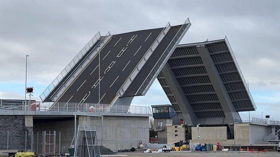
What type of bridge is it?

A hydraulic lifting system pulls the counterbalance downwards, while the other pushes the bridge span upwards
The double-leaf bascule bridge has an opening, known as a navigational envelope, for river traffic.
It opens in the middle to allow river traffic taller than 4.5m (15ft) through.
Marine traffic must have permission to pass from the bridge control team - even if the bridge does not need to be opened.
River users up to 50m (165ft) wide have been able to pass under the bridge since November.
If traffic is busy on the bridge, waiting pontoons are available on the western side of the river, for yachts and pleasure craft to moor up.
If one leaf has technical issues affecting a lift, the other leaf can open independently to allow some vessels through.

Herring Bridge should have opened in September 2023 but this was delayed until 1 February 2024
The bascule bridge was made in two halves by a specialist firm in Belgium, before being transported by sea and up the River Yare to be installed.
A floating crane lifted the the bridge span into place in March 2023.
Why was the project delayed?

A World War Two bomb exploded close to the third crossing construction site in February
The bridge was supposed to open in September 2023.
The first setback came in February when a 250kg (551lb) World War Two bomb was discovered by construction workers during dredging work.
The bomb detonated a few days later, when attempts were being made to defuse it. No-one was injured although there was some damage to a flood wall.
Work on the bridge resumed 10 days after the blast.

There is a bulge in the sea wall where the World War Two bomb exploded about 50m (165ft) from the bridge
The second delay followed the discovery by builders of a potential vole burrow, close to where the crossing was being built, in July.
It led to work having to be temporarily halted for a few weeks, as voles are protected by law under the Wildlife and Countryside Act 1981.
No voles were found following an exploration.
Where is the bridge?

Herring Bridge is near William Adams Way and connects Harfrey's Roundabout (A47) in the Southtown area of the town on the west side of the River Yare to the peninsula of Great Yarmouth on the east side, at South Denes Road (A1243).
The east side of Herring Bridge is built on a sand bank; the west side on what is effectively the mudflats of a river estuary.
Several buildings were demolished in the port area to allow the creation of new approach road structures.
Why is it called Herring Bridge?

Herring catch being landed at Yarmouth Wharf in 1932
The name was chosen by the public following a vote and has its roots in the town's fishing industry.
The town once boasted a large fishing fleet, with bumper catches of herring, external responsible for the area's wealth in the 1900s.
Nearly 6,000 votes were cast in the naming poll, with Herring Bridge receiving 2,710 votes.
Queen's Gate, Britannia Bridge, Yare Bridge and King's Bridge were the other choices.
Members of the public were invited to apply for tickets to take part in the opening ceremony.
Follow East of England news on Facebook, external, Instagram, external and X, external. Got a story? Email eastofenglandnews@bbc.co.uk, external or WhatsApp 0800 169 1830
Related topics
- Published24 January 2024