Land in Scotland owned by communities mapped
- Published

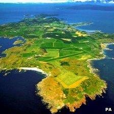
Gigha in the Inner Hebrides is among land in community ownership
New online maps have been produced to show changes in land ownership in the Highlands, Argyll, Moray, Orkney and Shetland from 1908 to the present day.
Published by Highlands and Islands Enterprise (HIE), one of the two maps shows where land has been taken over in community buy-outs.
The second provides details of more than 40 projects supported by HIE.
The agency said that as of March, more than 420,000 acres (169,967 ha) were in community ownership.
HIE added that this was more land than was owned in its region by the National Trust for Scotland, John Muir Trust and RSPB combined.
John Watt, who was involved in the maps project, said: "As a geographer it is particularly rewarding for me to see the interactive maps on HIE's website.
"They illustrate not only the wide geographical spread of exciting community-led development projects, but also offer details of the rich diversity of initiatives which are making Highlands and Islands communities stronger and more resilient."
Land in community ownership include the island of Gigha in the Inner Hebrides and estate lands in Knoydart and on the Western Isles.
Last year, a report said community land ownership was playing a successful role in encouraging people to live in remote and rural areas.
Scottish Agricultural College (SAC) researcher Dr Sarah Skerratt travelled across north and west Scotland in a mobile home to gather evidence.
Her journey by road and ferry took in community land trusts in Assynt, Lewis, Harris, South Uist, Skye, Knoydart, Rum, Mull and Gigha.
Populations on the community owned lands ranged from 23 people to 11,000.
- Published13 March 2012
- Published8 March 2012
- Published21 June 2011