Scapa Flow's historic wrecks mapped in sub-sea survey
- Published

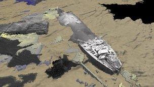
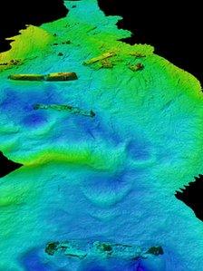
The remains of vessels are scattered in Burra Sound at Scapa Flow
A new sub-sea survey of Scapa Flow at Orkney has mapped 18 important historic wrecks.
Historic Scotland commissioned sonar surveys of the sea bed, which revealed new details, external on scuttled merchant ships from WWI and WWII.
It also showed a German submarine, and a trawler used to operate boom defences at the entrance to Scapa Flow.
The survey findings will help Historic Scotland to consider the case for a Historic Marine Protected Area.
This would improve protection for Scapa Flow's most important marine heritage sites under the Scottish Parliament's new marine legislation.
The research builds on earlier work from the ScapaMap project in 2001 and 2006, and Ministry of Defence studies of the wreck of battleship HMS Royal Oak.

The blockship Rotherfield was sunk in 1914
Scapa Flow was used in both world wars as a main harbour for the British Navy.
The Naval battleship Royal Oak was torpedoed in 1939, resulting in the deaths of 833 people.
Wessex Archaeology carried out the survey over two days in partnership with Netsurvey, contractors for the Ministry of Defence.
Philip Robertson, Historic Scotland's deputy head of Scheduling and Marine said: "The surveys are adding significantly to our understanding of what remains of the famous history of the wartime naval base of Scapa Flow, and the defence of the naval anchorage.
"We hope the results will be of interest to the thousands of recreational divers who visit Scapa Flow every year, and that those who don't dive will also enjoy this insight into the heritage that survives beneath the waves."
Paul Baggaley, Wessex Archaeology's head of geophysics, said: "We hope this survey of 18 sites has helped bring new information to light, and that it will provide a useful basis for efforts to monitor the condition of the wrecks in Scapa Flow, and conserve them for future generations to enjoy."
- Published30 July 2010