Wales Coast Path: Dangers from erosion and overgrown bushes
- Published

Strumble Head is a rocky headland off Pencaer that forms part of the path
Thousands of points along the Wales Coast Path could be lost to coastal erosion in the coming years, officers have said.
These are being monitored after a 50m (165ft) section at Strumble Head, Pembrokeshire, recently dropped away.
However, a bigger danger when trying to keep the 870-mile (1,400km) route, external open is overgrown foliage and grass.
More than half of Pembrokeshire Coast National Park's £150,000 budget goes on clearing this away.
"With bracken and gorse, if you miss it by a week or two, it will be completely overgrown," said trail officer Theresa Nolan.
"It's a major safety issue. If you don't know where you're putting your feet, it could be over a cliff."
The equivalent of 235 miles (379km) was cut last year and this can be a more pressing issue than rock falls caused by bad weather and erosion.
Because much of the route runs through private land, when rock falls happen, officers speak to owners about moving the path.
But Ms Nolan said it was getting "narrower and narrower" at some points.

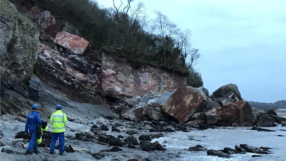
After major rock falls - such as this recent one at Oxwich Bay, Gower - the path is altered to make it safe
Other access issues include the firing range at Castlemartin, but after working with the Ministry of Defence, the stretch is now open in August and most weekends.
Then there are tidal crossings, such as at Sandy Haven, with a timber in the water helping people to cross at high tide.
Another issue that has emerged is stiles, which Ms Nolan said had been cut from 540 in 1993 to 29.
"Mobility scooters will get to all kinds of places but these were stopping them," she added.
Issues long-remedied by Pembrokeshire Coast National Park, which was established in 1952, are now faced by the rest of the Wales-wide route that only opened in 2012.

Linking up fields owned by different people in Gwynedd has proved challenging
With 25% of Wales' coast, about 180 miles, Gwynedd Council gets the largest share of government cash - £169,000.
Project officer Rhys Roberts said the council had created about 21 miles (35km) of new paths since 2010 and were hoping to add another six miles (10km) by 2022.
Linking up portions of land owned by different people, drawing up legal agreements and putting in fences to keep dogs away from livestock are some of the challenges.
Mr Roberts said another issue was how close the path can safely run near "dramatic coast".

A two-mile stretch on Anglesey, between Bryn Offa and Fedw Fawr, opened in October - is rugged and exposed to the elements
The path contributes £84.7m to the economy each year and supports 1,000 jobs, with Natural Resources Wales helping with the management.
"Pembrokeshire, Gower, Anglesey, the Llyn Peninsula are where more tourists go," said the organisation's Quentin Grimley.
"Traditionally, facilities in areas such as Newport, Monmouthshire and Flintshire are used more by locals."
Project officer Gruff Owen, said the "quite rough and industrialised" Flintshire coast had been "transformed, with interesting features such as viewpoints across the estuaries".
- Published7 January 2019
- Published14 December 2018