Super Typhoon Haiyan: Satellite images
- Published

Super Typhoon Haiyan has battered the Philippines with ferocious winds of up to 320 km/h (199mph). Although not the most powerful storm to have ever formed in recorded history, it could be the strongest at the time of landfall.

Satellite images show the extent of the storm as it approached the Philippines on 7 November. At times it stretched 600km (372 miles) across. If the same storm was placed over a map of Europe it would stretch from London to Berlin.
How Super Typhoon Haiyan would stretch if placed over Northern Europe

Super Typhoon Haiyan is the 25th tropical storm to enter Philippine territory this year and reports suggest there have been sustained winds of some 320 km/h (199mph) with gusts of up to 378 km/h (235mph).
The "worst" storm is hard to define as such events differ in extremes of wind speeds or gusts, pressure, damage or loss of human life. Some major storms also lose their ferocity as they cross the sea and make landfall.
Major storms in the Pacific region in recent years include the Super Typhoon Megi which hit the Philippines in October 2010 before picking up again and moving on to mainland China. Damage caused by winds reaching 268 km/h (167mph) left 200,000 Filipinos homeless.
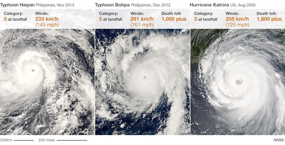
But there were surprisingly few fatalities compared with the 2012 Typhoon Bopha, whose 175mph winds wreaked havoc and caused more than 1,000 deaths - or the 1999 Orissa Cyclone in India which wiped out everything in its path, leaving more than 10,000 dead and millions homeless.
Hurricane Katrina, by comparison was Category 3, with winds of 205 km/h (125 mph) when it made landfall in August 2005 in the United States.

The relative strengths of Typhoon Haiyan (left), Typhoon Bopha (centre) and Hurricane Katrina (right)
Katrina's trail of destruction through the Bahamas, Florida, Louisiana, Mississippi, and Alabama left around 1,800 people dead and caused an estimated $108bn in damage.