Ethiopia apologises for map that erases Somalia
- Published

The Ethiopian foreign ministry said it was unsure how the map had "crept in on the website"
Ethiopia's foreign ministry has apologised after a map of Africa on its website incorporated neighbouring Somalia within its own borders.
"We sincerely regret any confusion and misunderstanding this incident might have caused," the statement said.
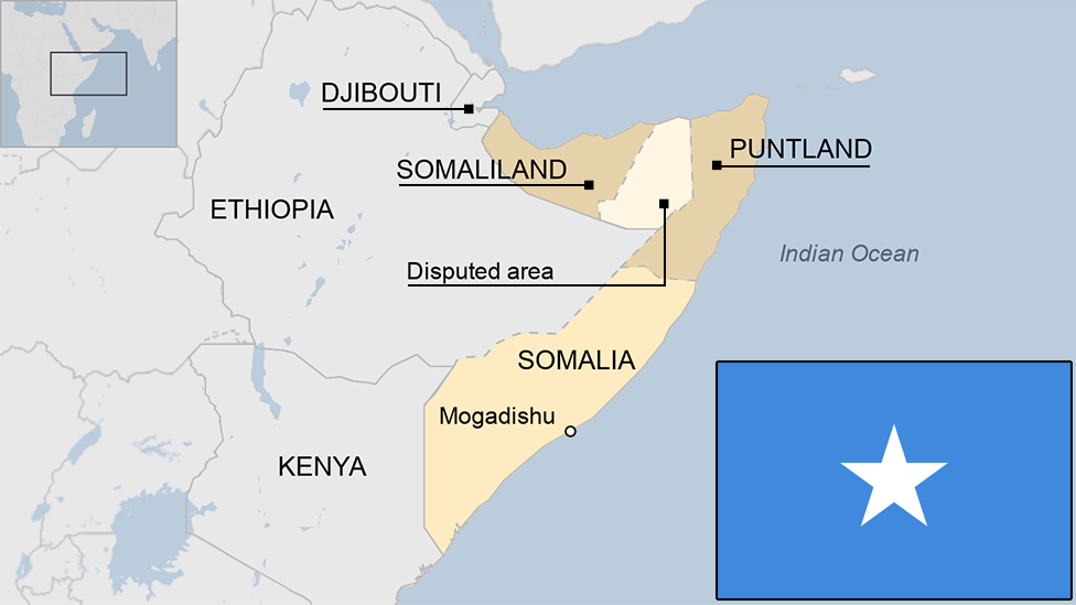
Somalia had been completely erased from the map, but the self-declared territory of Somaliland - which is not internationally recognised - was shown.
The neighbours have long been rivals, fighting borders wars in the past.
But relations between the two countries have improved since Ethiopia's Prime Minister Abiy Ahmed came to power last year as he has sought to defuse tensions in the region.

Timeline: Ethiopia and Somalia
1964 and 1977: Two wars fought over Ethiopia's Somali-inhabited Ogaden region
1988: Peace accord signed, three years later Somalia descends into civil war
1996: Ethiopian forces enter Somalia to defeat Islamist fighters in the town of Luuq
2006: Ethiopian troops intervene in Somalia and remove Islamists from power
2009: Ethiopian soldiers officially leave Somalia, but remain in the country to this day as part of the African Union intervention force fighting al-Shabab Islamist militants
June 2018: Ethiopia's new PM Abiy Ahmed visits Somalia to strengthen ties
Oct 2018: Mr Abiy's government signs a peace deal with rebels fighting for Ogaden's secession
Read more: The leader promising to heal a nation
The map has caused an uproar on social media, with Somalis saying it reveals a wider plan by Ethiopia to annex their country.
Others hit back, with their own version of a map of Africa, incorporating Ethiopia into Somalia.
Allow X content?
This article contains content provided by X. We ask for your permission before anything is loaded, as they may be using cookies and other technologies. You may want to read X’s cookie policy, external and privacy policy, external before accepting. To view this content choose ‘accept and continue’.

Some have noticed other problems with the map published on the Ethiopian website, for example, it showed that the Republic of Congo and the Democratic Republic of Congo had become one country and it did not show South Sudan, which split from Sudan in 2011.
There has been no official comment from the Somali government. Former Foreign Minister Yusuf Garaad welcomed the removal of the map, but queried how and why it was drawn in the first place, external.
The Ethiopian foreign ministry's statement said it was unsure how the "unacceptable" map had "crept in on the website", external, which is currently offline, but said its technical team was working to ensure its security.

- Published3 January 2019

- Published2 January 2024
- Published18 September 2017
- Published18 May 2016