Mapping Typhoon Haiyan
- Published
Millions of people have been affected by the typhoon which swept through the Philippines with winds gusting up to 270km/h. Parts of the low-lying islands were completely flattened and many hundreds of thousands of people are now homeless.
Path of the typhoon
The map below shows the path of the storm through the Philippines. The worst-affected islands include Leyte and Cebu.

Relief Web has produced estimates of the numbers of people affected in each province. It says Tacloban City in Leyte province has been devastated, with most houses destroyed. In total, 670,000 people are said to have been displaced - about 55% of them are living in evacuation centres.
But with roads blocked and poor communications, a complete picture of how many people have been affected may not emerge for some time.
Height of the the storm surge
The strong winds whipped up by Typhoon Haiyan also contributed to a storm surge, which sent a wall of water crashing through some low-lying areas. The storm surge reached its height at the city of Tacloban.

Although official calculations by the Global Disaster Alert and Coordination System (GDACS) put the height of the storm surge in Tacloban at 2.3m, local conditions will have meant the actual level was far higher.
The city is located at the head of a bay which faced directly towards the oncoming typhoon and the arrival of the storm surge coincided with a high tide forcing the water levels up to about 5m.
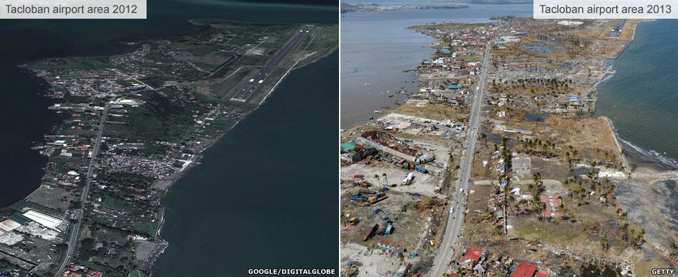
Tacloban devastation
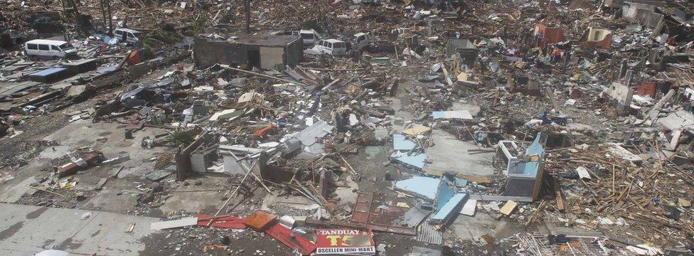
The typhoon and storm surge has destroyed much of Tacloban, flattening buildings and leaving many of the 220,000 population homeless. Piles of debris are now hampering relief efforts and people are desperate for food and shelter.
-
× -
Tacloban city devastated by storm surge
×
Aid efforts in the Philippines have been hampered by bad weather. Millions of people have been affected and relief workers are struggling to get supplies into the worst-hit areas.
The exact number of dead is still unknown – but it is believed more than 10,000 residents died in the city of Tacloban alone.
Jon Donnison reports from the city where hardly a single building has been left standing.
-
City flattened
×
Much of Tacloban was devastated by the typhoon and resulting storm surge. Roads in and out of the city have been blocked by people trying to get in to find relatives and friends and people desperate to get out. Officials say the death toll may rise even further than the current 10,000 estimate as the full scale of the devastation becomes clear. Most of those who died are thought to have drowned or been crushed by collapsing buildings.
-
Airport damaged
×
Hundreds of people have gathered at Tacloban airport � some are desperate for food and water, while others are trying to get a flight out. The airport partially reopened on Monday 11 November, three days after the typhoon, but only for flights carrying relief supplies and equipment. The airport has also become a makeshift morgue for the growing number of bodies.
-
Evacuation centre
×
The city’s sports stadium withstood the force of the storm and thousands of people have now taken up temporary residence there. There have been reports of people attacking trucks loaded with food, tents and water, as supplies of food and medicine in the city run low. Severed roads and communications have hampered relief efforts.
The city lies on the easterly island of Leyte and caught the full force of the typhoon with winds approaching 310km/h (195mph).
The spit of land on which Tacloban airport is located and the downtown areas are the parts of the city that have been worst-affected.


Once the relief effort is completed, rebuilding Tacloban could take many years.

