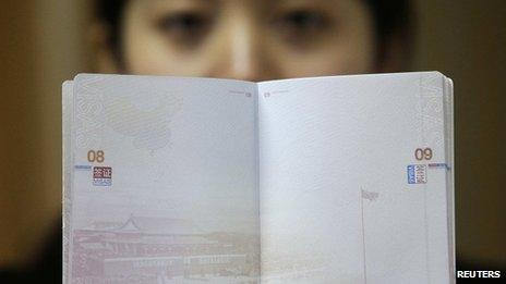
India and China row over new map in passport
- Published

Several of China's neighbours have also protested against the new map
A fresh row has broken out between India and China over territorial claims in the north-eastern Indian state of Arunachal Pradesh and the Aksai Chin area in eastern Kashmir.
In new passports, China's maps show the two areas as Chinese territory.
The Indian embassy in Beijing is said to have retaliated by stamping Chinese visas with a map of their own which shows the territories in India.
Several of China's neighbours have also protested against the new map.
Vietnam, the Philippines, and Taiwan have all objected because it shows disputed islands in the South China Sea and Taiwan to be a part of China.
They have described the new design as a violation of their sovereignty.
Chinese official maps have long shown Taiwan and the South China Sea to be part of its own territory, but the inclusion of such claims on the passport has caused considerable anger.
The potentially oil-rich Paracel Islands, claimed by Vietnam since their troops were forced to leave by China in the 1970s and also claimed by Taiwan, make an appearance on the map, as do the Spratly Islands, part of which are claimed by the Philippines.
The disputed Senkaku or Diaoyu islands, at the centre of recent tension between China and Japan are not included in the new document.
Relations between India and China have been uneasy - the two countries dispute several Himalayan border areas and fought a brief war in 1962.
Delhi is yet to officially take up the row over the map with Beijing.
- Published6 September 2012
- Published20 April 2012
- Published13 December 2011
- Published4 September 2012
- Published27 August 2012