In maps: Houston and Texas flooding
- Published
Houston is battling to recover from devastating flooding caused by Hurricane Harvey, a category four storm which dumped a record breaking amount of rain on the city.
At least 33 people are known to have died across Texas, while thousands of people have fled their homes to emergency shelters.
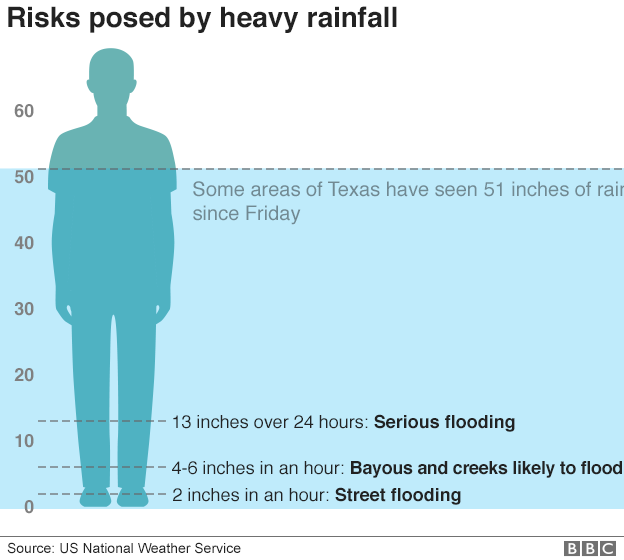
The rainfall in Texas set a new record for the continental US, the National Weather Service has said. A rain gauge in Cedar Bayou recorded 51.88 inches (132 cm) of rain from Friday 25 August to Wednesday 30 August.
Before and after
Imagery from the TerraSAR-X radar satellite shows the extent of flooding up to Monday 28 August.
The artificially blue-coloured areas show water detected before and after the storm.

Relief effort in Houston
Police have rescued some 3,500 people from floodwater in the Houston area, and more than 32,000 people are being housed in emergency shelters across the state.
In Houston, the George R Brown Convention Center, which has a 5,000 capacity, has sheltered up to 10,000 people forced from their homes.
Victims are now being sent to a new relief hub at the larger NRG Center.
On Tuesday, televangelist Joel Osteen opened his 16,000 capacity Lakewood Church, after criticism that it was not initially accepting people seeking shelter.
Eyewitness: What is it like in Houston?
Houston's Mayor Sylvester Turner has requested assistance from the Federal Emergency Management Agency (Fema) to shelter an additional 10,000 people.
Up to 500,000 people in Texas will ultimately require some form of assistance, federal officials estimate.
A curfew has been established in Houston from midnight-05:00 local time (05:00-10:00 GMT).
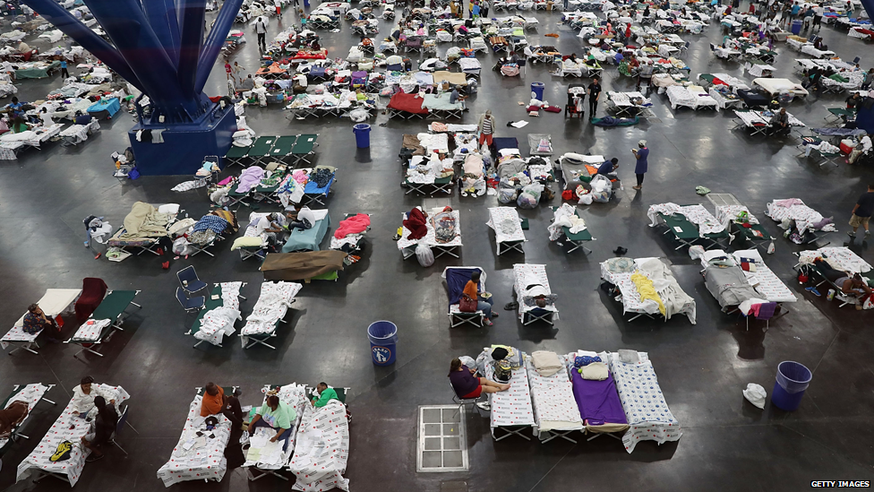
Thousands of people are sheltering in the George R Brown Convention Center.
Damage in Houston
The cost of reconstruction in Houston could be as high as $200bn, the Lieutenant Governor of Texas Dan Patrick has said.
At least 50,000 homes are flooded in the Houston area, Texas officials say, with the figure expected to rise.
At its peak, a third of Harris County, part of the Houston metropolitan area and home to 4.6 million people, was reportedly underwater - an area 15 times the size of Manhattan.
The Addicks and Barker reservoirs to the west of the city reached overflow levels, with engineers performing controlled releases of water into the Buffalo Bayou, which flows through central Houston.
More than 4,000 houses near the two reservoirs were flooded as waters backed up, the Houston Chronicle reported., external
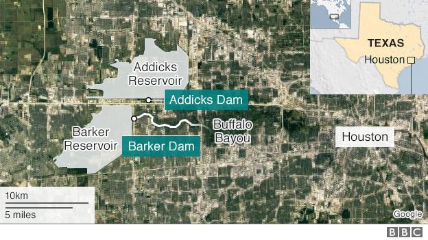
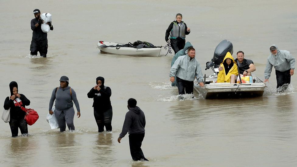
More than 3,000 people have been rescued in Houston alone.
Bridges and roads have been damaged, but both of Houston's airports partially re-opened on Wednesday after several days closure.
The oil and chemical industry, which has extensive facilities in Texas, has also suffered.
America's largest oil refinery , run by Motiva Enterprises in Port Arthur, could be closed for up to two weeks. The refinery produces more than 600,000 barrels per day.
A key network of pipelines supplying fuel to major US cities has been shut down due to the disruption.
Explosions have been reported at the Arkema chemical plant in Crosby to the north east of Houston, amid warnings that volatile compounds could not be kept safe due to a failure of refrigeration systems.
Shell boss takes stock of storm disruption
Further south, buildings on the coast were destroyed and damaged by high winds as Hurricane Harvey made its initial landfall, with gusts reaching 130mph.
Record rainfall
Hurricane Harvey broke the previous continental US record for rainfall delivered by a single tropical depression, with almost 52 inches falling in Cedar Bayou by 30 August.
The previous record was 48 inches, which fell during Tropical Storm Amelia in 1978, also in Texas.
Flooded rivers
On 30 August, US Geological Survey (USGS) data showed rivers at 50 locations across a huge swathe of south and east Texas at so-called 'flood stage'.
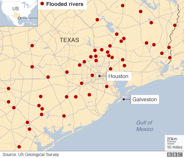
This is defined by the US National Weather Service, external as the level at which water is inundating areas normally dry areas, causing disruption or a threat to life and/or property.
Some are in densely populated areas, and others are in or near remote, rural and isolated communities.
Path of the storm
Hurricane Harvey initially made landfall near Corpus Christi late on Friday 25 August, but then doubled back on itself and headed back out into the Gulf of Mexico.
By 18:00 GMT on Friday, sustained wind speeds had dropped to 70mph, downgrading it to a tropical storm. At this point, the storm was travelling very slowly - at about 2mph - making the effect of the rainfall inland worse.
Forecast track: Friday 25 August
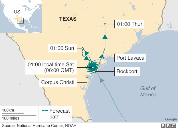
Forecast track: Wednesday 30 August
The storm made landfall again in the neighbouring state of Louisiana, which saw devastating flooding from Hurricane Katrina in 2005.
Heavy rainfall is expected from Louisiana to Kentucky over the next three days, and flood warnings remain in effect for south-east Texas and parts of south-west Louisiana.
