Google Earth images used to reject planning appeal

One of the three Google Earth images used to throw out the appeal
- Published
A planning appeal has been thrown out after Google Earth satellite images were used to disprove claims by the company making the application.
RCR Limited said the former gasworks site they had taken over in Innerleithen about three years ago had been used as storage for more than 30 years.
Earlier this year, their plan to turn the gasholder site into a storage yard was rejected by the Scottish Borders Council, a decision which they appealed for the Scottish government to overturn.
That appeal has now been rejected after the Google Earth images from 2007, 2014 and 2022 showed no sign of storage on the land.
- Image source, Google Earth
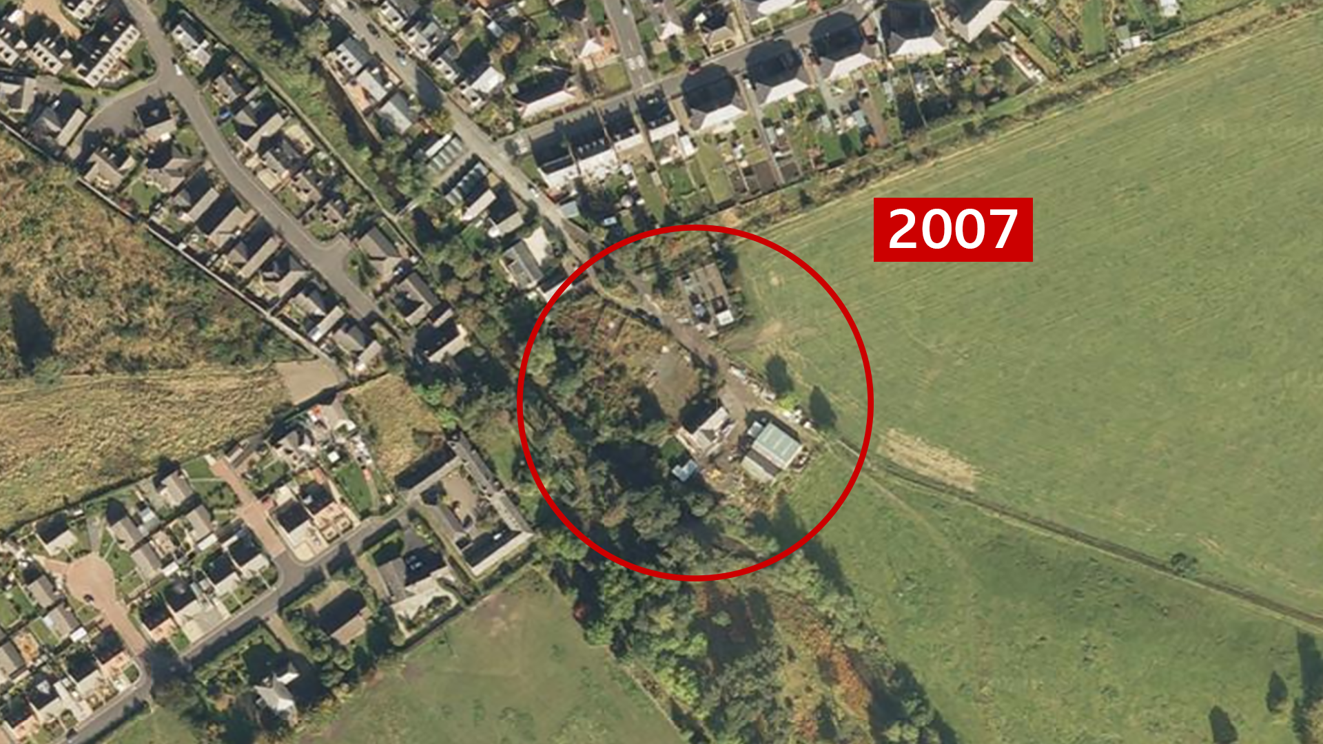
Image caption, The Google Earth images date back 15 years ago


1 of 4
RCR Limited bought the site from gas distribution company SGN on 2 November 2022.
Their plans to turn the site into an "excellent storage space" was dismissed by the council on the grounds of a flood risk.
The company appealed against this decision, claiming the site had been used as a storage area by the previous occupiers.
RCR said SGN and other suppliers had used the Princes Street space to store waste, signs, barriers and other materials.
They said that turning the site into a storage yard was just a continuation of what had gone on before.
However, in documents related to application, SGN said: "While the site may have been used by the local depot as a storage area, officially, the site was classified as vacant with access for maintenance purposes only."
SGN said that it would be an overstatement to say the site was used for storage.
'Heavily overgrown'
In his appeal decision notice, the planning reporter appointed by Scottish ministers, Malcolm Mahony, said aerial imagery from Google Earth in July 2022, showed the site as overgrown, with blocks at the entrance.
Further images from 2007, 2014 and 2022 do not show reasonable evidence of storage use, he said.
Storage containers only appear in the Google Earth search in the year 2025.
However, three years before that, the satellite images show trees and greenery around the site area.
Locals from the nearby small town in Tweeddale had also disagreed with RCR's storage claims.
In a written letter to the Scottish government planning appeal, Aileen Logan who has lived near the site for about 45 years, said: "At that time there was a working gasometer on the site.
"This was subsequently removed and the site was locked up and abandoned becoming heavily overgrown."
"At no time did the Gas Board use this site for storage."
She said the street leading to the site is extremely narrow and would be unsuitable for works traffic.
Ross McGinn, who has lived near the site for more than 30 years and is part of Innerleithen Community Trust, said that RCR's claims were "totally false".
After reviewing the evidence, Mr Mahony said that on the balance of probability there was insufficient evidence of continuous use throughout the 10-year period required and the appeal failed.
Related topics
- Published2 July

- Published23 June