Amber warning for wind ahead of Storm Éowyn

The Met Office has forecast gusts of up to 90mph in exposed coastal areas
- Published
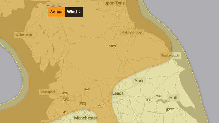
An amber warning for wind has been issued across large parts of Yorkshire, as dangerous Storm Éowyn heads towards the UK.
The Met Office has warned people to expect gusts up to 70mph inland and up to 90mph along more exposed coasts and hills, saying flying debris could cause a danger to life or injury.
The alert, which comes into force across parts of North, West and South Yorkshire from 06:00 on Friday, said the storm was expected to bring widespread disruption to road, rail and air travel air travel.
It said power cuts were also likely and there was the possibility of damage to buildings and homes.

The amber weather warning covers parts of North, West and South Yorkshire
Analysis - Paul Hudson, BBC Yorkshire Weather
Storm Éowyn is on its way.
For us, it will be the most powerful storm so far of autumn and winter and, potentially, the most disruptive.
So, hardly surprising we have got an amber warning in place.
The jet stream is really driving and developing this system.
The main thing, though, is the timing of this feature, because these highest gusts will be late morning to late afternoon.
That's why we think there could well be some disruption.
National Highways have issued an amber severe weather alert for gales, external from 07:00 on Friday, advising road users to check ahead and plan for disruption to their journeys.
Dee Murray, operations manager at National Highways, said: "Tonight we're into a yellow weather warning.
"We've got rain and we've got high winds.
"Tomorrow morning we go into an amber weather warning, which means the wind levels increase, so people need to be aware on the road.
"If they're in smaller vehicles they could be forced to change direction by the wind [and] it's not always obvious when that's going to happen."
A number of rail companies have advised passengers to either avoid travelling entirely or to only make the journey if necessary.
TransPennine Express (TPE), external has warned people not to travel on routes between York, Newcastle and Edinburgh and advised people to avoid travelling "unless absolutely essential" between Manchester, Huddersfield, Leeds and York.
Andrew McClements, customer experience and transformation director for TPE, said: "The arrival of the storm is expected to create some quite significant disruption across the whole rail network.
"Working with other parts of the railway, including Network Rail, we've had to amend quite a lot of our services on Friday.
"Customers, regrettably, should expect to see some significant service amendments and some widespread disruption."
Northern, external have also asked people not to travel on some routes, including between Bradford, York and Blackpool, Huddersfield to Sheffield and trains from Leeds to Manchester via Hebden Bridge.
In North Yorkshire both Castle Howard and Fountains Abbey said they would be closed on Friday due to the high winds.
Storm Éowyn is the fifth named storm of the season. It has been caused by powerful jet stream winds pushing low pressure towards the UK and Ireland over the Atlantic Ocean - after a recent cold spell over North America.
Listen to highlights from North Yorkshire on BBC Sounds, catch up with the latest episode of Look North or tell us a story you think we should be covering here, external.
- Published23 January

- Published22 hours ago
