Hurricane-force winds leave 214,000 without power in NI

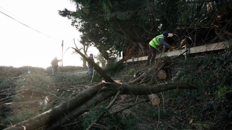
A tree fell on a street in south Belfast
- Published
Storm Éowyn brought winds of more than 90mph to Northern Ireland, leaving thousands of homes and businesses without power.
About 214,000 properties were without electricity as of 21:30 GMT on Friday.
At its peak 30% of all premises in Northern Ireland had their power disconnected.
Northern Ireland has seen the highest gust in 27 years.
The rare red weather warning, which began on Friday morning, has now ended.
On Friday evening the executive met and agreed to write to the prime minister to ask for assistance in dealing with the impacts of the storm.
NIE Networks have advised the public to stay well clear of any damaged electricity equipment as Storm Éowyn continues to cause significant damage to the electricity network.
In the Republic of Ireland, a man died after a tree fell on the car he was driving in Raphoe, County Donegal, in the early hours of Friday morning.
More than 625,000 properties are still without power and more than 138,000 without water in the Republic of Ireland as Storm Éowyn causes chaos across the island.
Along with wind warnings until midnight, a snow and ice warning has also been issued across Northern Ireland from 19:00 on Friday – 10:00 on Saturday.

Top winds gusts as of 13:00 GMT
Follow our live page for the latest developments on Storm Éowyn.
On Friday evening the executive met and agreed to write to the prime minister to ask for assistance in dealing with the impacts of the storm.
First Minister Michelle O'Neill also raised the issue of support with the Tánaiste (Irish deputy prime minister) Simon Harris.
The strongest gust of wind recorded in Northern Ireland until 11:00 GMT on Friday was 92.2mph (148km/h) at Killowen in County Down.
That is the strongest gust since 93mph (150km/h) was recorded at Ballykelly in County Londonderry on Boxing Day in 1998.
Gusts of 83mph (133.5km/h) have also been recorded in Ballypatrick Forest in County Antrim, and 82.7mph (133km/h) in Magilligan, County Londonderry.
Provisional new records for wind speed have been recorded in the Republic Ireland, with hurricane-force sustained winds of 85 mph (137 km/h) at Mace Head, County Galway.
You can read more about the weather situation in the Republic of Ireland here.
Closures

Killowen, County Down recorded the strongest gusts
Before the storm hit the Met Office said there was a danger to life and political leaders urged people to stay at home.
A number of businesses, including supermarkets Lidl, Tesco and Sainsbury's, closed ahead of the severe winds.

Waves hit the coast at Carnlough in County Antrim
Transport and travel
Public transport service provider Translink cancelled all bus and train services during the red alert.
A limited Metro and Glider service resumed in Belfast at 5pm on Friday, with buses from Belfast to Dublin, including Dublin Airport, and Belfast's International and City Airports also beginning at the same time.
However, Ulsterbus and Foyle services will not return until Saturday, with Translink warning these routes may still be subject to disruption and diversions due to road closures.
No rail services will operate for the remainder of Friday, and there is potential impact to some early Saturday morning services as well.
Translink's Director of Service Operations, Ian Campbell, said: "We have already identified there are several railway lines blocked with fallen trees and debris that will need removed."
Widespread damage

Another roof ripped off in the storm
As the strong winds swept across the island of Ireland there has been damage to buildings and trees have fallen down, blocking roads and damaging homes
The roof of Drumrane Primary School in Dungiven, County Londonderry, has been badly damaged.

Mary Greer, pictured with her son John, has had yet more damage to her home
In Whiteabbey, Mary Greer's house was damaged by fallen branches.
It is the fourth time in just three years storms have caused her home to be damaged.
"I just heard a big bang and my heart sank," she told BBC News NI.
"We have had a tree through our conservatory, we've had our car damaged and our roof damaged twice."
The house next to Mrs Greer's was also extensively damaged.
"The couple who were in there were so lucky they weren't killed," she added.

This wall came down in the Northland Crescent area of Londonderry
An area of Northland Crescent in Derry was cordoned off on Friday morning after a wall collapsed.
Extensive damage was caused to one vehicle with the boot and side of the vehicle badly damaged.

It is not the first time damage has been caused to the Aurora's roof
The roof of Bangor Aurora leisure centre has also been damaged and has been damaged in previous storms.

Damage to a home in Coalisland, in County Tyrone
In Coalisland, in County Tyrone, many trees have blocked roads and the roof of one bungalow has been torn off in the wind.

Multiple trees have been taken down by Storm Éowyn including this one on the North Road in East Belfast

Cars damaged by fallen trees in Dundonald

A tree fell onto a house in Brookeborough, County Fermanagh
Gusts of 85mph were recorded in County Fermanagh at the height of the storm.
There are hundreds of trees down across the county, with many taking power lines and phone lines down with them.
As well as electricity outages, connectivity is a real problem in the county with no phone signal or broadband in many places.

A telegraph pole was pulled up by the strong winds and landed on Blaris Road

Malachy Quinn in front of the tree blocking the lane to his house
Malachy Quinn is an SDLP councillor for Mid Ulster.
Fallen trees are blocking both entrances and exits on the lane up to his house near the Washingbay area of County Tyrone.
He said: "It looks as though the tree has come down on the telephone lines in one of the lanes here and so it's a very volatile and very dangerous situation at the minute.
"Local people have been contacting me since 6am this morning about trees coming down left, right and centre."
Calls to PSNI have doubled

PSNI Assistant Chief Constable Davy Beck said we are yet to "fully appreciate the impacts of this storm"
PSNI Assistant Chief Constable Davy Beck said police have received about 2,000 calls throughout the day, which is 50% more than they would normally expect on a normal Friday.
This is due to impassable roads, debris, and fallen power lines.
"We're only now starting to see the number of calls start to rise in respect of impacts, concerns for safety, and indeed, more and more reports in respect of roads blocked and on issues as a consequence of that," he said.
"So I think it's going to be a number of days before we can fully understand the full impacts of this storm."
He urged the public to continue to stay at home and only travel if absolutely necessary as the high-impact amber warning continues.

Deputy First Minister Emma Little-Pengelly, Ass Ch Cons Davy Beck and First Minister Michelle O'Neill held a press conference on Thursday at Stormont
On Thursday, First Minister Michelle O'Neill advised people to work from home and avoid unnecessary travel.
She added that she wanted to emphasise that a red warning was very serious and was only used when there was a genuine threat to life.
Deputy First Minister Emma Little-Pengelly added that people should stay inside where possible.
Education Minister Paul Givan said he understood the closure of schools would affect pupils and businesses but the decision had been taken "to avoid any potential risk to life for children and young people as well as staff".
The UK government issued the "largest real life use to date" of its Emergency Alert system, notifying about 4.5 million people of severe weather in Northern Ireland and parts of Scotland.

An alert was sent on Thursday to phones warning of high winds
Healthcare
Some hospitals across Northern Ireland are running on generators, but they can run for about 200 hours so there are no immediate concerns.
As expected, Storm Éowyn has brought disruption to ambulance services in Northern Ireland.
The service's strategic commander, Mark Cochrane, told Evening Extra that the service has been acting at a "critical incident level" and is now considering how to return to normal.
Challenges have included staff getting to work due to debris and property damage, as well as difficult road conditions causing issues in getting to patients.

A departures board at Belfast City Airport showed cancelled flights on Thursday evening
Have flights been cancelled?
A number of flights from Belfast City Airport were cancelled but some departures and arrivals are scheduled for later than expected.
Belfast International Airport and City of Derry Airport warned people to expect delays and cancellations.
Dublin Airport said there could be "some disruption" to Friday's flight schedule and that passengers should contact their airline directly for updates.
P&O has announced ferry cancellations between Larne and Cairnryan from 04:00 to noon and Stena Line services between Ireland and Great Britain are also severely disrupted.
Ireland West Airport in County Mayo was closed until 13:00.
Another storm coming on Sunday
A wind warning has been issued across Northern Ireland on Sunday ahead of Storm Herminia.
This storm has been named by the Spanish Met Office, with more impacts expected there.
The system is not forecast to be as severe for Northern Ireland as Storm Éowyn.
The Met Office is warning of gusts between 50 to 60 mph, and higher over some exposed coastal areas.
The yellow warning comes into force at 08:00 on Sunday and lasts until 15:00.
Those gusts could hamper clean up operations and repairs following Storm Éowyn.
Storm Éowyn is the fifth named storm of the season. It has been caused by powerful jet stream winds pushing low pressure towards the UK and Ireland over the Atlantic Ocean after a recent cold spell over North America.
Red is the most serious weather warning the Met Office can issue, meaning dangerous weather is expected and people are urged to take action to keep themselves and others safe.
It was the first time a red weather warning was issued for Northern Ireland since an impact-based system was introduced in 2011.
Emergency contacts
To report faults or emergencies you should contact:
Northern Ireland Housing Executive: 03448 920 901
Openreach: 08000 23 20 23
Gas networks: 0800 002001
NI Water: 03457 44 00 88 or visit niwater.com, external
Flooding Incident Line: 0300 2000 100
NIE Networks: 03457 643 643 or visit nienetworks.co.uk, external
Get in touch
Are you without power due to Storm Éowyn? Are you impacted in other ways? Get in touch.
Related topics
- Attribution
- Published1 August

- Published20 November
- Published24 January