Media caption,

Snow and ice warnings issued for parts of UK

  1. Dozens of postcodes already reach criteria for cold weather paymentspublished at 13:51 Greenwich Mean Time 3 January

    Cold weather payments have already been triggered in dozens of postcode areas in Cumbria, Northumberland and parts of England in the Scottish Borders.

    As the cold snap continues, the Department of Work and Pensions is urging low-income households to check their eligibility for the payment:

    In Scotland, those on low incomes and benefits may receive a separate winter heating payment, which does not depend on how low the temperature falls.

    As a reminder, the cold weather payment is a government benefit top-up to help with fuel bills, external. Read more about it here.
  2. What weather warnings are in place?published at 13:40 Greenwich Mean Time 3 January

    If you're only just joining us, here's a quick breakdown of all weather warnings currently in place and the ones expected to be over the weekend:

    • A yellow weather warning for ice is in place in parts of Scotland, Northern Ireland and west Wales until 10:00 GMT on Saturday
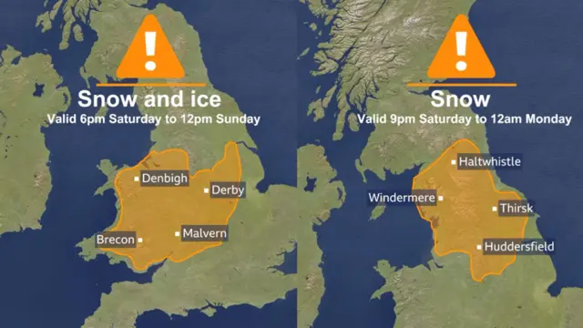
    • One amber warning for snow and ice will be in place from 18:00 GMT tomorrow until 12:00 GMT on Sunday for the East Midlands, London and south-east England, north-west England, Wales and south-west England
    • Another amber warning for snow will be in place from 21:00 GMT on Saturday until 23:59 GMT on Sunday for north-east England, the East and West Midlands, north-west England and Yorkshire and Humber
    • A separate yellow warning for ice and snow will be in place from 12:00 GMT tomorrow for almost all of Wales and almost all of England, excluding the south-west. The warning will lapse Sunday night
    • The Environment Agency has also issued four flood warnings and 34 flood alerts
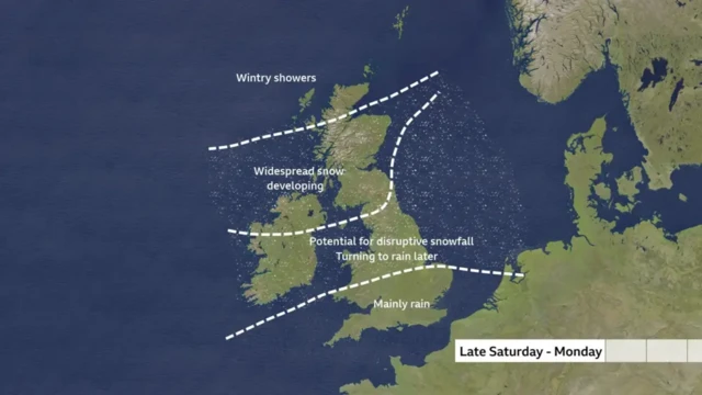
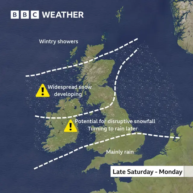
    Weather map of the UK with the nation split in four sections horizontally by white dotted lines. The far north section of Scotland can expect wintry showers, rest of Scotland, northern England and NI are marked for widespread snow developing, central England and North Wales face potential for disruptive snowfall turning to rain later, southern England marked for mainly rain
  3. BBC Weather forecast: Freezing temperatures and snowpublished at 13:31 Greenwich Mean Time 3 January

    The latest BBC Weather forecast predicts disruptive snow for some through the weekend.

    Overnight tonight, the winds will lighten with freezing fog patches as much of the country plunges into sub-zero temperatures.

    As reported earlier, fresh amber warnings for snow and ice have been issued for large areas of England and Wales this weekend. You can check your local weather forecast here.

    Media caption,

    Snow on the way

  4. Where can you find emergency shelter?published at 13:15 Greenwich Mean Time 3 January

    With temperatures set to drop below freezing, councils inthe west of England are taking emergency action to help rough sleepers.

    Several, including councils in Gloucestershire, Bristol, Swindon, Kent, Surrey, Sussexand Londonhave activated their Severe Weather Emergency Protocols (SWEP) which provide free emergency overnight accommodation for anyone without shelter.

    Each local council has its own criteria for deploying SWEP, but it generally comes into force when temperatures are set to fall below 0C or an ice and snow weather warning is issued.

    Anyone concerned for a person sleeping rough can notify their local outreach service via StreetLink, external.

    A team will then be sent to check on the person's welfare and offer them SWEP shelter.

  5. 'We are under extreme pressure', warns chief of hospital grouppublished at 13:02 Greenwich Mean Time 3 January

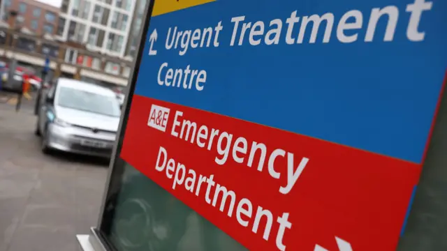
    A sign displaying an arrow to an 'Urgent Treatment Centre' and another arrow to the 'Emergency Department'Image source, Getty Images

    We've just heard from a chief at a London and Surrey hospital group warning that services are under "extreme pressure" as medical staff brace for the impact of this weekend's cold snap.

    Emergency departments at St George's, Epsom and St Helier's are expecting demand to soar after the Met Office predicted snow and sub-zero temperatures.

    “Our hospitals are very stretched and we are under extreme pressure," says Professor Arlene Wellman MBE, group chief nurse for the hospital group. “We expect to see higher demand during cold spells and in the days that follow, and are doing everything we can to handle this."

    Dr Richard Jennings, St George's, Epsom and St Helier's group chief medical officer, adds: “It’s a common misconception that you will be seen more quickly if you visit an emergency department when it’s not an emergency – but in fact, you will wait longer...If you haven’t done so already, get your flu, RSV and Covid jabs if you’re eligible.”

  6. Baby dies in A1 car crash, with police investigating link to icy conditionspublished at 12:49 Greenwich Mean Time 3 January
    Breaking

    A seven-month-old baby has died after a crash on the A1, as officers investigate whether the incident was linked to icy conditions.

    Lincolnshire Police were called to the southbound carriageway at 22:50 GMT on Thursday, near the A52 junction at Grantham after a yellow Honda Jazz left the road and crashed into a tree.

    The baby boy suffered serious injuries and was taken to hospital but died just after 05:00 on Friday. A woman travelling in the car also suffered serious injuries.

    The southbound carriageway remains closed while investigations take place.

  7. Up to 30cm of snow possible for higher groundspublished at 12:45 Greenwich Mean Time 3 January

    Simon King
    BBC weather presenter and meteorologist

    Whilst there is some uncertainty in details, 3-7 cm of snow is likely, with locally 15-30 cm for the higher ground of Wales and southern Pennines.

    Freezing rain – where rain falls onto surfaces below zero degrees and instantly freezes – will bring the extra hazard of icy surfaces Milder air will then lead to a rapid thaw of snow and ice in south Wales and the Midlands during Sunday.

    There is an additional amber warning for northern England from 21:00 Saturday to 23:59 on Sunday as the risk of significant snow transfers north.

    Widely there’ll be 3-7 cm of snow with 15-40cm over high ground before snow begins to ease and clear by the end of Sunday.

    For some lower-lying areas, such as the Vale of York, snow may mix with rain at times making estimations of snow depths here more difficult.

    There’s a risk of travel disruption, rural communities being cut off and potentially power cuts.

  8. A frosty weekend aheadpublished at 12:41 Greenwich Mean Time 3 January

    Simon King
    BBC weather presenter and meteorologist

    With temperatures falling quickly again on Friday night, there is a risk of icy surfaces, especially in North Wales, north-west England, most of Scotland and parts of Northern Ireland.

    There’s a Met Office yellow warning in these areas from 16:00 GMT Friday to 10:00 Saturday.

    Saturday will be largely dry but cold with maximum temperatures barely above freezing for many. Later in the day though rain will spread in across southern England and Wales, spreading north-east.

    This rain will temporarily turn to snow in southern areas and maybe give a small covering in places, especially over high ground.

    But ultimately, with milder air coming in, it’ll turn quickly back to rain.

    There’ll be a more sustained period of snow and freezing rain for Wales and the Midlands where an higher level amber warning has been issued by the Met Office from 18:00 Saturday to 12:00 GMT Sunday.

  9. Amber warnings to remain in place throughout weekendpublished at 12:30 Greenwich Mean Time 3 January

    Two side-by-side maps of the UK outlining the areas covered by an Amber Weather warning over the weekend. To the left, an area covering most of Wales and parts of the Midlands is highlighted in orange. To the right, northwestern England, parts of northeast England and Yorkshire and the Humber is marked in orange

    As we mentioned earlier, yellow weather warnings are in place in parts of Scotland, Northern Ireland and west Wales with forecasts of ice and even snow in northern Scotland on Friday.

    The Met Office has also issued two amber warnings for snow and ice from 18:00 GMT tomorrow for the East Midlands, London and south-east England, north-west England, Wales and south-west England.

    Another amber warning for snow will be in place from 21:00 GMT on Saturday for north-east England, the East and West Midlands, north-west England and Yorkshire and Humber.

    And a separate a yellow snow and ice warning covers almost all of Wales and almost all of England on Saturday, excluding the south-west.

    The snow and ice warning continues into Sunday, with an extra yellow snow warning covering Scotland.

  10. Snow and ice expected as mercury dips below -8.1Cpublished at 12:14 Greenwich Mean Time 3 January

    The snow and ice expected for large areas of England and Wales this weekend follow temperatures dipping to -8.1C on Friday morning.

    Benson in Oxfordshire recorded that temperature - the UK's lowest - after southern England experienced its coldest night of the winter.

    Elsewhere in England, temperatures dropped to -7.5C in Shap, Cumbria, and -6.7C at Bournemouth Airport.

    In Scotland, the lowest temperature was -6.4C in Eskdalemuir, Dumfries and Galloway, while in Wales, it was -5.1C in Usk, and Northern Ireland recorded -5.7C in Katesbridge.

    While temperatures aren't forecast to get as low as Benson's this weekend, they are expected to fall below freezing overnight on Friday into Saturday morning, with significantly colder conditions in rural areas.

  11. What weather alerts are in place?published at 12:03 Greenwich Mean Time 3 January

    Weather map of the UK with the nation split in four sections horizontally by white dotted lines. The far north section of Scotland can expect wintry showers, rest of Scotland, northern England and NI are marked for widespread snow developing, central England and North Wales face potential for disruptive snowfall turning to rain later, southern England marked for mainly rain

    The freezing temperatures follow strong winds and heavy rain, which led to widespread flooding across the north-west of England earlier this week.

    Seven flood warnings remain in place across north-west England as a major clean-up operation continues after hundreds were evacuated from their homes.

    Thirty-eight flood alerts - meaning flooding is possible - are in place for the area.

    New alerts are now in place as the mercury plummets.

    Yellow weather warnings for snow and ice are in place for most of England, Wales and Scotland between Saturday and Monday.

    • A yellow alert for snow and ice is in place until 10:00BST today for parts of Scotland including the Highlands, Orkney Islands, Aberdeenshire and Perth and Kinross
    • Yellow warnings for ice cover parts of north-west England, Northern Ireland, areas of south-west Scotland and parts of North Wales
  12. Wrap up and stay warm, we’re in for a cold one this weekendpublished at 11:57 Greenwich Mean Time 3 January

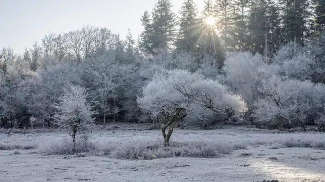
    Field and trees covered in frost and snow as temperatures drop in Lyndhurst, HampshireImage source, BBC Weather Watchers/Hang Ross

    Temperatures have plunged after a cold arctic snap spread across much of the UK. The whole of England is under amber cold weather health alerts - meaning a rise in deaths is likely.

    Met Office yellow warnings for snow and ice have been issued in England and Wales and parts of Scotland and will remain in place over the next three days. The cold snap is forecasted to continue into Monday.

    The bitter cold arrives after much of the UK was lashed by strong winds and heavy rain this week, which led to widespread flooding across the north-west of England.

    We’ll be here with all the latest updates, from travel disruption to new weather warnings - so stay with us.