Summary

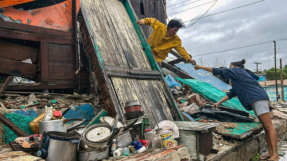
  1. Slow-moving storms are always worse because their effect lasts longerpublished at 13:07 GMT 28 October

    Elizabeth Rizzini
    Lead weather presenter

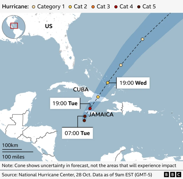
    Hurricane Melissa had been moving at 2mph (3.2 km/h) - walking pace - but it has now picked up to near 7mph as it has turned more northerly to north-easterly, as we were expecting.

    This slow speed is devastating - slow-moving storms are always worse because they last longer.

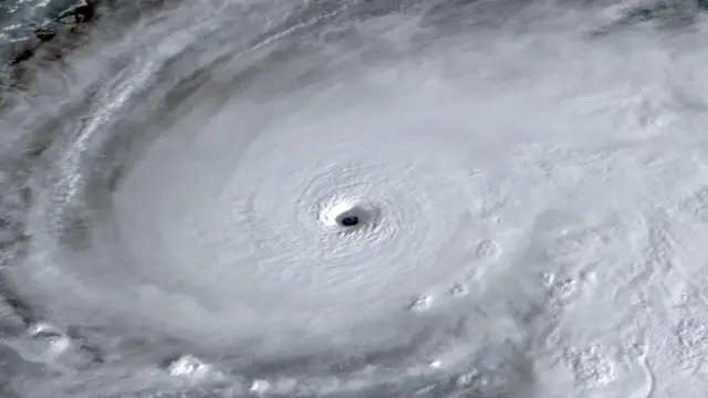
    But the slow movement does not mean the winds are slower. Melissa is a category five storm and has maintained sustained wind speeds of over 157mph (currently 175mph) for longer than 24 hours now.

    Of most concern is probably the amount of water involved. It will dump a lot of rainfall and there will be a lot of time for the storm surge to hit.

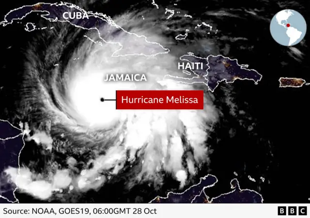
    There are low lying areas in Jamaica and it is likely there will be flash flooding not just from falling rain, but also a possible 13ft (3.9m) storm surge towards the south coast and water run-off form the mountains to lower-lying areas.

    Over the next few days, Jamaica could experience as much as 30in (76cm) of additional rain, and 25in could fall in Cuba with an 11ft storm surge.

  2. 'We've experienced a hurricane. But not one of this size'published at 12:46 GMT 28 October

    Gabriela Pomeroy
    Live reporter

    Simon JohnsonImage source, Simon Johnson

    I’ve spoken to Simon Johnson, a 33-year-old living in the Harbour View area of Kingston.

    He lives around 200m from the harbour and says he is "feeling anxious".

    “We have put plywood on the front of the house to protect against rain and wind," he says. "We have sandbags around the doors and we have tied down the shutters to protect the windows.”

    Simon, who lives with his wife and two sisters, says they know what it’s like to live through a hurricane, “but not one of this size".

    “We know it will reach us," he adds.

    He says they have stockpiled a week’s worth of food. "A lot of the supermarkets are empty. I could not find any bread in our neighbourhood. But we have tinned stuff," he says.

  3. Hurricane-force winds to hit Jamaica in next few hours, National Hurricane Center sayspublished at 12:31 GMT 28 October

    Catastrophic hurricane-force winds are expected to reach Jamaica in the next few hours, the US National Hurricane Center (NHC) says.

    The island is already experiencing tropical storm conditions, the NHC says in its latest update, adding that based on the current forecast Melissa is expected to make landfall "during the next several hours".

    It is still classifying Melissa as a category five hurricane with maximum sustained winds near 175 mph (280 km/h) – and "little change in strength is expected" before it makes landfall in Jamaica.

    The hurricane is 55 miles (90 km) away from the island but hurricane-force winds will be felt up to 30 miles (45 km) from the centre, it says.

    "Melissa is expected to reach Jamaica and southeastern Cuba as an extremely dangerous major hurricane," it says.

  4. UK Foreign Office urges Britons in Jamaica to follow local authority advicepublished at 12:16 GMT 28 October

    The Foreign Office has updated its travel advice for countries and territories across the region impacted by Hurricane Melissa.

    Airports are currently closed, and holidaymakers and British nationals residing in Jamaica are advised to follow the advice of local authorities, "especially in the event of any evacuation orders", as well as tour operators.

    The Foreign Office is also pointing people to where they can find a list of shelters on the island, external.

    The department adds that it is closely monitoring the hurricane as it approaches Jamaica, and that it "stands ready" to support partners and British nationals.

    Foreign Secretary Yvette Cooper says her department will be providing 24-hour consular assistance, and says she has spoken to Jamaica's foreign minister to offer the UK's support and solidarity.

  5. Jamaican government expects 'significant infrastructure damage'published at 12:10 GMT 28 October

    Around 1,000 people are in shelters in Jamaica as Hurricane Melissa approaches the island, a minister tells the BBC.

    Abka Fitz-Henley, State Minister in the Office of the Prime Minister, tells the BBC Newsday programme the government expects "significant infrastructure damage".

  6. Three people killed while preparing for the storm in Jamaica, official sayspublished at 11:51 GMT 28 October

    As we've been reporting, Jamaica's minister of health said yesterday that three people died in Jamaica while preparing for the approaching storm.

    "Over the past few days, in preparation for the storm we have had three deaths - three deaths linked to cutting down of trees, and in one instance electrocution because of, or due to, the cutting down of a tree," Chris Tufton said.

    In one case, a health worker was killed when a tree fell on him in St Elizabeth, according to local media. The man was airlifted to hospital but he succumbed to his injuries, the Jamaica Observer reported.

    There have also been "nearly 15" injuries linked to preparations for the storm in Jamaica, Tufton said, adding they mostly involved people falling from rooftops and trees.

    "We urge the public to exercise extreme caution: activities such as climbing roofs, securing sandbags, or cutting trees may seem manageable, but even minor mistakes during hurricane conditions can result in serious injury or death," Jamaica's Ministry of Health said.

    The storm has also been blamed for the deaths of four people in Haiti and the Dominican Republic.

  7. Hurricane will be storm of the century for Jamaica, expert sayspublished at 11:19 GMT 28 October

    Hurricane Melissa will be the "storm of the century" for Jamaica and is expected to cause a "catastrophic situation", an official from the World Meteorological Organization (WMO) says, according to Reuters.

    "It’s a catastrophic situation expected in Jamaica," the WMO's tropical cyclone specialist Anne-Claire Fontan told reporters. "For Jamaica, it will be the storm of the century for sure."

  8. The hurricane's projected pathpublished at 10:56 GMT 28 October

    A forecast map showing Hurricane Melissa’s projected path across the Caribbean. The hurricane is currently near Jamaica and is shown as a Category 5 storm (dark red dot) at 07:00 Tuesday. It is expected to move northeast toward Cuba by 19:00 Tuesday as Category 4 (red dot), then continue toward the Bahamas by 19:00 Wednesday as Category 2 (yellow dot). The map includes a cone of uncertainty extending toward the Atlantic Ocean. All times in EST (GMT-5).

    We don't know exactly when Hurricane Melissa will make landfall - the term used for when the eye of the storm reaches the coast.

    The hurricane is currently a category five storm and nearing Jamaica. The map above shows it is still forecast to be south of Jamaica at 07:00 local time (12:00 GMT).

    It is then expected to move north-east towards Cuba by 19:00 this evening (00:00 GMT) as a category four storm, before continuing towards the Bahamas around 19:00 (00:00 GMT) on Wednesday as category two.

    Satellite image showing Hurricane Melissa approaching Jamaica in the Caribbean. The storm’s eye is clearly visible, surrounded by dense white cloud bands. Jamaica is labelled near the centre, with Cuba to the northwest and Haiti to the northeast.
  9. 'The wind is so strong, part of my mum's roof has blown off'published at 10:35 GMT 28 October

    Gabriela Pomeroy
    Live reporter

    I’ve spoken to Damion, a computer scientist living in a suburban area of Kingston.

    “It was shocking to wake up to storm-force winds,” he says. “If you go outside my house right now, the winds are so strong you would not be able to stand up. It feels like hurricane-force winds coming from all directions.”

    Damion has another home in Manchester Parish, about an hour’s drive away, where his mother lives.

    “The winds have been so strong, part of the roof has lifted off,” he says.

    “I tried to protect the house before the storm hit,” Damion says. It has a metal roof, which he says he tried to reinforce, but he says he could not cover the whole thing as the hardware shops had run out of materials.

    While Damion is speaking to me, he says he can see a flash outside in the street – it is a blue light hitting an electricity wire. “It looks like an explosion of blue light,” he says. "The power just went off, but it came back on again." But he doesn't believe it was lightning.

    Damion says he is "quite scared", and that he feels he may need to go out later as he doesn’t have enough food at home and needs to stock up.

  10. Analysis

    Is Hurricane Melissa more intense due to climate change?published at 09:50 GMT 28 October

    Sarah Keith-Lucas
    Weather presenter

    The link between human-induced climate change and hurricanes is complex.

    Whilst climate change is not thought to increase the number of tropical storms or hurricanes, higher air and sea temperatures can make those that do form more intense, with stronger winds, heavier rainfall and a higher risk of coastal flooding.

    The frequency of very intense hurricanes such as Melissa is increasing, and will continue to do so as our world warms.

    In their latest assessment report, the International Panel on Climate Change (IPCC) concluded that "the proportion of Category 4–5 Tropical Cyclones will very likely increase globally with warming".

    A study from World Weather Attribution looking at hurricane Milton last year found that climate change made the winds 10% stronger and the rainfall around 20-30% more intense.

    Therefore, whilst the direct link between Hurricane Melissa and a warmer environment may be studied after the event, it is likely that it has been made wetter and windier by human-induced climate change.

  11. Watch: Satellite images track Melissa's progress to category five hurricanepublished at 09:05 GMT 28 October

    As we've been reporting, Hurricane Melissa is predicted to be one of the most powerful on record to hit Jamaica. It was upgraded to a category five hurricane - the maximum strength - early on Monday by the US-based National Hurricane Center.

    This short video clip with satellite video footage shows the storm intensifying since Sunday as it built from a category three to a category five hurricane:

  12. This is a frightening situation for Jamaica, climate minister sayspublished at 08:40 GMT 28 October

    "This is a frightening situation for Jamaica," the country's Minister of Water, Environment and Climate Change tells the BBC World Service's Newsday programme.

    Matthew Samuda says that 70% of the population lives within 5km (3.1 miles) of the sea. The storm will affect several low lying areas like Kingston, Old Harbour Bay, Rocky Point and St Elizabeth, he says.

    "We hope we have done enough in terms of preparation," he says, adding that they've spent the last week telling people about shelters around the island and to place sand bags in their homes to guard against flooding.

    Amid preparation for the hurricane, he says it has been a problem convincing people to go to shelters as they feel they must "protect their property as opposed to preserving their lives first".

    Samuda implores for those in the diaspora to call family members "before it's too late".

  13. Analysis

    What is the eyewall of a hurricane?published at 08:23 GMT 28 October

    Elizabeth Rizzini
    Lead weather presenter

    Media caption,

    Watch: Storm chasers fly inside the eye of Hurricane Melissa

    The eye of Melissa is still to the south of Jamaica. We say a hurricane makes landfall when the eye reaches the coast.

    A hurricane, like other tropical cyclones, mainly consists of the outer rainbands, the eye and the eyewall.

    Within the hurricane, air spins in an anti-clockwise direction in the northern hemisphere and then spills out of the top of the storm. So, in the very centre of the storm, air sinks.

    The eye of the storm is relatively calm with light winds and, as you can see on satellite pictures, cloud free. Hurricane hunter planes fly into the eye to gather data on wind speed and atmospheric conditions.

    The eyewall, rapidly ascending air, is around the air and helps to form the vacuum in the eye. It contains the strongest winds and consists of a ring of tall thunderstorms.

    The lull in the eye of the hurricane can provide a false sense of security with the other part of the eyewall yet to come crashing through. Migrating birds can sometimes get trapped in the eye.

    Sometimes in a hurricane, the eyewall can be replaced and this has been forecast with Melissa. When this happens, the storm weakens for a while as the inner eyewall collapses.

    It can be replaced by another outer eyewall, which can allow the hurricane to re-intensify and become more stable and sometimes larger.

  14. The birds have all gone, says British mum stuck in Jamaicapublished at 08:12 GMT 28 October

    Mary Litchfield
    UGC & Investigations

    We've been hearing from more British tourists who are stuck in Jamaica.

    Rebecca Chapman, in Jamaica for her 25th wedding anniversary, told BBC Radio 4’s Today programme she and her family arrived on Thursday evening - just as preparations for the storm began.

    She's staying with her husband and three teenage sons in Lucea, about 30 minutes from Montego Bay, in a hotel that's spread across the coastline.

    Their room is about 10m from the sea and the hotel is moving them to a different room that is more sheltered.

    Quote Message

    We’re in our rooms and have been told not go out; it doesn’t feel like it's here, but you know it’s coming."

    Flying home before the hurricane “isn’t even an option; we’re stuck”, she says

    "The weirdest part of all of it is whilst the sea is really rough and it was really windy, now it’s stopped," Rebecca says.

    "There’s this weird roar that sounds like it’s coming from the sea. It’s really odd, like something’s coming. The birds have all gone so it’s all gone really quiet. It's like a ghost town."

  15. Hurricanes are common for Jamaica - but direct hits are rarerpublished at 07:59 GMT 28 October

    Sarah Keith-Lucas
    Weather presenter

    Although hurricanes are a recurring threat to Jamaica, it is likely that Hurricane Melissa could be the strongest storm on record to hit the island, causing catastrophic damage and bringing life-threatening storm conditions.

    Due to its location in the warm tropical waters of the western Caribbean, tropical storms and hurricanes are an annual threat to Jamaica.

    Hurricane season runs from June to November, and peaks in Jamaica in the second half of October.

    Most years the island will feel the impacts of two or three tropical storms or hurricanes, but it is relatively rare for these storms to make a direct landfall.

    Only three hurricanes have directly hit Jamaica since 1988.

  16. Are you affected? Get in touchpublished at 07:58 GMT 28 October

    Your voice, your BBC News banner

    If it is safe to do so, tell us how you have been affected by Hurricane Melissa

    In some cases a selection of your comments and questions will be published, displaying your name and location as you provide it unless you state otherwise. Your contact details will never be published.

  17. 'You get a real sense something incredibly serious is about to happen': British tourist stuck in Jamaicapublished at 07:54 GMT 28 October

    Mary Litchfield
    UGC & Investigations

    Alex Baskeyfield, from West Yorkshire, never expected to get caught in a hurricane during his trip to Jamaica with his wife and 13-year-old daughter.

    Quote Message

    It is incredibly daunting because the storm has intensified so quickly."

    Alex, who is currently staying in the town of Negril on the west of the island, tried leaving Jamaica but airports have been closed and the few departing flights were fully booked.

    He adds there are "extreme preparations" as windows have been shuttered with wood, everything has been tied down and ceiling fans and televisions have been taken off.

    "There’s been an army of people for the last 48 hours unscrewing anything they could," he says.

    "You do get a real sense that something incredibly serious is about to happen. It’s so strange and unusual for us."

  18. Gusts and intermittent rain in Kingston, BBC reporter sayspublished at 07:35 GMT 28 October

    The BBC's Nick Davis has sent us this short video from the Jamaican capital, Kingston, where he says there are gusts and intermittent rain.

    People on the ground are feeling strong gusts of wind and rain, but the full extent of the storm has not yet hit them.

  19. What's the latest on the hurricane?published at 07:21 GMT 28 October

    Elizabeth Rizzini
    Lead weather presenter

    A satellite view shows Tropical Storm Melissa, over the Caribbean Sea, October 27, 2025, in this screengrab obtained from a handout video.Image source, CSU
    Image caption,

    A satellite view shows Tropical Storm Melissa over the Caribbean Sea

    The eye wall is still to the south of Jamaica and much of the island is already under tropical storm conditions.

    The storm is very slow moving at only 2mph (3.2km/h) in a north-easterly direction. Now that it has turned northwards, it could speed up a little.

    The current sustained wind speeds are 175mph (282km/h) with higher gusts. It is an extremely dangerous category five hurricane. It's the strongest storm on Earth so far this year in terms of wind speeds and central pressure, which is currently just 901 millibars.

    Landfall is expected later today in Jamaica and catastrophic and life-threatening hurricane-force winds are expected to begin this morning.

    There will be another 15 to 30 inches of rainfall for Jamaica with a storm surge of up to 13ft near landfall on the south coast with large and destructive waves. On the north-west coast, near Montego Bay, there could be a 2ft to 4ft storm surge. We are expecting landslides and catastrophic flooding.

    For Haiti, tropical storm conditions will begin later today too, with 6-12in of rainfall.

    The storm will move northwards very slowly bringing further rain and will then make landfall again in south-eastern Cuba, still as a major hurricane.

    Swells generated by Melissa are expected to affect portions of Hispaniola, Jamaica, eastern Cuba, and the Cayman Islands during the next several days, likely causing life-threatening surf and rip current conditions.

    These swells will reach the Bahamas, the Turks and Caicos Islands, and Bermuda later this week.

  20. Why is Melissa such a dangerous and impactful storm?published at 07:09 GMT 28 October

    Sarah Keith-Lucas
    Weather presenter

    A man wearing a protective suit cycles on a street, as Hurricane Melissa approaches, in Kingston, Jamaica, October 27, 2025Image source, Reuters
    Image caption,

    A man wearing a protective suit cycles on a street in Kingston overnight

    Melissa is a particularly powerful, large and slow-moving hurricane, and there are several reasons why:

    Warmer waters

    Hurricanes need warm waters to provide their fuel, and higher heat on the sea surface has been injecting extra energy into the storm system. The waters in the western Caribbean are currently close to 30C, around two to three Celsius above average for the time of year.

    Lack of wind shear

    The winds in the atmosphere surrounding the hurricane are not changing very much with height, and this lack of wind shear has played an important role in allowing the hurricane's extensive growth.

    When wind shear is greater, it tends to rip storms apart and allow them to weaken, but in this set up, Hurricane Melissa has been able to continue building and strengthening for several days.

    Slow-moving

    The 'steering winds' driving the hurricane forward are relatively weak.

    This means that the storm system is moving forward slowly, at less than 4mph (6.4kmph), and so lingering over particular areas for a long time and continuing to produce torrential rainfall and destructive winds that would typically move through quicker with a faster-moving storm.