Summary

  • Tropical storm Idalia is crossing into Georgia, bringing powerful winds and potentially life-threatening conditions

  • President Joe Biden warns Idalia, which hit Florida as a Category 3 hurricane, is "still very dangerous"

  • More than 440,000 people are without power in Florida and Georgia

  • There are no confirmed fatalities from the storm – however Florida Highway Patrol has reported the deaths of two drivers in crashes caused by rainy conditions

  • Some areas of Florida have been flooded, and the National Hurricane Center warns storm surge still threatens coastal areas

  • The head of the Federal Emergency Management Agency says Idalia is the strongest storm to hit this part of Florida in more than 100 years

  • You can watch live pictures from around Florida by clicking the play button at the top of this page

  1. Evacuation orders in force across Floridapublished at 05:01 British Summer Time 30 August 2023

    Evacuation orders are in force in more than 20 counties in the state of Florida, as they brace for the extreme hurricane to make landfall on Wednesday morning.

    It's predicted to lead to a storm surge, generating waves almost 10 ft (3m) high along the Gulf coast.

    Idalia, currently a Category 2 storm, is forecast to reach an "extremely dangerous Category 4 intensity". The National Hurricane Centre added that "destructive life-threatening winds" may also result.

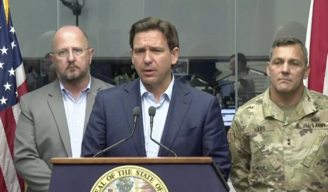
    Florida Governor Ron DeSantis has urged people in low-lying areas to move to higher ground before it is too late, and has deployed National Guard troops to help with the aftermath.

  2. Hurricane Idalia forecast to intensify to Category 4published at 04:25 British Summer Time 30 August 2023

    Idalia, currently a Category 2 storm, is forecast to reach an "extremely dangerous Category 4 intensity", said the National Hurricane Center in its latest update.

    It is projected to make landfall in the Florida Big Bend region with "catastrophic storm surge inundation".

    "Residents should heed advice & evacuation orders by local officials in these areas," it added.

  3. Conditions getting worse along Florida coastpublished at 04:01 British Summer Time 30 August 2023

    Mike Wendling
    in Tampa

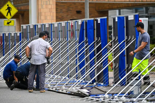
    Workers set up a fence to prevent flooding at Tampa General Hospital earlier TuesdayImage source, Getty Images
    Image caption,

    Workers set up a fence to prevent flooding at Tampa General Hospital earlier Tuesday

    Here in Tampa, the weather has steadily deteriorated as the night has gone on. The wind and the rain are slowly intensifying.

    It’s a serious storm but it could be worse. As of now, there are no reports of large-scale power outages or tornados.

    That said, there’s still a long way to go. Rain is sweeping across large parts of the southwest Florida coast, even though the centre of Idalia is still more than 100 miles (160km) offshore.

    And residents are bracing for a predicted storm surge tomorrow. The hurricane is expected to push water into Tampa Bay, coinciding with the high tide and flooding low-lying areas. People near the coast and those living in mobile homes have been told to leave.

    Further north, the surge could be much higher and the effects far worse.

  4. Disney closes water park ahead of Idaliapublished at 03:29 British Summer Time 30 August 2023

    A sign near an entranceway to Walt Disney World on MAY 22, 2023 in Orlando, Florida.Image source, Getty Images

    One of Florida's most popular attractions, Walt Disney World in Orlando, will close some of its parks in anticipation of Hurricane Idalia., external

    Disney's Typhoon Lagoon water park will be closed on Wednesday due to the "inclement weather", the company announced in a memo.

    Its miniature golf pitches - Winter Summerland and Fantasia Gardens - will also be closed.

    The rest of the parks at Walt Disney World are expected to operate as per normal, but the company says it will continue to monitor the path of the hurricane and adjust its schedule accordingly.

    On Tuesday, the City of Orlando said the path of Idalia and its impact on the city itself remained "uncertain"

    Non-essential services and city hall, however, will be closed on Wednesday as a precaution.

  5. Electric vehicles catch fire in floodwater, DeSantis warnspublished at 02:58 British Summer Time 30 August 2023

    Earlier during a storm update, Florida Governor Ron DeSantis warned residents that electric cars could pose a fire risk.

    "Electric vehicles, when they face saltwater intrusion, can catch on fire," he said.

    EV fires are "not like a normal fire" and are "very difficult to put out", he added.

    The governor cited an example of an EV user, whose vehicle caught fire and burnt down their house in the aftermath of Hurricane Ian last year.

  6. The calm before the storm, in picturespublished at 02:06 British Summer Time 30 August 2023

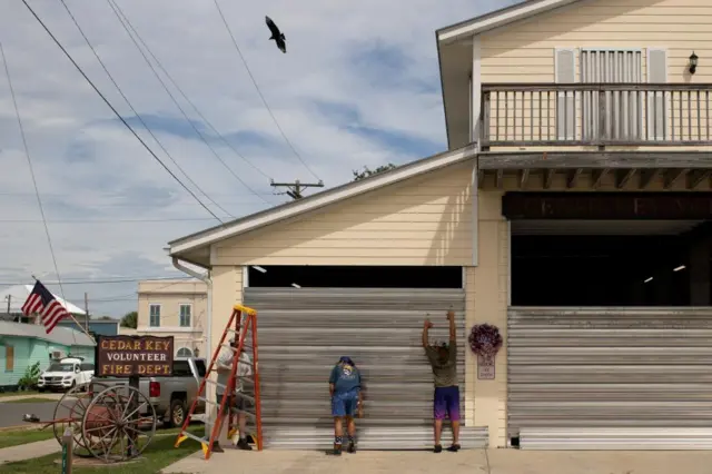
    As Hurricane Idalia makes its way towards Florida's Big Bend, residents are taking as many precautions as possible to shield themselves from the impact.

    Here, volunteers are seen placing hurricane shutters at the Cedar Key Fire Station ahead of the arrival of the storm.

    Cedar Key is one of the regions projected to be hit with the highest storm surge - up to 15ft.

    Volunteers place hurricane shutters at the Cedar Key Fire Station ahead of the arrival of Hurricane Idalia, in Cedar Key, Florida, U.S., August 29, 2023.Image source, Reuters

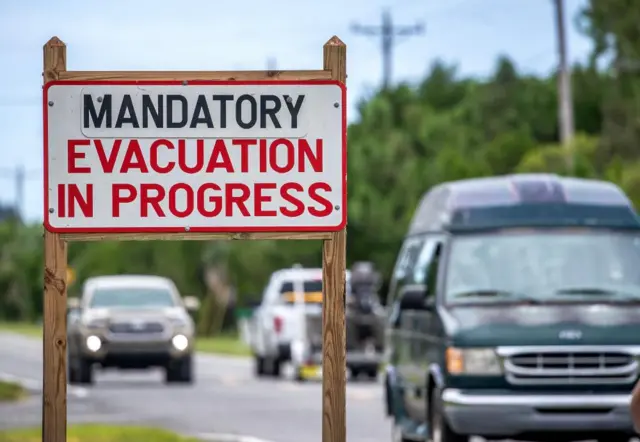
    Twenty-eight counties out of Florida's 67 are under some form of evacuation order, impacting more than 1.5 million people in the Sunshine State.

    Vehicles move nex to a 'mandatory evacuation' sign, as the town prepares for Hurricane Idalia, in Cedar Key, Florida, USA, 29 August 2023. Hurricane Idalia is forecast to make landfall in northwest Florida on 30 August as a Category 3 major hurricane.Image source, EPA

    To prepare, some Floridians, like Nazih Tageddine from Clearwater Beach, spent their Tuesday afternoon wrapping cellophane around their gas pumps to prevent them from being damaged in the rain, as Idalia passes through.

    Nazih Tageddine wraps cellophane around his gas pump to prevent it from being damaged by the rain from Hurricane Idalia as it passes offshore on August 29, 2023 in Clearwater Beach, Florida. Hurricane Idalia is forecast to make landfall on the Gulf Coast of Florida Wednesday morning.Image source, Getty Images

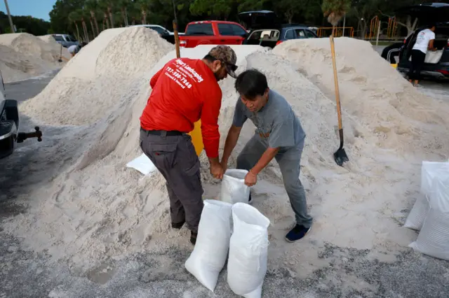
    Others, like Edgar Rocha (L) and Paul Xy, filled sandbags - a tool commonly used in hurricane preparations to help divert water away from homes and businesses.

    Edgar Rocha (L) and Paul Xy fill sandbags at the Helen S. Howarth Community Park ahead of the possible arrival of Hurricane Idalia on August 29, 2023 in Pinellas Park, Florida.Image source, Getty Images
  7. The latest on Hurricane Idaliapublished at 01:39 British Summer Time 30 August 2023

    The National Weather Service has given its latest update, external on the status of Idalia. Here's what they said:

    • Idalia continues to strengthen and will probably become a major hurricane soon
    • As of Tuesday evening local time, the hurricane about 155 miles (250 kilometres) southwest of Tampa, Florida
    • It is still expected to reach the Big Bend area of Florida on Wednesday morning, before moving northeast near the coasts of Georgia, South Carolina and North Carolina through Wednesday and Thursday
    • Its maximum sustained winds have increased to 105mph (165km/h), meaning it remains a Category 2 as of Tuesday evening, though it is expected to strengthen to Category 3 before it makes landfall
    • Floridians in impacted areas are expected to feel hurricane conditions as early as Tuesday evening
    • In his latest update, Governor Ron DeSantis said 28 of Florida's 67 counties were under evacuation orders
  8. Hurricane centre chief says storm 'may be worse than people envisioning'published at 01:00 British Summer Time 30 August 2023

    Media caption,

    Hurricane expert: Storm surges may be 'life threatening'

    Jamie Rhome of the National Hurricane Center has told BBC News that the seriousness of the incoming hurricane may be beyond the scope of understanding for some Floridians.

    "For some communities [this] is probably going to be worse than they're envisioning, because so few people understand the power of a major hurricane," he said, referring to residents of the Big Bend region and cities like Tallahassee and Tampa.

    A storm surge of 10-15ft (4.5m) "is hard for a lot of people to fathom and envision", he says.

    Rhome, who is 6ft tall, asked BBC audiences to imagine another one or more people standing on his shoulders to get a picture of the expected depth of some floodwaters.

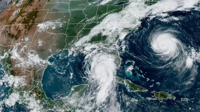
  9. US caught in the eye of two stormspublished at 00:33 British Summer Time 30 August 2023

    Hurricanes Idalia and FranklinImage source, Reuters

    Idalia is not the only major system currently surging across the Atlantic. Hurricane Franklin is also out there, and is producing winds of 125 mph (200km/h)

    Franklin was declared the first major Atlantic hurricane of the season on Monday. It was initially deemed to be a Category 4 storm threatening to bring heavy swells to Bermuda and the US east coast throughout the week.

    According to the National Hurricane Center, "life-threatening surf and rip currents" are ongoing along the US's east coast, and a tropical storm warning has been issued for Bermuda.

    However, the latest public advisory issued by the hurricane centre says that the storm is expected to weaken in the coming days and has been downgraded to a Category 3 hurricane.

  10. How big could the storm surge be?published at 00:20 British Summer Time 30 August 2023

    Media caption,

    Watch: How quickly water rises in a storm surge

    The National Hurricane Center warns that a storm surge could be has high as 15ft (4.5m).

    To put it into perspective, that is about half the length of the famous London double-decker red buses.

    If the 7ft 1in NBA hall-of-famer Shaquille O'Neal stood on his own shoulders - he would still be underwater.

    A two storey house is usually about 20-25 ft tall.

  11. The calm before the stormpublished at 00:10 British Summer Time 30 August 2023

    Mike Wendling
    Reporting from Tampa, Florida

    Tampa's streets are empty before Idalia moves into the area
    Image caption,

    Tampa's streets are empty before Idalia moves into the area

    There’s an eerie late afternoon feeling on the streets of Tampa, Florida.

    A light rain is falling and the wind has only just started to pick up.

    Normally this would be the start of rush hour. There are a few vehicles on the roads, but most downtown shops have shut and the sidewalks are empty.

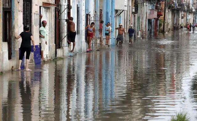
    Idalia has caused flooding in Cuba and is already lashing parts of Florida, but here the worst weather is expected to come overnight into tomorrow. A potential storm surge could come any time through Wednesday afternoon.

    People here are watching and waiting.

    A barometer in downtown Tampa shows "Change"
  12. WATCH: 'St Elmo's Fire' spotted over Tampapublished at 23:57 British Summer Time 29 August 2023

    Media caption,

    Rare footage of St Elmo's Fire as hurricane approaches

    This video shows the incredible weather phenomenon known as St Elmo's fire.

    The near-constant eruptions of purple bolts of light was filmed from a MacDill Air Force Base aircraft as it flew through the heavily charged Tampa skies.

    Like lightning, St Elmo's fire emits a glowing discharge of ionised air.

    The air base said in a post on X, external, formerly known as Twitter, that the luminous plasma is created in an atmospheric electric field.

    The impending arrival of Hurricane Idalia has forced the mandatory evacuation of military families and non-essential staff from MacDill Air Force Base.

    MacDill is home to two combatant commands: the US Central Command and the US Special Operations Command.

    It also houses more than two dozen other military units.

    The air base confirmed all its aircraft on site had been "evacuated/secured" before Idalia makes landfall.

  13. What we learnedpublished at 23:37 British Summer Time 29 August 2023

    Here's a quick recap of that update from Florida Governor Ron DeSantis:

    • Hurricane Idalia has shifted westward and will impact parts of Florida further north
    • The Big Bend area will definitely be impacted by the storm, potentially by its eyewall
    • A storm of this magnitude hasn't hit the area since the 1800s
    • The storm makes landfall on Wednesday morning, but its impacts will be felt through the night and residents under evacuation orders should leave now
    • There are now 28 of Florida's 67 counties under evacuation orders
    • In addition to the 5,500 members of Florida's National Guard who are on standby, Guardsmen from Tennessee and South Carolina have also been activated in the state
    • Bridges will be shut down to traffic by state police once winds hit 40 mph (65 km/h)
    • Hotels have been instructed to let guests bring pets with them when they seek out shelter; each county also has at least one pet-friendly shelter available
  14. Floridians told to fear the 'historical flood surge'published at 23:27 British Summer Time 29 August 2023

    Officials say they are concerned that some residents may not be taking the warnings seriously because it has been generations since a similar threat loomed in the Big Bend region.

    "You really gotta go back to the late 1800s to find a storm of this magnitude that will enter where this one looks like it's going to enter tomorrow," says DeSantis.

    "So we don’t really have historical analogue in anybody’s memory, so it looks like its going to cause a lot of damage. That’s just the reality."

    Kevin Guthrie of the Florida Division of Emergency Management said residents should expect to see a "historical flood surge up into the Big Bend area".

    He notes that the possibility of 15ft (4.5m) flood surge, which is 3ft (1m) higher than the predictions for Hurricane Ian at Fort Myers Beach in 2022.

    DeSantis ended the press conference by once again warning Florida residents to "be ready for impact".

  15. Bridges will close once winds increasepublished at 23:13 British Summer Time 29 August 2023

    State police and transport authorities will shut down bridges to all traffic once winds hit 40mph (65km/h), says DeSantis.

    At winds that high, "those bridges will not be safe to traverse," the governor says.

    He also says hotels have been instructed to let guests bring their pets with them, the governor says, while each county will also have at least one pet-friendly shelter.

  16. Evacuate now, because tomorrow's conditions will be 'too nasty'published at 23:08 British Summer Time 29 August 2023

    DeSantis says that residents that don't leave tonight, will not be able to do so until the storm passes later on Wednesday.

    The major impact of the storm is expected to arrive on Wednesday morning.

    "If you hunker down tonight, it's going to be too nasty tomorrow morning" to evacuate, he said.

    Emergency rescue crews are "not going to be able to get there until after the storm has passed," he says, asking people to consider the safety of their family as they make their plan.

    "You don’t need to travel hundreds of miles away, you don’t need to outrun the storm," he continued, advising people to simply seek higher ground.

    There are now 28 counties under evacuation orders.

    If the storm hits at high tide, the surge could reach as high as 15 feet (4.5m).

    "If you are there when that hits it's going to be very difficult to survive that," he says.

  17. 'Definitely hitting the Big Bend'published at 23:06 British Summer Time 29 August 2023

    Ron DeSantis speaks at latest press conferenceImage source, None

    Florida Governor Ron DeSantis is at the podium for his next update.

    Hurricane Idalia is now about 190 miles (305 km) southwest of Tampa and is intensifying, he says.

    Forecast models are in agreement that the storm has shifted westward and will hit parts of the state that are further north.

    DeSantis warns the Big Bend area is definitely going to be hit by Idalia, and could be caught in the eye of the storm.

  18. Another update from Florida expected soonpublished at 23:01 British Summer Time 29 August 2023

    We're expecting another news conference from Florida Governor Ron DeSantis and his top officials as they brace for Idalia to make landfall.

    DeSantis is currently in Tallahassee, the state capital. The city is now likely to be impacted by Idalia, with the most recent forecasts showing the hurricane has shifted westward.

    You can watch the livestream by pressing the Play button at the top of this page.

    Stay tuned as we bring you the latest updates.

  19. Idalia hits Cuba before heading to USpublished at 22:39 British Summer Time 29 August 2023

    A flooded car in HavanaImage source, Reuters
    Image caption,

    Flooding was also seen in the capitol, Havana

    Western Cuba was hit by the start of the storm overnight, and local authorities declared alerts in several of the country's western provinces.

    Thousands of people were evacuated from flooded villages and damaged homes, according to reports.

    A small fishing village an hour's drive south of Havana has been soaked in brown floodwaters, the Reuters news agency reports. In Pinar del Rio, where tobacco is produced, some 60% of the province was without power.

    According to Granma, a Cuban newspaper, preliminary data suggests that more than 4,000 people were impacted by power outages due to heavy winds caused by the storm.

    Reservoirs were also reported to have been filled up rapidly in the early hours, with some reaching more than 60% of their capacity.

    The Cuyaguateje river was reported to breach its banks and cut off several nearby towns.

    People in Havana near floodwatersImage source, Reuters
  20. Extreme wind warning likely to be issuedpublished at 22:09 British Summer Time 29 August 2023

    The National Weather Service says it may issue an extreme wind warning as the forecast for Idalia's path and impact grows clearer.

    Extreme wind warnings are issued when hurricane-force winds are imminent or happening now, with sustained speeds of up to 115 mph (185 km/h) or greater.

    The NWS adds that those under such a warning must "take immediate shelter in an interior portion of a well-built structure".