Sharp-eyed Pleiades returns first pictures
- Published
- comments

Just days after its launch on a Soyuz rocket, the new French high-resolution Pleiades imaging satellite has sent down its first pictures.
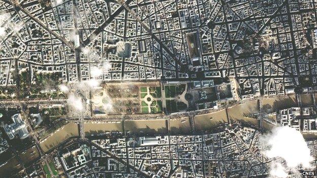
One of the shots released by the French space agency (Cnes), external is of central Paris, showing the Louvre and the Place De La Concorde - "naturellement".
The Pleiades project has been in development for the best part of a decade.
It will produce pictures that have a resolution of 50cm after processing. That is - details on the ground as small as half a metre are discernable.
The spacecraft will give Europe a high performance capability to rival that of the Americans.
The market for sub one metre satellite imagery has become dominated in recent years by two US companies - DigitalGlobe, external and GeoEye, external.
Many of the pictures you see on Google and Bing maps, and indeed on the BBC News website, are sourced from these two operators.
Pleiades will go head-to-head with the Americans and has a number of clever tricks that should enable it to win a sizeable market share.
One of these tricks is the ability to swivel its instrument in quick time to acquire a strip, or mosaic, of images around its target in a single pass overhead.
So whereas the nominal maximum width in an image is 20km, Pleiades can scan the ground rapidly to effectively build up a much wider swath at any given point.
"Pleiades is equipped with control moment gyros," explained Charlotte Gabriel Robez, the Pleiades project manager with Astrium Geo-information Services, external.
"These devices allow Pleiades to slew very fast from a point A to a point B," she told me.
"Imagine there is 200 km between those two locations - if you have these control moment gyros, you only need 11 seconds to switch. If you do not have them, you need around 20 seconds. This means that when you fly over a given area, you can acquire double the number of images than would normally be the case.
"So, we can collect either plenty of different images over a narrow area, or we can 'paint' a large area 100km by 100km.
"We can even acquire several images of the same place in the very same pass, meaning that we can build up 3D models of the ground thanks to the different viewing angles."
A second satellite will launch in 2013 and its orbit around the globe will be off set from the first by 180 degrees. This will then allow the Pleiades system to take a picture of any place on Earth every day…assuming there's no cloud over the target.
Expect Pleiades pictures to become a common feature in newspapers and on websites like this one in the years ahead.

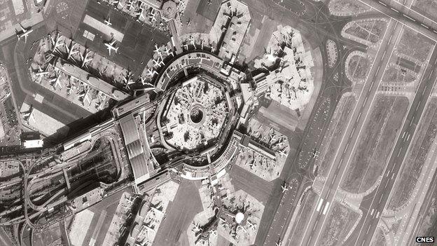
San Francisco Airport. Pleiades' high resolution instrument is equipped with British-built sensors
The satellites have been assembled by Astrium, Europe's largest space company, with their sharp-eyed instruments supplied by Thales Alenia Space, external (France).
Although a French national programme, Pleiades has drawn funding from a number of other European nations.
The UK is not involved programmatically but one of its companies, e2v, external, has sold some critical technology into the project - the Charge Coupled Devices (CCDs) on the imaging instruments.
CCDs are the camera sensors. They turn the light falling on their surface into an electronic signal that can be transmitted to the ground where they are turned back into an image on a computer screen.
"We developed a new CCD image sensor here in the UK for the Pleiades panchromatic channel - the high resolution part of the imaging system. It's called a time delay and integration device," e2v's chief engineer, Dave Morris, told me.
"It has 10 outputs and 6,000 pixels in a line, and they use five of them to cover the whole swath of a Pleiades image.
"I did the initial design study in 2001 and we started the development in 2002. We did a vast amount of qualification work. You have to remember that this is a nationally significant mission for France and the CCDs absolutely had to work.
"We delivered the final flight models in 2007. It was a challenging specification and we took a major technological step forward with these CCDs, and it's worked out really well as you can see from the new pictures."
It's been a noteworthy couple of months for e2v, who are based in Chelmsford in the East of England.
In November, their sensors were launched on Nasa's Mars Science Laboratory, the next big thing at the Red Planet. The sensors will be used on a couple of MSL's instruments, including one that can identify the chemistry of rocks from a distance simply by firing a laser at them.

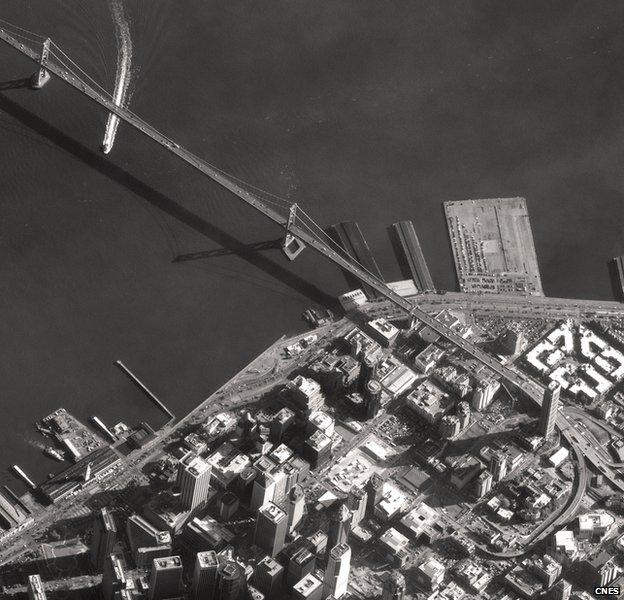
The "Paris of the West". A view of the Bay Bridge heading out of San Francisco