Jet stream changes may bring warmer weather to UK
- Published
Following three months of miserable weather blamed on a stuck jet stream pattern which has brought record breaking rainfall across the British Isles, things are about to change.
The jet stream is likely to change course soon, ending the UK's spell of miserable weather, forecasters say.
The UK is expected to get drier and warmer next week but only after more rain hits an already record summer.
This year has seen the wettest April, the wettest June and the wettest April-to-June period on record.
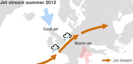
The cause has been the unusually southerly location of the jet stream, a high-altitude belt of wind; but it is expected to move northwards soon.
This should bring more normal summer weather - probably in time for the Olympics.
"Around the middle of next week, pressure will build - the Azores high," said BBC weather presenter Cecilia Daly.
"This would allow our weather to take on more normal summer characteristics."

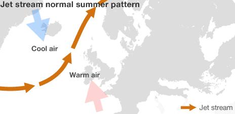
The jet stream normally sits to the north of the UK in summer, directing areas of low pressure and bad weather further north.

The jet stream has been further south than usual this summer, bringing wet and cold weather to much of the country
But changeable weather can be expected until that point, especially in north-western parts of the UK.
The anticipated change would put an end to an intense period that has seen serious flooding in most parts of the UK, with several areas experiencing an entire month's rain in a single day.
At one point earlier this month, the Environment Agency issued flood warnings in 171 locations simultaneously.
The trend has continued in early July, with England and Wales both experiencing above average rainfall.
Speedier flights
There are four jet streams circling the globe, two each in the northern and southern hemispheres.

While the UK has been drenched, large swathes of the US have been unseasonably hot
They flow at an altitude of about 7-10km (4.5-6 miles) from west to east.
Aircraft flying from North America to Europe typically take advantage of the northern hemisphere polar jet to speed their journeys.
The jet stream's path is far from uniform and its location can vary.
In summer it usually sits to the north of the UK, making British weather a slightly cooler version of what continental Europe is experiencing.
But for much of 2012, it sat much farther south. The high-velocity wind effectively sucked moisture from the Atlantic Ocean and kept the UK cool and wet.
Effects have been very different on the other side of the Atlantic. <link> <caption>More than half of the US is in drought</caption> <url href="http://www.bbc.co.uk/news/world-us-canada-18864753" platform="highweb"/> </link> and disasters have officially been declared in 1,000 counties spanning 26 states.
As the jet stream moves northwards, as it is expected to do, the UK's weather should return to a more conventional pattern.
"What that means is it's taking those weather systems further north with it, so things should really settle down a little bit more over the south," said Dave Britton of the Met Office.
"But [it will be] bringing more in the way of wet conditions to northwest Scotland."
- Published10 July 2012
- Published10 July 2012
- Published6 July 2012
- Published3 July 2012