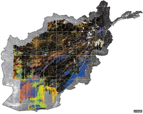
Afghanistan minerals fully mapped
- Published

The data distinguish a range of different minerals and snow or vegetation cover
Afghanistan has become the first country whose surface minerals have been mapped from the air.
The US Geological Survey released the results of a "hyperspectral imaging" effort, in which reflections of light from the ground are analysed.
Different minerals - as well as snow or vegetation - reflect specific colours, resulting in a "mineral map".
The map comprises more than 800 million data points corresponding to an area of 440,000 sq km, some 70% of the country.
Afghanistan is known to have vast reserves of oil, gas, copper, cobalt, gold and lithium. In late 2011, a consortium of Indian companies <link> <firstCreated>2011-11-29T11:41:12+00:00</firstCreated> <lastUpdated>2011-11-29T11:41:12+00:00</lastUpdated> <caption>inked a deal</caption> <url href="http://www.bbc.co.uk/news/world-asia-15936402" platform="highweb"/> <url href="http://www.bbc.co.uk/news/mobile/world-asia-15936402" platform="enhancedmobile"/> </link> to begin mining some of the country's large stores of iron.
But the country is known to have a wider array of mineral resources; in 2010, the Afghan ministry of mines <link> <firstCreated>2010-06-14T14:48:59+00:00</firstCreated> <lastUpdated>2010-06-14T17:17:58+00:00</lastUpdated> <caption>claimed a value of its reserves</caption> <url href="http://www.bbc.co.uk/news/10311752" platform="highweb"/> <url href="http://www.bbc.co.uk/news/mobile/10311752" platform="enhancedmobile"/> </link> of nearly a trillion dollars, then carrying out <link> <firstCreated>2010-06-25T09:24:56+00:00</firstCreated> <lastUpdated>2010-06-25T09:24:56+00:00</lastUpdated> <caption>tours to promote investment in them</caption> <url href="http://www.bbc.co.uk/news/10412085" platform="highweb"/> <url href="http://www.bbc.co.uk/news/mobile/10412085" platform="enhancedmobile"/> </link> .
But it remains to pin down which economically viable minerals are where, an effort for which the USGS's hyperspectral imaging expertise was enlisted.
In a series of 28 flights over 43 days, the USGS gathered the data from a height of 15,000m, using a camera to capture sunlight reflected from the ground. Each "pixel" of the camera was analysed and correlated with the materials that reflect at a given colour.
The USGS public release of the data includes two maps: <link> <caption>one of iron and iron-bearing minerals</caption> <url href="http://pubs.usgs.gov/sim/3152/B/" platform="highweb"/> </link> , and <link> <caption>one of minerals principally containing carbon, silicon, or sulphur</caption> <url href="http://pubs.usgs.gov/sim/3152/A/" platform="highweb"/> </link> .
The survey was funded by the US Department of Defense's Task Force for Business and Stability Operations (TFBSO) as well as the Afghan government.
"This is a tremendous tool for the Afghan government for locating and identifying its myriad rich mineral deposits," said TFBSO director Jim Bullion.
"These maps clearly show the enormous size and variety of Afghanistan's mineral wealth and position the country to become a world leader in the minerals sector."
- Published6 June 2012
- Published29 November 2011
- Published25 June 2010
- Published14 June 2010