Met Office three-month forecast was 'not helpful'
- Published

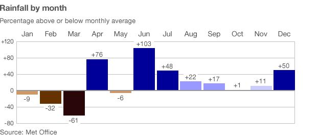
Between March and April 2012, the UK experienced an extraordinary shift in pressure and downpours
The Met Office has admitted issuing advice to government that was "not helpful" during last year's remarkable switch in weather patterns.
Between March and April 2012, the UK experienced an extraordinary shift from high pressure and drought to low pressure and downpours.
But the Met Office said the forecast for average rainfall "slightly" favoured drier than average conditions.
The three-month forecast is said to be experimental.
It is sent to contingency planners but has been withheld from the public since the Met Office was pilloried for its "barbecue summer" forecast in 2009.
Last spring's forecast has been obtained by BBC News under Freedom of Information.
The Met Office three-monthly outlook at the end of March stated: "The forecast for average UK rainfall slightly favours drier than average conditions for April-May-June, and slightly favours April being the driest of the three months."
A soul-searching Met Office analysis later confessed: "Given that April was the wettest since detailed records began in 1910 and the April-May-June quarter was also the wettest, this advice was not helpful."
In a note to the government chief scientist, the Met Office chief scientist Prof Julia Slingo explains the difficulty of constructing long-distance forecasts, given the UK's position at the far edge of dominant world weather systems.
She says last year's calculations were not actually wrong because they were probabilistic.
The Met Office forecast that the probability that April-May-June would fall into the driest of five categories was 20-25%, whilst the probability it would fall into the wettest was 10-15% (The average probability would be 20%).
The Met Office explained it this way: "The probabilistic forecast can be considered as somewhat like a form guide for a horse race.
'Unsolved challenges'
"It provides an insight into which outcomes are most likely, although in some cases there is a broad spread of outcomes, analogous to a race in which there is no strong favourite. Just as any of the horses in the race could win the race, any of the outcomes could occur, but some are more likely than others."
It said: "The creation of the three-monthly outlook relies upon the fact that weather is influenced by the slow variation of ocean conditions (and other processes) which can be predicted months in advance.

"Whilst there is a very strong dependence of tropical weather on processes such as El Nino ,the UK's weather is dominated by the highly variable atmospheric circulation over the North Atlantic, making it much harder to predict what will happen weeks and months ahead."
In the case of last spring, Prof Slingo says the forecast may have been pushed awry by a little-understood climate phenomenon, the Madden Julian Oscillation (MJO), external - a pattern of thunderstorms that starts in the Indian Ocean. The Met Office calls it "one of the great unsolved challenges of tropical meteorology".
The irregular phenomenon is an envelope of thunderstorms starting in the Indian Ocean and moving into the Pacific. The MJO concentrates tropical rainfall within the envelope, with blue skies around it.
Speaking to BBC Radio 4's Today programme, Prof Slingo also said a serious pressure on water resources in March did mean a "slightly enhanced risk" of the drought continuing into April.
"I felt it was right to emphasise the risk of dry conditions continuing as a precautionary principle," she added.
"We have to look over a large number of events and I think on about 65% of occasions we do give indeed very helpful advice."
Thunderstorm activity
Nick Klingaman from Reading University says that, as it moves east, the MJO influences monsoon rainfall in Australia, India, Southeast Asia, South America and Africa.
These "bursts" and "breaks" in the monsoon cause floods and droughts that impact agriculture, river systems and infrastructure. The "long arm of the MJO" even extends into the middle latitudes.
"The thunderstorm activity generates waves in the atmosphere that move toward the poles," he told me. "The position of the MJO today has been shown to influence the position of the Pacific and Atlantic jet streams 10-15 days later."
He says the MJO can be an important predictor of the state of the North Atlantic Oscillation - which controls much of our weather in the UK - about 2-4 weeks in advance.
And that's how a thunderstorm off the coast of India might trigger a pattern of events, external which led to the weather switch last spring.
Some weather models can predict the MJO three weeks ahead, he said, but others struggle to predict it a week ahead.
Forecasts have greater skill when the MJO is already active. Reading University is working with the Met Office on improving MJO forecasting, he said.
A Met Office spokesman said: "The science of long-range forecasting is at the cutting edge of meteorology and the Met Office is leading the way in this research area. We are confident that long-range outlooks will improve progressively.
"Looking at the skill of these outlooks over many individual forecasts clearly shows that they provide useful advice to their specialist users more often than not."
When asked about weather predictions in the coming months Prof Slingo said the cold weather could continue into the middle of April.
She added: "Our monthly forecast favours cold conditions continuing.
"Into the summer it's much more difficult to predict but we're expecting a return to near normal conditions into May and then June but of course its important to emphasise that this is only one of a whole sequence of forecasts we give."
Follow Roger on Twitter, external
- Published3 January 2013
- Published3 January 2013
- Published14 September 2012
- Published21 February 2012
- Published31 January 2011