EU's first Sentinel to launch 'in April'
- Published

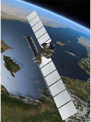
The Sentinels will perform a continuous "health check" on the planet
The date has been set for the roll-out of the European Union's multi-billion-euro Earth observation project.
Copernicus will fly a constellation of satellites known as the Sentinels to take a continuous "health check" on the planet and to acquire data that can help inform and enforce EU policies.
It has been announced that the first spacecraft in the series will go into orbit, most likely, in early April.
Sentinel 1a will use radar to map the surface of the Earth.
Its information will find myriad uses, from monitoring European coastal waters for oil spills to investigating subsidence in cities.
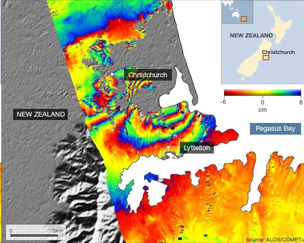
A key role also will be to provide rapid damage maps to enable emergency services and aid agencies to respond to natural disasters such as earthquakes and severe flooding events.
Sentinel 1a is undergoing final testing at prime contractor Thales Alenia Space, at its facility in Cannes, France.
Shortly, it will be transferred to Turin, Italy, where it will take an Antonov transport plane to the Guianese spaceport in South America.
There it will be fuelled and attached to its Soyuz rocket, ready for an ascent no earlier than 28 March.
"We're making every effort to meet this date, but it's tight," said European Space Agency (Esa) director general, Jean-Jacques Dordain.
"The industrial teams are working double shifts, pretty much seven days a week," he told BBC News. 1 April is his anticipated launch date.
Copernicus is one of two flagship EU space projects, the other being the Galileo satellite-navigation system.
European states have so far committed some 7.5bn euros (£6.2bn; $10.2bn) to the end of the decade to build and operate Copernicus.
As such, it represents the biggest civilian Earth-observation project ever conceived, says Josef Aschbacher, the head of Esa's Copernicus office.
"Typically in Europe, we're always looking across the Atlantic and if we see something we like, we build a smaller version of it here. But something like Copernicus doesn't exist anywhere else in the world, and that's why our American and other international partners are extremely interested in collaborating."
Satellites are at their most powerful when their data is continuous and unbroken in time. To that end, the vision for Copernicus is that becomes an open-ended mission of overlapping satellites.
A Sentinel 1b is already in production, with early discussions already taking place on the procurement of the 1c and 1d models.
Likewise, the first satellites in the Sentinel 2 and 3 series are well advanced. These will carry instruments focused on changes that occur over time in land cover and ocean behaviour, and will launch next year.
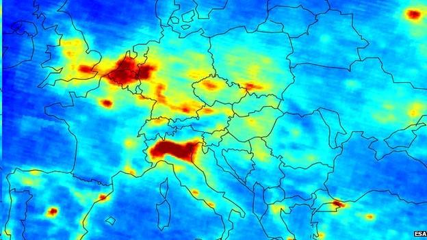
Atmospheric sensors known as Sentinel 4 and 5 will go up later this decade. Sentinel 6 will continue the work of a current satellite that measures the height and shape of ocean surfaces.

Sentinel 5 will map pollutants produced by power plants, heavy industry and road transport
The EU does not have any technical expertise of its own to develop such a programme and so has engaged Esa to design and commission Copernicus on its behalf.
The Sentinels will produce prodigious volumes of data - all of it free and open. This has required not only considerable investment in computer storage and processing capability on the ground, but a new fast-link technology for bringing the satellites' information down to Earth.
Whereas current Earth observation satellites use radio transmitters to downlink data when they pass over ground stations, the Sentinels will instead fire their data via a laser to a telecommunications satellite much higher in the sky before it is then passed to Earth.
The laser relay will eventually permit two-gigabit-per-second connections. Sentinel 1a's task will be to fully demonstrate this technology before its use becomes routine on the later spacecraft.
"Sentinel 1 will be producing 600GB per orbit which means something like 2.5 terabytes per day," said Ramon Torres, Esa's Sentinel 1 project manager. "This is raw data. In the case of [radar], when we process this we end up multiplying by a factor of five. This is why we are building a monster of a ground segment."
Although led by TAS (Italy), the construction of Sentinel 1a has involved the participation of many companies across Europe. Major subcontractors have included Ruag (Switzerland), which built the satellite's basic structure, or chassis, and Airbus (formerly Astrium), which developed the radar instrument in its German division and the associated electronics in its UK division.
The follow-on model is making steady progress, says Claudio Bruno of TAS. "The date of shipment of Sentinel 1b from Cannes will be November 2015."

Radar is used to map the ground deformation resulting from quakes, such as the damaging 2011 Christchurch event
Jonathan.Amos-INTERNET@bbc.co.uk and follow me on Twitter: @BBCAmos, external
- Published25 July 2013
- Published11 February 2013
- Published14 June 2012
- Published8 December 2011