Satellites track snail disease risk
- Published

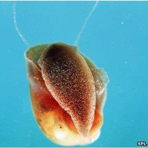
People come into contact with the schistosomiasis parasite when they enter water frequented by the snails
Scientists are tracking snails from space in a bid to combat the spread of parasitic disease in Africa.
The satellite information is being used to predict where infections are likely to occur, enabling health agencies to better target their resources.
It is one example of the growing influence of space-borne data in new healthcare applications.
The development was reported at a meeting of American Association for the Advancement of Science, external in San Jose.
It is not possible, of course, to see individual snails from orbit, but specialists will have a very good idea of where these creatures prefer to be and the conditions under which they will thrive.
And so it is with the watersnails that carry the larvae of the worms that spread schistosomiasis through human populations in Africa. The disease is not usually a killer, but it is debilitating.
In Kenya, scientists are making satellite maps of all the watercourses where these snail carriers are likely to reside, and plotting how they will move across the landscape. This information is then compared with satellite data on where people live on that landscape.
The combination of the two maps shows the highest risk locations - the places health programmes should be concentrated.
Similar work is being done with disease-spreading insects, such as mosquitoes.
Ground truth
This field of spatial epidemiology has benefitted from the avalanche of data now coming from Earth observing satellites.
Uriel Kitron from Emory University in Atlanta, Georgia, conducted the schistosomiasis work in Kenya.

The watersnail hosts a key stage in the parasitic worm's life cycle
"One of the big challenges that all public health agencies have - and that's true you know in the UK, in the US or in Kenya - is limited resources.
"If we can help them target the resources in space and time, that is a huge service we can do."
Ken Linthicum from the US Department of Agriculture has been using space data to forecast the future risk of malaria, dengue fever, chikungunya and Rift Valley virus.
He cautions that satellites, as wonderful as they are, still have to be supported by work on the ground.
“The key is understanding the ecology and transmission dynamics of the disease beforehand. It's not really appropriate to look at data and then say, 'ok, how can I use that data?'.
"You have to know what’s going on with the disease. In the case of Rift Valley fever, we discovered that it was heavy rainfall that floods habitats, producing the hatch of mosquito eggs that produce the virus. In the case of chikungunya or dengue in Africa, for example, it’s drought conditions that enhance mosquito-breeding habitats near people and then the high temperatures that boost transmission in the mosquito."
European system
But used with care, the satellite information can prove very powerful, said Prof Kitron.
"Another good example is lyme disease. Soil moisture is very important for survival of the ticks that transmit it. So, by mapping soil moisture by satellite you can create a good risk map.
"Another obvious one is vegetation because different types of vegetation are associated with different insect vectors of disease, or with birds and rodents that might be important. We can now actually map not just where there is vegetation, but the type of vegetation.”
The volume of data used in these applications will jump massively over the next few years as the European Union rolls out its Sentinel satellites, external.
This fleet of spacecraft represents the largest commitment in history to the observation of Earth from orbit, and all the information will be open and free to use.
Archie Clements from the Australian National University commented: "I do think there is going to be some key advantages of the availability of this data, partly because the spatial resolution is going to be high and also because the temporal resolution is going to be high – which means we’re going to be able to track the dynamics of diseases much more effectively over time and look at patterns of disease emergence and change."

The European Union is building a new constellation of satellites called the Sentinels
Jonathan.Amos-INTERNET@bbc.co.uk an follow me on Twitter: @BBCAmos, external
- Published2 April 2014
- Published22 January 2015
