How the jet stream changes UK weather
- Published

The jet stream was behind the UK's wettest April on record
The jet stream is a zone of fast moving winds, typically flowing around the globe at mid-latitudes around six miles above the earth's surface.
A decent jet stream moving across the Atlantic can have wind speeds in excess of 150mph.
The jet streams are powered by the huge temperature contrasts between the polar regions of the planet and the equator.
Sometimes, the jet stream will accelerate and when this happens, air is forced to move upwards through the atmosphere. This will tend to lower the atmospheric pressure at the earth's surface.
It is these areas of low pressure that bring us unsettled weather.
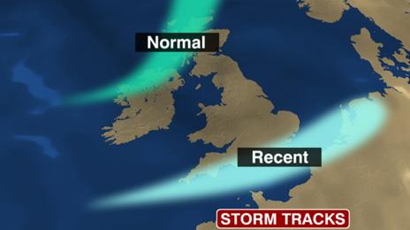
In a normal summer, the jet stream would typically pass to the northwest of Scotland, bringing rain to the northwest of Britain and drier weather to the southeast.
This year, the jet stream has often got 'stuck' - more or less across southern England - which brings the low pressure systems straight across England and Wales.
This stuck weather pattern has resulted in us having the wettest April on record.
And with a similar stuck jet stream pattern predicted for much of June, we can expect these unsettled conditions to be with us for at least the next fortnight.
How the jet stream has changed

- Published8 June 2012
- Published9 June 2012
- Published8 June 2012