Warnings over storm due to hit England and Wales
- Published
Autumn storm approaches UK
Weather forecasters are warning of stormy conditions in England and Wales on Sunday night and Monday.
A Met Office amber alert, external for high winds in southern Wales, southern England, much of the Midlands, the East, and London and the South East is in place.
There is concern about possible heavy rain, falling trees, building damage and gusts of up to 80 mph (130 kph), or possibly higher on exposed coasts.
The Met Office said the predicted storm was not one "you would see every year".
It says 20-40mm (0.80-1.6 ins) of rain might fall within a period of six to nine hours across all areas.
A yellow alert warning of heavy rain that could lead to surface water flooding and disruption is in place for all areas, apart from London and the east of England.
This is the lowest level of the three warnings issued by the Met Office and advises people to "be aware".
An amber alert, advising people to "be prepared" for potentially hazardous conditions, is one level up from this.
The Environment Agency has warned of the possibility of surface water flooding, external on Monday but currently assesses it as a "low risk".
A spokesman added: "EA teams are out working to minimise river flood risk, clearing debris from streams and unblocking culverts. We will continue to closely monitor the situation ready to issue flood warnings if needed. We are supporting local authorities who will respond to any reports of surface water flooding.
"Seafronts, quaysides and jetties should be avoided due to the risk of overtopping by waves and wind blown shingle."
Ferries cancelled
Michael Fish: "With all that information we can warn the public...which, many years ago, wouldn't have been possible"
BBC Weather presenter Stav Danaos says the storm is contained in an area of low pressure in the Atlantic which developed off the east coast of the US.
It is currently "hurtling along" on the back of a strong jet stream and is expected to deepen and strengthen through Sunday as it approaches the UK, he says.
The strongest winds are expected on the storm's southern and western flanks.
In other developments:
Forecasters said the "very intense low pressure system" would bring the potential for strong winds, especially on exposed coasts in Cornwall, Devon, Dorset, Hampshire, West Sussex, East Sussex and Kent
Two Brittany Ferries services on Sunday afternoon and evening have been cancelled between Plymouth and Roscoff because of the storm forecast. All services from Penzance to the Isle of Scilly have been cancelled on Monday, while sailings on Channel Island high speed ferry services are also affected
The Metropolitan Police is urging people to use its 101 number during the storm, external rather than 999, unless there is a "genuine" emergency
The AA said stormy conditions could cause "significant travel disruption on Monday morning... one of the busiest times on the roads"
The Met Office says the public should be prepared for the risk of falling trees as well as damage to buildings and other structures, bringing disruption to transport and power supplies.
It says the storm is expected to run across the country in a north-easterly direction but there is still some doubt about the "timing, intensity and track of the low".
Tree risk
Darron Burness, head of the AA's flood rescue team, said: "Strong wind and torrential rain is an unpredictable and hazardous combination, which can be quite overwhelming when you're driving.
"There's likely to be tree and other debris on the roads as well as potential flooding, so it's very important to keep your speed down and drive with great care."
The Met Office is predicting gusts in some areas could be similar in strength to storms in March 2008, January 2007, October 2000 and January 1990.
Wind speeds of 115 mph were recorded during the so-called Great Storm of October 1987.
Forecaster Michael Fish, who famously reassured viewers that there was not "a hurricane" on the way in 1987, predicted that the weather over the coming days would not rival the Great Storm.
He told the BBC News Channel: "Present thoughts are there are three storms it's comparable to - March 2008, January 2007 and October 2000.
"They certainly weren't as powerful as the 1987 storm."
He said computers had made it much easier for forecasters to accurately predict weather patterns and warn people to take precautions before storms hit.
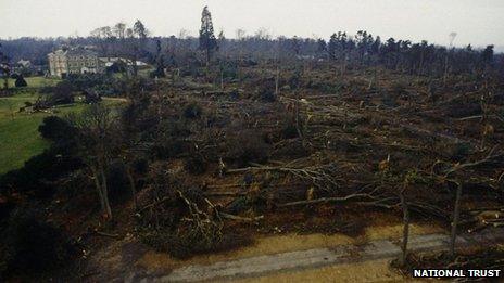
Jill Attenborough, of the Woodland Trust, said 15 million UK trees fell in 1987 and warned more were now "exposed" because of a reduction to woodland areas for the building of roads, railways and housing.

Millions of trees fell during the infamous storm in October 1987
She said part of the reason so many trees fell was that many were in "full leaf" at that time, catching "the wind like a sail", and the same risk applied to the forecast storm.
Ms Attenborough urged people to use "common sense" and stay away from woodland in high winds.
Steve Scott, from the Forestry Commission, said the organisation now designed its woodlands with more open space.
He added: "The truth is, if the wind blows sufficiently strongly, it will blow trees down and so our preparedness is about how we deal with the aftermath."
There is more information about the forecasts for Sunday and Monday on the BBC Weather, Met Office, external and Environment Agency, external websites. See BBC Travel News for up to date travel information and the Highways Agency, external and Traffic Wales, external websites for details about road conditions. BBC Local, external has information from your area.
- Published26 October 2013
- Published24 October 2013