JRR Tolkien's annotated Middle-earth map on show at Bodleian
- Published

A map of Middle-earth annotated by JRR Tolkien is on show at the Bodleian
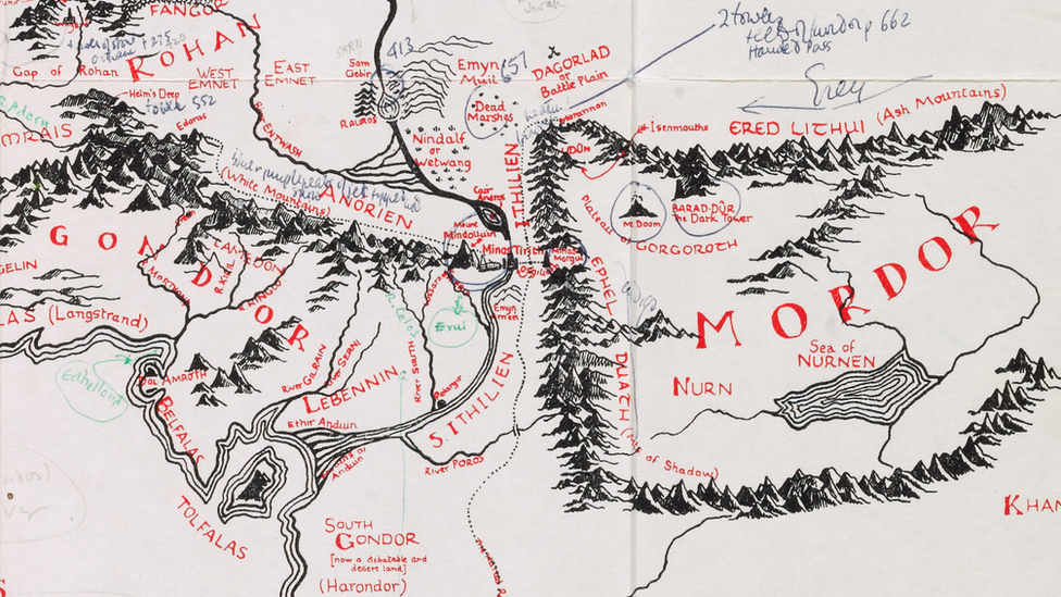
A map of the fictional Middle-earth annotated by Lord of the Rings author JRR Tolkien has gone on display.
The map, which was recently bought by Oxford's Bodleian Library, was previously owned by illustrator Pauline Baynes, who produced the first illustrative map for Tolkien's trilogy.
It was unseen for decades until a bookshop put it on sale for an asking price of £60,000 last October.
It had been due to be displayed for one day at the Bodleian's Weston Library.
But its popularity prompted the library to extend the display for an extra day on Friday.
Tolkien annotated the map in 1969 in green ink and pencil, adding place names in Elvish - one of the languages he created for the books.

The 1969 map - developed from Tolkien's annotations - depicted the Fellowship of the Ring and included illustrations of Argonath and the Teeth of Mordor
He also instructs Baynes on the placement of important towns and cities like Hobbiton, the home of the trilogy's hero Frodo Baggins.
In one annotation he writes Hobbiton should be "approximately at the latitude of Oxford", where the author lived.
Other notes include the colours the ships should be painted and where animals should appear on the map.
Until then The Lord of the Rings had never been illustrated and Tolkien was keen to ensure his world was depicted accurately.
Baynes was introduced to Tolkien when she first submitted illustrations for his Middle-earth epic in 1949 and was the only artist personally approved by him during his lifetime.
Tolkien went on to introduce her to fellow author CS Lewis, for whose Narnia books she also went on to produce illustrations.
The map, which was bought by the Bodleian Libraries in the region of the asking price, is now part of its Tolkien archive.
Speaking about the author's connection to Oxford and the university, the Bodleian Libraries' keeper of special collections, Chris Fletcher, said: "Tolkien spent almost the whole of his adult life in the city and was clearly thinking about its geographical significance as he composed elements of the map."
It was originally drawn by Tolkien's son Christopher for the 1954 edition of the book.


Tolkien in Oxford
In 1911 he went to Oxford University, aged 19, to study Greats (Classics) at Exeter College, later switching to English and graduating with a first-class degree
After serving in France during World War One, he worked on the New English Dictionary (later the Oxford English Dictionary)
From 1925 to 1945 - Rawlinson and Bosworth Professor of Anglo-Saxon
From 1945 to 1959 - Merton Professor of English Language and Literature
Retired in Oxford and worked on The Silmarillion, which was published posthumously in 1977
Buried with his wife Edith in Wolvercote Cemetery
- Published3 May 2016
- Published16 February 2016
- Published7 December 2014