Historic Australia map 'should stay' in England
- Published

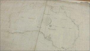
The map is thought to be the first document to use the word Australia
A Somerset historian has said a historic map of Australia that is the subject of a campaign to have it sent abroad should remain in England.
A group of Australian politicians and academics have started a campaign to get the chart, held at the Hydrographic Office in Taunton, sent to Australia.
The document is thought to be the first map to use the word Australia.
It was drawn by a British naval officer in 1804 when the island was known as Terra Australis or New Holland.
After circumnavigating Australia, Captain Matthew Flinders was captured by the French and drew the map while in prison on the island of Mauritius.
Campaigners have now launched a petition to the British government to take the map to Australia in time for the bi-centenary of Capt Flinders' death in 2014.
Australian MP Greg Hunt said in a statement: "This is the true birth certificate of our nation and deserves to be placed on public display here in Australia.
"A document so vital to our national heritage should not remain in obscurity. We want to work co-operatively with the British Government to have Flinders' original map gifted to the people of Australia."

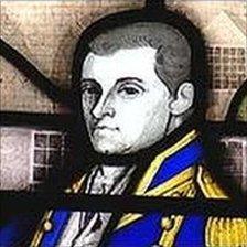
The map was drawn by British naval officer Captain Matthew Flinders
The map has been dubbed the Elgin Marbles of Australian history.
The 2,500-year-old Parthenon Marbles, also known as the Elgin Marbles, were removed from the ancient Greek Parthenon in 1811 by Lord Elgin, the British ambassador at the time.
They have been in the British Museum in London since 1817. Greece hopes one day to display the collection in the Acropolis Museum.
Somerset's former county historian disagreed with the campaigners' argument.
Dr Robert Dunning said: "The Elgin Marbles are real things pinched from Greece, in my view perhaps they ought to go back.
"But this chart was never pinched from Australia, it was actually compiled by an Englishman at the behest of Englishmen and taken back to England where it belongs."