Journey to the 'lost triangle'
- Published

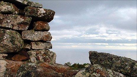
Ruins at Badbea with the Moray Firth and Beatrice oil field in the background
Lichen encrusted ruins mark the cliff top settlement of Badbea on the east Caithness coast.
It was once home to families who had been evicted from nearby straths to make way for large-scale sheep production during the Highland Clearances.
Reached by a short walk along a narrow track carpet-bombed with sheep droppings, Badbea provides outstanding views across the Moray Firth.
The story goes that Badbea parents tethered their young children to rocks to stop them wandering, or being blown by high winds, off the nearby cliffs.
Today there are efforts to harness those feared winds to generate huge amounts of electricity.
In good weather, two demonstrator turbines are just visible on the horizon at the location of the Beatrice oil field.
They are plans to install hundreds of turbines in the Moray Firth and harness wave and tidal energy off the coasts of Caithness, Sutherland and Orkney.
On a damp day in September, I travelled to Thurso to find out what local hopes - and doubts - there are, behind the push towards greater use of marine renewables.
The past is hard to escape on the road north.
On a hill above Golspie, in Sutherland, is a statue of George Granville Leveson-Gower, the first Duke of Sutherland, who had families moved from his land to make way for sheep.
There were calls for it to be demolished in the 1990s by people angry that the duke should be honoured in such a way.

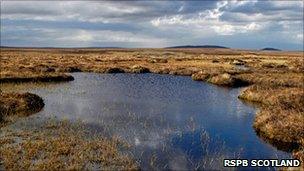
The Flow County peat bog stores millions of tonnes of carbon dioxide
A carved stone by the side of the A9 near Brora claims to mark the site where the last wolf in Sutherland was killed by a man called Polson in 1700.
On into Helmsdale and there is the Exiles statue unveiled in 2007 to mark the achievements of those who left Scotland for Canada during the Highland Clearances.
Following the A9 to Thurso where the road forks just north of Dunbeath and the landscape is dominated by the Flow Country, a vast expanse of peat bog.
It is the largest Atlantic blanket bog in the world.
According to the International Union for Conservation of Nature (IUCN), it covers 400,000 hectares with layers of peat to depths of a metre to 12m.
To conservationists, it plays an important part in combating climate change.
The IUCN estimates the Flow Country stores one billion tonnes of carbon dioxide.
Scotland's annual carbon emissions are thought to amount to 50-60 million tonnes.
Clifton Bain, director of the IUCN UK Peatland Project, is preparing for a commission of inquiry into the state of Scotland's peat bogs next month.
He said: "When these bogs are damaged by fire or drainage they will lose four tonnes of carbon dioxide a year for every hectare damaged.
"RSPB Scotland is trying to restore 10,000 hectares of bog.
"Recovery can be quick - about five years - as mosses and other plants return."
Mr Bain added: "Protecting peat bog is in the Scottish government's toolkit of measures to tackle climate change."
The inquiry will open in Edinburgh on 3 November and take evidence from scientists, conservationists and landowners.
At Causeymire, wind turbines rise from the peatland like machines from HG Wells' War of the Worlds.
In Thurso, I speak to poet and playwright George Gunn about the likely impact of marine energy developments on the local area.
Gunn is all for the use of renewables, but unconvinced by forecasts of new jobs and investment for the north.
He believes people from outside the area struggle to understand Caithness.

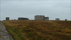
Wartime buildings at Dunnet Head - the most northerly point on Britain's mainland
Gunn said: "Caithness does not conform to most people's idea of the Highlands in that there are not mountains and it is not an island.
"Caithness is the lost triangle - it has the sea on two sides and a bog on the other. In a way it is both Highland and island."
The lighthouse at Dunnet Head - the most northerly point of Britain's mainland - is journey's end.
Fog obscures the view over the Pentland Firth.
A handful of people wrapped up in waterproofs trudge around in the mist and take pictures of the lighthouse.
Drab war-time buildings stud the hillside rising nearby.
Thousands of military personnel were stationed here tasked with looking out for surfaced U-boats and German warships.
Royal Navy submarines use the firth today.
In the past few days, subs were scheduled to pass through while participating in Exercise Joint Warrior.
Gunn said World War II had been "good" in terms of providing income for farmers supplying military sites in Caithness.
His own grandparents were kept busy supplying an RAF station with eggs and bacon.
Sixty-five years since the end of World War II with its black outs against air raids, and the north of Scotland is playing a key role in keeping the lights on.