Wales snow: Warning of ice after day of disruption
- Published
The BBC's Hywel Griffith: One family woke "to find these cars had landed with the snow"
Motorists are being warned snow may turn to ice later as temperatures plunge following a day of travel disruption.
Treacherous conditions remain on roads across Wales and gritters will be out in force across the country once again.
Snow brought chaos on Friday leaving homes without power, 1,388 schools shut and disruption to trains and buses.
While the snow should ease later, an ice warning is in place for much of Wales over the weekend.
The Met Office said there could be sub-zero temperatures overnight and into Saturday morning causing a risk of localised disruption to travel.
A rare Met Office red warning, external for snow and blizzards remained in place until 21:00 GMT Friday for part of the Brecon Beacons and Black Mountains, although it said the worst of the snow has now fallen in this area.
The warning advises people to avoid any non-essential travel.
There is also an amber warning covering most of the country, which means around 5 to 10cm (2 to 4 ins) of snow is expected.
On Friday, a band of snow moving north caused disruption around Wales.

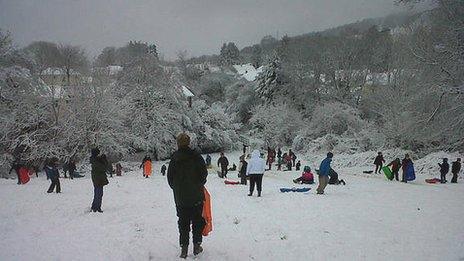
Children who were off school went sledging on Twmpath in Rhiwbina, Cardiff
Travel problems are still widespread with many main roads treacherous and some completely blocked.
The M48 Severn Crossing is closed in both directions because of the snow, while one lane is closed in both directions on the M4 Second Severn Crossing.
The Penderyn, Maerdy, Bwlch and Rhigos roads all remain closed and others that are closed include:
A4075 in Carew, Pembrokeshire, because of flooding.
A4212 at Trwsfynedd, Gwynedd, because if snow.
In Powys, the A4215 at Libanus, the A487 at Derwenlas, the A481 at Llanelwedd and the A44 at Crossgates because of ice and snow.
A542 Horseshow Pass in Llangollen, Denbighshire.
The A487 between Nebo and Bryncir in Gwynedd, which was closed because of a jack-knifed lorry, has now reopened and is passable with care.
Snow brought chaos leaving homes without power, 1,388 schools shut and disruption to trains and buses
Although the A55 in north Wales remains open, police have warned motorists to drive with "extreme care" because of "blizzard conditions".
One lane at Dwygyfylchi was impassable, according to officers.
Cardiff Airport closed its runway for a time during the morning and train services were also disrupted, particularly in the south Wales valleys.
Network Rail, external is reopening lines as the heavy snowfall stops and Arriva Trains Wales said disruption was easing.
However, First Cymru Buses, external said all services in Swansea, the Swansea Valley, Neath and Port Talbot would stop running by 19:00 GMT on Friday because of the icy road conditions.
Cardiff Bus said it would run a reduced service in the capital until 23:20 GMT, with several services suspended.
The company said it was monitoring the weather and that bus services would be reviewed again on Saturday morning.
Some 10,000 homes were at one stage left without power in parts of south, west and north Wales due to faults caused by the weather. The majority have since had power restored.
Saturday will be mostly cloudy with further snow in places, most of it in the east and north-east
In north Wales, pockets of customers mainly in Gwynedd and on the Llyn Peninsula were left without power.
Some health boards cancelled non-essential appointments to focus on acute services, while volunteers from the British Red Cross are driving 4x4 vehicles to help district nurses reach their patients in north and west Wales.
The 4x4 support is also available to the GP out-of-hours service run by Betsi Cadwaladr University Health Board over the weekend.
In total 1,388 schools around the country were shut, with pupils in counties such as Rhondda Cynon Taf, Torfaen, Swansea and Neath Port Talbot enjoying a day off.
Some secondary schools remained open only for pupils sitting exams while many universities and colleges were also closed because of the weather.

There may be a little more snow on Sunday, according to the forecast
BBC Wales meteorologist Derek Brockway said snow in the north and east would gradually ease off on Friday night.
"Elsewhere it will be drier and breezy with a widespread frost, and ice will be a hazard with lying snow and slush freezing as temperatures drop," he said.
"Saturday will be mostly cloudy with further snow in places, most of it in the east and north-east, generally light but giving further accumulations in places, especially on the hills and mountains.
"On Sunday there may be a little more snow in the east and north-east. Otherwise it should be dry with a risk of freezing fog and ice.
"There will be some sunshine in the west but still cold with an easterly breeze."
- Published18 January 2013
- Published18 January 2013
- Published18 January 2013
- Published18 January 2013
- Published18 January 2013