Storm Eunice: Wales set to be hit by 100mph winds
- Published
Wales was battered by heavy winds following the arrival of Storm Dudley
Winds of up to 100mph could batter parts of Wales on Friday, with people warned to stay indoors.
Storm Eunice is predicted to cause power cuts, damage to homes, coastal flooding and travel chaos.
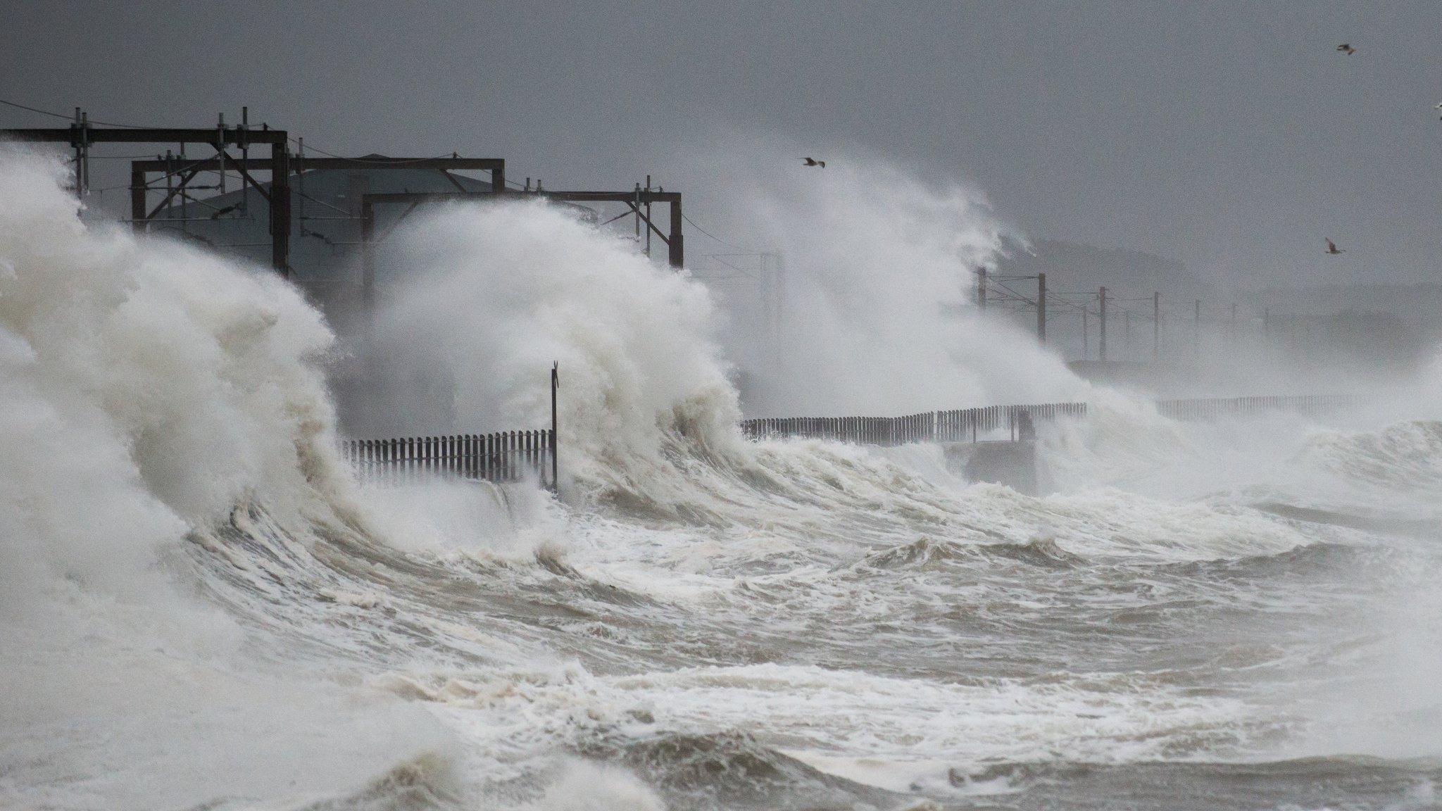
The Met Office has issued an amber warning for Friday because of strong winds, with the possibility of a "very rare" red warning for some areas, external.
It comes after Storm Dudley caused power cuts, felled trees and blew a trampoline on to rail lines at Cardiff.
Train firm GWR said: "The 14:22 Swansea to Paddington service struck an object on the line near Cardiff just after 16:00."
Looking ahead to Friday, BBC weather presenter Sabrina Lee warned there could be winds of up to 100mph (160km/h) in coastal areas.
This could cause flying debris, large waves and falling trees, with Ms Lee saying Friday is "not a day to venture out".
She added: "We're still keeping an eye on the track of the storm. There is the potential for some areas to be included in a red wind warning. These sorts of warnings are rare."

An amber warning has already been issued for Friday
Natural Resources Wales warned there was potential for "many" flood warnings across all coastal areas.
Duty tactical manager Ross Akers said: "Forecasted high winds could cause a storm surge and large waves which could lead to the overtopping of flood defences along the coast.
"We are monitoring the situation very closely, but we are concerned that if the forecast does materialise, then we are likely to see significant flooding impacts in many places along our coastal areas.
"Keep a safe distance from coastal paths and promenades as large waves can sweep you off your feet or you can be hit by debris."
A yellow "be prepared" warning is already in place from 13:00 GMT Wednesday until 06:00 Thursday, covering parts of north-east, north-west and mid Wales.
Storm Eunice is expected to affect all of Wales from 03:00 until 21:00 on Friday.
Ms Lee added: "For inland areas there is the potential for gusts 60-70mph, possibly up to 90-100mph for some coastal locations."
Allow X content?
This article contains content provided by X. We ask for your permission before anything is loaded, as they may be using cookies and other technologies. You may want to read X’s cookie policy, external and privacy policy, external before accepting. To view this content choose ‘accept and continue’.

On Wednesday the Met Office said Storm Dudley would bring 70mph winds (110km/h) to Ceredigion, Conwy, Denbighshire, Flintshire, Gwynedd, Anglesey, Powys and Wrexham.
It warned of damage to buildings, tree falls and power cuts, external.
By 17:00, Snowdonia's Capel Curig had experienced gusts of up to 81mph (130km/h).
Met Office forecaster Greg Dewhurst said: "Exposed areas in Scotland, Northern Ireland, parts of Wales and northern England have seen wind speeds largely between 60 and 70mph, but the worst affected areas have reached and even surpassed 80mph this afternoon."
Natural Resources Wales also has flood alerts in place, external in south, mid and north Wales.
The M48 Severn Bridge has been closed in both directions, between junction two on the A466 Wye Valley Link Road at Chepstow and junction one on the A403 at Aust, due to the strong winds.
Traffic is believed to be coping well since the closure at 12:00. A diversion is in place via the M4 Prince of Wales Bridge.
Transport for Wales said a trampoline was blocking the line at Cardiff East, affecting services to and from Cardiff Central.
Gwent Police warned a tree was "completely blocking" the A4043 at Blaenavon shortly after 16:00.
At Tesco on Cardiff's Western Avenue, part of the roof was damaged and some of the car park fenced off.
Almost 600 homes were without power in Ystradgynlais on Wednesday afternoon, though this had dropped to 100 by 16:15.
Western Power also reported a number of other power cuts.
Allow X content?
This article contains content provided by X. We ask for your permission before anything is loaded, as they may be using cookies and other technologies. You may want to read X’s cookie policy, external and privacy policy, external before accepting. To view this content choose ‘accept and continue’.
The under-18s clash between Cardiff Rugby and Newport's Dragons has been moved from Cardiff Arms Park to Ystrad Mynach because of the weather.
Gale force winds caused minor damage to the stadium, which could not be safely inspected in current conditions, the club said.

The river Usk in full flow at Brecon Promenade, Powys, on Tuesday afternoon
On Tuesday, there was a small landslip on the A493 between Pennal and Dyfi Bridge, near Machynlleth, but the road remained open.
The A55 Britannia Bridge has a 30mph speed limit in north Wales because of strong winds.


THE TUCKERS ARE BACK: They might not always be on the right side of the law, but who's telling?
LOVE LETTER TO WRESTLING: The best there is, the best there was, the best there ever will be

Related topics
- Published15 February 2022
- Published15 February 2022