Aurigny rolls out system for Alderney and Southampton
- Published

Mr Rice said a normal instrument landing system was too expensive for the size of Alderney Airport
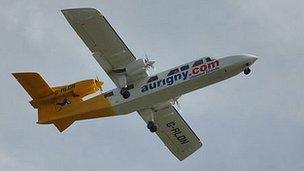
Aurigny's fleet of trislanders will use a satellite landing system to make it easier to land at Alderney Airport.
The airline has trialled the system for a year and been given permission to use it by the Civil Aviation Authority.
David Rice, flight operations director, said it allowed planes to land in worse weather than currently possible.
He said the new system improved the long-term viability of the trislander aircraft.
The new system is expected to be installed on all the company's trislanders early in 2012.
Mr Rice said the system meant "low visibility approaches to Alderney can be made that would perhaps not otherwise have been possible.
"Unlike Guernsey, Jersey and many other European airports, Alderney is too small to justify the cost of an instrument landing system."
It utilises information from European Geostationary Navigation Overlay Service (Egnos) which uses GPS to make low-visibility landings easier.
Mr Rice said: "It will be of a huge benefit to our Alderney operations and we are delighted to have led the way in testing it.
"Southampton Airport is also planning to introduce approach procedure using Egnos."
Colin Le Ray, Guernsey Airport's director, said: "This new process will create additional flight training business for Alderney and for this reason it puts Alderney Airport well and truly on the map."
- Published17 September 2011
- Published15 September 2011
- Published22 August 2011
- Published20 September 2010
- Published3 August 2010