New 3D maps reveal 2.3 million square miles of Mars
- Published

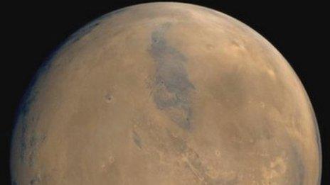
German scientists have made a giant 3D map of Mars by merging thousands of pictures together.
Normally the pictures we see from Mars are narrow snapshots of small areas.
But experts at the German Aerospace Center have made a mosaic of these images to create a single, highly detailed map of the rocky surface.

Colour-coded images show the differences in height on the terrain
Now, the mosaic shows more than two million square kilometres of the Red Planet in 3D reconstructions.

97% of the surface has now been mapped
It's hoped it could help astronomers to explain how water and lava once flowed across the planet.

Deep craters appear green while higher ground is red and orange
- Published3 October 2014
- Published10 December 2014

- Published14 July 2011